Circular route from Arrelles to Avirey-Lingey

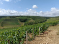
Starting from Avirey-Lingey, this walk around the Sarce leads to the village of Arrelles through a landscape of woods, meadows and vineyards. 

Details

n°71344764
Creation:
Last update:
Last review:
  • Walking
    Activity: Walking
  • ↔
    Distance: 8.20 mi
  • ◔
    Average duration: 4h 15 
  • ▲
    Difficulty: Moderate

  • ⚐
    Back to start: Yes
  • ↗
    Ascent: + 538 ft
  • ↘
    Descent: - 525 ft

  • ▲
    Highest point: 951 ft
  • ▼
    Lowest point: 597 ft
  • ⚐ Country: France
  • ⚐ City: Avirey-Lingey (10340)
  • ⚑
    Start/End: N 48.026044° / E 4.300671°
  • ❏
    IGN map(s): Ref. 2818SB, 2819SB, 2918SB, 2919SB
  • Hour-by-hour weather

Description of the walk

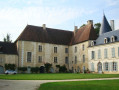
Park in the car park near the church or in the car park by the village hall, which is right next to it.

(S/E) Leave the car park and head straight ahead onto Rue du Torchepot. At the bend, turn right onto a rather picturesque path running alongside the Sarce (stream) as far as Lingey. 

(1) Turn right, cross the bridge, then turn left onto the GR®654: marked with red and white signs. Continue straight on until you reach the Val du Mast junction.

(2) Leave the GR®654 and continue straight ahead to reach the pumping station.

(3) Pass the bridge on your left and carry on straight ahead at the foot of the Côtes d’Arrelles. You’ll come out onto Rue des Petites Côtes; turn left to join the D36.

(4) Carry on to the left, cross the bridge over the Sarce, then turn immediately left along the river onto Rue du Lavoir. Leave the street at the bend to follow a path which then turns to the right before coming out onto the D32.

(5) Cross carefully to join the path opposite, take a left-hand bend, then a right-hand bend, and arrive at a three-way junction. 

(6) Keep to the left and begin a climb through more undulating countryside.

(7) Keep left again at the three-way junction and continue along the path which follows a double power line before passing briefly underneath it. You’ll reach an area planted with vines. 

(8) Turn left to cross a few plots of land and emerge onto the D142 at the entrance to Lingey; cross the road with care. 

(9) Take a sharp right-hand bend to join a path leading away from Lingey, pass under three successive power lines and head up the Combe Nicolas Camus.

(10) Turn left to follow the Combe Godé and reach the edge of the Bois du Hayet. 

(11) Turn left to walk alongside it, then carry on straight ahead along a path that leads to another wooded area. Turn right at the three-way junction and head for a stunning viewpoint over Avirey.

(12) Follow the ridge path to the end, passing once again under the three successive power lines.

(13) Head down to the right to come out onto Rue du Val d’Avirey and turn left towards the village centre. Cross the county road at the pedestrian crossing and head for the car park (S/E). 

Waypoints

  1. S/E : mi 0 - alt. 640 ft - Church car park. Walk alongside the - Sarce (rivière) - Affluent de la Seine
  2. 1 : mi 0.53 - alt. 630 ft - Lingey
  3. 2 : mi 1.59 - alt. 620 ft - At the junction, go straight on
  4. 3 : mi 1.87 - alt. 607 ft - Pumping station
  5. 4 : mi 2.32 - alt. 604 ft - D36
  6. 5 : mi 2.59 - alt. 636 ft - D32
  7. 6 : mi 2.83 - alt. 617 ft - Three-way junction, turn left
  8. 7 : mi 3.07 - alt. 702 ft - Three-way junction, turn left
  9. 8 : mi 3.9 - alt. 810 ft - Vineyards
  10. 9 : mi 4.32 - alt. 659 ft - Lingey, path on the right
  11. 10 : mi 5.56 - alt. 732 ft - Combe Godé on the left
  12. 11 : mi 5.96 - alt. 863 ft - Bois du Hayet
  13. 12 : mi 7.04 - alt. 892 ft - Viewpoint over Avirey
  14. 13 : mi 7.82 - alt. 791 ft - End of the ridge path
  15. S/E : mi 8.2 - alt. 640 ft - Church car park

Notes

At Arrelles (4), you’ll come across the River Sarce again, with a wash house and a pond with a picnic area.

Always be cautious and plan ahead when you're outdoors. Visorando and the author of this route cannot be held responsible for any accidents occurring on this route.

The GR® and PR® markings are the intellectual property of the Fédération Française de Randonnée Pédestre.

Reviews and comments

3.7 / 5
Based on 2 reviews

Reliability of the description
4 / 5
Ease of following the route
3.5 / 5
Route interest
3.5 / 5
User 21105526

Overall rating : 3.7 / 5

Date of your route : Jun 07, 2026
Reliability of the description : ★★★★☆ Good
Ease of following the route : ★★★☆☆ Average
Route interest : ★★★★☆ Good
Very busy route : No

A walk that’s not physically demanding, even for beginners. Stunning scenery in the middle of nowhere
However, you need to follow the map rather than the signposts, which aren’t always consistent
In conclusion: well worth doing
You could even plan to stop off at a champagne producer if you fancy it

Machine-translated

MARTDomi
MARTDomi

Overall rating : 3.7 / 5

Date of your route : Aug 22, 2025
Reliability of the description : ★★★★☆ Good
Ease of following the route : ★★★★☆ Good
Route interest : ★★★☆☆ Average
Very busy route : No

Country loop. Fields, woods, valleys, vineyards
A few paths we wouldn't have taken on our own. Beautiful views. A few long stretches too...

Machine-translated

Other walks in the area

For more walks, use our search engine .

The GPS track and description are the property of this route's author. Please do not copy them without permission.