Orus Viewpoint via Donseille

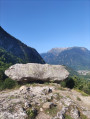
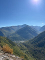
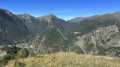
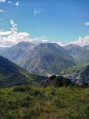
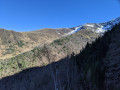
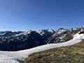
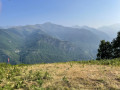
A fairly easy walk from Orus, a charming village with cobbled streets and picture-postcard scenery. The path winds through the undergrowth and ferns, past numerous low walls and abandoned shelters, bearing witness to the agricultural and pastoral activity of days gone by. The route ends at a paragliding launch site. Superb views across all the mountain ranges to the south of the Vicdessos Valley, with the Pique d’Endron in the centre and Montcalm to the right. Not to be missed!

Details

n°61062752
Creation:
Last update:
Last review:
  • Walking
    Activity: Walking
  • ↔
    Distance: 1.97 mi
  • ◔
    Average duration: 2h 05 
  • ▲
    Difficulty: Moderate

  • ⚐
    Back to start: Yes
  • ↗
    Ascent: + 1,375 ft
  • ↘
    Descent: - 1,375 ft

  • ▲
    Highest point: 4,639 ft
  • ▼
    Lowest point: 3,264 ft

Photos

Description of the walk

The starting point is the square in Orus. Please note: it is advisable to park next to the church or further down the hill before entering the village.

(S/E) Take one of the two narrow streets, Rue de la Mairie or Rue de l’Ouradou, which flank the old school and both lead to a small square with a fountain, the Place du Triet. Take the path on the right.

(1) You’ll cross a track suitable for vehicles; continue straight ahead along the signposted path (Yellow Disc). The path climbs gently or moderately through the woodland, alongside low stone walls or amongst the ferns.

(2) Take care at this point: turn left as you go uphill. The signposting is unclear here.

(3) As you emerge from the woods, the path ends. Continue for about 100 m and turn left into the forest, heading uphill at right angles to the slope. You’ll reach a meadow and a signpost indicating the paragliding area below: this is where you’ll find the beautiful panoramic view.

(4) Turn back and follow the ascent route in the opposite direction to return to Orus (S/E).

Waypoints

  1. S/E : mi 0 - alt. 3,264 ft - Orus – the Square
  2. 1 : mi 0.13 - alt. 3,425 ft - Vehicle-accessible track
  3. 2 : mi 0.66 - alt. 4,193 ft - Unmarked junction
  4. 3 : mi 0.95 - alt. 4,587 ft - End of the trail
  5. 4 : mi 0.99 - alt. 4,639 ft - Viewpoint
  6. S/E : mi 1.97 - alt. 3,264 ft - Orus

Notes

The path is marked with Yellow Discs, but these are only visible on the ascent. That’s to be expected, as paragliders only do the ascent!
On the way down, as there are no markings, make sure you spot the Yellow Discs coming from the opposite direction.
You’ll cross a few fields of ferns, which are sometimes very tall and haven’t been trimmed for walkers. But there are no particular difficulties.

Reviews and comments

4 / 5
Based on 2 reviews

Reliability of the description
4 / 5
Ease of following the route
3.5 / 5
Route interest
4.5 / 5
laptiteblan
laptiteblan

Overall rating : 3 / 5

Date of your route : Jul 30, 2026
Reliability of the description : ★★★☆☆ Average
Ease of following the route : ★★☆☆☆ Disappointing
Route interest : ★★★★☆ Good
Very busy route : No

Good news – we didn’t come across a single soul… The path seemed rather quiet; perhaps that’s why we got lost in the woods! (That said, we’re not exactly seasoned hikers.) We made our way through the ferns and caught a glimpse of the view over the valley (stunning), but we weren’t anywhere near the right spot (which we could see further on and looked like a paragliding launch site). My advice: in the woods, keep going uphill until you see the ‘paragliding’ symbols (a Yellow Disc shaped like a wing and a person); I admit it’s all a bit vague.

Machine-translated

Pat mamou
Pat mamou

Overall rating : 5 / 5

Date of your route : Aug 25, 2025
Reliability of the description : ★★★★★ Very good
Ease of following the route : ★★★★★ Very good
Route interest : ★★★★★ Very good
Very busy route : No

An easy hike to follow, with a bit of off-trail walking on the last part (thanks to the cows who made a path through the ferns). It climbs from start to finish, with no respite. But the reward is worth it: the view is magnificent.
Can be done from Vicdessos via the path leading to Orus.

Machine-translated

Other walks in the area

For more walks, use our search engine .

The GPS track and description are the property of this route's author. Please do not copy them without permission.