Baraque de Chaalis via the memorial stone

A pleasant little walk with the option of a picnic at the wooden tables provided at the Baraque de Chaalis signpost.
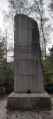
No particular difficulties; the walk passes the memorial to the plane crash of March 1974.

Details

n°58549451
Creation:
Last update:
Last review:
  • Walking
    Activity: Walking
  • ↔
    Distance: 4.42 mi
  • ◔
    Average duration: 2h 10 
  • ▲
    Difficulty: Easy

  • ⚐
    Back to start: Yes
  • ↗
    Ascent: + 174 ft
  • ↘
    Descent: - 177 ft

  • ▲
    Highest point: 361 ft
  • ▼
    Lowest point: 253 ft

Description of the walk

Access via the D126; turn right onto Route Longue and follow it to the end, to the car park at the signpost for the Baraque de Chaalis.

(S/E) The route starts opposite the car park. Take the left-hand path at the three-way Fork in the road towards the Carrefour du Bosquet, following the signs for the memorial. You’ll arrive at the Poteau du Bosquet de Dammartin.

(1) Carry on straight ahead, then take the next left towards the memorial.

(2) Retrace your steps, then take the first left and then left again towards the Carrefour de la Butte. You’ll arrive at the Route Tournante de la Longue Haie.

(3) Follow it to the right and carry on until you reach the Sainte-Marguerite signpost.

(4) Go straight on, then turn left (south-west) to reach the junction of Route Sainte-Marguerite and Chemin des Néfliers.

(5) Continue along Chemin des Néfliers, taking the second left, heading due south, until you reach Chemin des Frênes, which you should follow to the right for a short distance.

(6) Turn left onto Route des Grès Sainte-Marguerite. Turn left (south-east) and carry on straight ahead (north-east) until you reach Carrefour du Tremble.

(7) Keep heading north-east towards the Carrefour du Bosquet Rond.

(8) Take the second turning on the right (south-east) and follow theGR®1along Route du Bosquet Rond to Carrefour du Grisard.

(9) Take the second left (north-east) towards the Carrefour de Sainte-Lucie.

(10) Take the second left, Route Paré, to the Carrefour Paré at the second left-hand turn onto Route du Carbonat. Follow this road (west) to reach the Carrefour du Bosquet de Dammartin, which you passed at the start of the walk.

(1) Take the second right (north-north-west) towards the Carrefour du Bosquet, then turn left at the next junction until you reach the Carrefour des Bocteux.

(11) Turn right (north-east) onto Route Fautrat until you reach the Baraque de Chaalis car park (S/E).

Waypoints

  1. S/E : mi 0 - alt. 358 ft - Car park at the - Baraque de Chaalis
  2. 1 : mi 0.38 - alt. 344 ft - Bosquet de Dammartin
  3. 2 : mi 0.49 - alt. 335 ft - Turkish Airlines DC-10 Memorial, 3 March 1974
  4. 3 : mi 0.64 - alt. 302 ft - Route Tournante de la Longue Haie
  5. 4 : mi 1.1 - alt. 348 ft - Poteau Sainte-Marguerite
  6. 5 : mi 1.21 - alt. 351 ft - Junction of Sainte-Marguerite and Les Néfliers
  7. 6 : mi 1.53 - alt. 285 ft - Junction
  8. 7 : mi 2.02 - alt. 322 ft - Carrefour du Tremble
  9. 8 : mi 2.24 - alt. 295 ft - Carrefour du Bosquet Rond
  10. 9 : mi 2.66 - alt. 253 ft - Carrefour du Grisard
  11. 10 : mi 3.08 - alt. 318 ft - Carrefour Sainte-Lucie
  12. 11 : mi 4.04 - alt. 354 ft - Bosquet des Bocteux
  13. S/E : mi 4.42 - alt. 358 ft - Car park at the - Baraque de Chaalis

Notes

Route mapped by Monique and digitally formatted by Yves.
The .gpx track may be useful.

Always be cautious and plan ahead when you're outdoors. Visorando and the author of this route cannot be held responsible for any accidents occurring on this route.

The GR® and PR® markings are the intellectual property of the Fédération Française de Randonnée Pédestre.

Reviews and comments

4 / 5
Based on 2 reviews

Reliability of the description
4 / 5
Ease of following the route
3.5 / 5
Route interest
4.5 / 5
Hellooo
Hellooo

Overall rating : 4 / 5

Date of your route : May 13, 2025
Reliability of the description : ★★★★☆ Good
Ease of following the route : ★★★★☆ Good
Route interest : ★★★★☆ Good
Very busy route : No

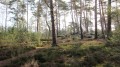
A route enjoyed in fine, warm weather. Lovely woodland, varied scenery, and sandy ground in places. A real pleasure.

Machine-translated

R.M-
R.M-

Having led this walk on 29 August 2024 – which we created and have classified as a ‘stroll’ within our association – it’s clear that a GPS is very useful for finding your way, given the number of paths we encountered. Similarly, the numerous changes in elevation we encountered lead me to rate it as 2 out of 3 ‘shoes’ (1 being easy and 3 being difficult). On the plus side, there are picnic tables in the car park of the Baraque de Chaâlis hunting lodge. Please note: during this walk, you’ll come across a pen with sheep guarded by a Patou (a Pyrenean mountain dog). Do not approach it; walk in single file and in silence, ignoring the dog, which will then simply keep an eye on you.
Enjoy your walk

Machine-translated

Aurel4325
Aurel4325

Overall rating : 4 / 5

Date of your route : Aug 24, 2024
Reliability of the description : ★★★★☆ Good
Ease of following the route : ★★★☆☆ Average
Route interest : ★★★★★ Very good
Very busy route : No

Between markers 4 and 7, it’s difficult to find your way. There are lots of paths and the route isn’t always clear enough. Best done with a GPS.

Machine-translated

Other walks in the area

For more walks, use our search engine .

The GPS track and description are the property of this route's author. Please do not copy them without permission.