Walk between Hèze, Roux-Miroir and Longueville

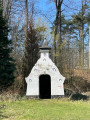
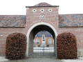
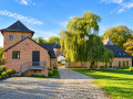
Hèze, Piétrebais, Roux-Miroir, Longueville … the first part is almost exclusively rural, passing by the Ferme du Grand Hacquedeau, which has been magnificently renovated and set off to its best advantage in an idyllic setting. After Longueville, the route becomes more wooded, crosses the Bois de Bonlez, passes the Ferme du Fort des Voiles before continuing through the Bois de Glabais and heading back up into the countryside overlooking Hèze on the southern side.

Details

n°110691443
Creation:
Last update:
Last review:
–
  • Walking
    Activity: Walking
  • ↔
    Distance: 10.52 mi
  • ◔
    Average duration: 5h 15 
  • ▲
    Difficulty: Moderate

  • ⚐
    Back to start: Yes
  • ↗
    Ascent: + 440 ft
  • ↘
    Descent: - 456 ft

  • ▲
    Highest point: 466 ft
  • ▼
    Lowest point: 249 ft

Photos

Description of the walk

(3) First possible shortcut: turn right and then right again at the next junction (cross) … leading to (7). This shortcut means you won’t get to see the magnificent, renovated Hacquedeau farm.

(5) Second possible shortcut: turn right and carry on straight ahead until you reach (7).

(8) Don’t expect to take a shortcut here by turning right towards the Ferme du Fort des Voiles: the first section of this potential shortcut runs right through the bed of the Glabais stream and is, moreover, littered with trees and branches that have fallen during successive storms. The local council has closed it off!

Waypoints

  1. S/E : mi 0 - alt. 351 ft - Vîs Tchapias Esplanade
  2. 1 : mi 0.11 - alt. 387 ft - Water Tower
  3. 2 : mi 1.99 - alt. 295 ft - Piétrebais
  4. 3 : mi 2.51 - alt. 377 ft - Acquedeau: start of the first shortcut
  5. 4 : mi 2.97 - alt. 354 ft - Hacquedeau Farm
  6. 5 : mi 3.3 - alt. 371 ft - Rue Basse: start of the second shortcut
  7. 6 : mi 4.67 - alt. 413 ft - Roux-Miroir
  8. 7 : mi 6.62 - alt. 453 ft - Longueville
  9. 8 : mi 7.19 - alt. 397 ft - Glabais stream
  10. 9 : mi 7.95 - alt. 440 ft - Grange du Sart Trail
  11. 10 : mi 8.85 - alt. 390 ft - L’Aftia
  12. 11 : mi 9.28 - alt. 276 ft - The Fort des Voiles
  13. 12 : mi 9.87 - alt. 367 ft - Chemin de la Gorge aux Loups
  14. 13 : mi 10.29 - alt. 262 ft - Ry de Hèze
  15. S/E : mi 10.52 - alt. 351 ft - Vîs Tchapias Esplanade

Notes

Benches and picnic tables at the starting point

Worth a visit

Clockmaking Museum in Longueville

Other walks in the area

For more walks, use our search engine .

The GPS track and description are the property of this route's author. Please do not copy them without permission.