Circular route around Melin and Gobertange

A walk around Melin and Gobertange offering the chance to discover some beautiful stone buildings in Gobertange. This route was explored during a 5 km ADEPS walk in Melin on 13 August 2023.

Details

n°39175209
Creation:
Last update:
Last review:
  • Walking
    Activity: Walking
  • ↔
    Distance: 3.43 mi
  • ◔
    Average duration: 1h 45 
  • ▲
    Difficulty: Easy

  • ⚐
    Back to start: Yes
  • ↗
    Ascent: + 167 ft
  • ↘
    Descent: - 154 ft

  • ▲
    Highest point: 371 ft
  • ▼
    Lowest point: 272 ft

Description of the walk

The route starts and finishes at the football ground on Rue des Beaux Prés in Melin. Ample parking available.

(S/E) At the football ground, turn left towards Melin Church and continue to the junction with Rue de la Hesserée.

(1) Turn right onto this road and carry on until you reach the Ferme de la Hesserée on your right.

(2) Opposite the farm, turn left onto a path that goes uphill and continue along it past the Ferme du Pic au vent Teerlinck until you reach a crossroads 150 metres further on.

(3) Turn left, then immediately left again onto the dirt track. Continue along this track until you reach the junction with Rue du Rivage.

(4) Turn right onto Rue du Rivage and follow it to the end, where it meets Rue de Hussompont and Rue de Gobertange.

(5) Turn left and, 100 metres further on, turn left again onto Rue de la Cloche. Continue straight on until the road bends to the right. Then turn left onto the gravel Rue de la Croix Sainte-Barbe for approximately 800 metres until you reach a road on the right.

(6) Turn right onto Rue Fond Del’Me for 150 m, then turn left and continue for 300 m until you reach a T-junction.

(7) Carry on to the left and continue along Fond Del’Mé. Cross Rue de la Maison du Bois and take the path opposite you for 700–800 metres until it joins Rue des Beaux Prés

(8) Carry on left along this road until you reach the football pitch (S/E).

Waypoints

  1. S/E : mi 0 - alt. 348 ft - Melin football pitch
  2. 1 : mi 0.13 - alt. 338 ft - Rue de la Hesserée
  3. 2 : mi 0.3 - alt. 308 ft - Ferme de la Hesserée
  4. 3 : mi 0.72 - alt. 367 ft - Ferme du Pic au vent Teerlinck
  5. 4 : mi 1.18 - alt. 295 ft - Rue du Rivage
  6. 5 : mi 1.67 - alt. 272 ft - End of Rue du Rivage
  7. 6 : mi 2.37 - alt. 292 ft - End of Rue de la Croix Sainte-Barbe
  8. 7 : mi 2.63 - alt. 328 ft - Fond Del’Mé
  9. 8 : mi 3.07 - alt. 322 ft - Rue des Beaux Prés
  10. S/E : mi 3.43 - alt. 348 ft - Melin football pitch

Notes

No specific equipment required. Please dress appropriately for the weather.

Worth a visit

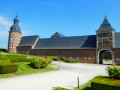
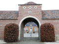
This walk offers the chance to discover some beautiful buildings, houses or farmhouses built from Gobertange stone, a pale grey limestone sourced from the village of the same name. Notably right at the start, between (S/E) and (1) in the centre of Melin, as well as on Rue du Rivage in the second part of the section between (4) and (5), featuring in particular two beautiful stone houses from the early 20th century at numbers 80 and 82, on the left-hand side of the road.

Reviews and comments

5 / 5
Based on 1 review

Reliability of the description
5 / 5
Ease of following the route
5 / 5
Route interest
5 / 5
Catherine Elleboudt
Catherine Elleboudt

A really lovely route through the beautiful village of Mélin!
Between tarmac and fields, varied and pretty!
Do you also have the route for the 10 km ADEPS walk?

Machine-translated

Catherine Elleboudt
Catherine Elleboudt

Overall rating : 5 / 5

Date of your route : Feb 25, 2026
Reliability of the description : ★★★★★ Very good
Ease of following the route : ★★★★★ Very good
Route interest : ★★★★★ Very good
Very busy route : Yes

A really lovely route through the beautiful village of Mélin!
Between tarmac and fields, varied and pretty!

Machine-translated

Other walks in the area

For more walks, use our search engine .

The GPS track and description are the property of this route's author. Please do not copy them without permission.