Country:

 City:
City:


Park in the car park opposite the Espace Henri Fabre.
(S/E) Take the street that leads down to the left for about 100 metres.
(1) Turn left onto a path leading down towards the village of Saint-Léons (GR®® de Pays, marked in red and yellow). Make a detour to the castle and then to Jean-Henri Fabre’s birthplace, then turn left onto Rue du Jardin du Prieur.
(2) At the wash house, turn right then immediately left to head down to the lower part of the village, following Rue du Fort Bas. Turn right at the fountain to reach La Muse.
(3) Continue along the stream, then cross it via a small bridge opposite the Atelier du Moulinau. Turn right onto the botanical trail. Before the end of the trail, take the small bridge on the right and head up to the small road leading to the Bois du Four.
(4) Follow it to the left as far as the Roubayrolles bridge.
(5) Leave theGRP®® on your left and follow the road for 100 m, then turn off onto the path on the right which leads to Astres (cross dated 1814). When you reach the houses, continue to the right along the small road to L’Hermet and turn right between the houses (cross dated 1888).
(6) Turn left onto a sunken track, rejoining theGRP®®, and reach the D911. Cross it carefully and follow the path to the right, between woodland and pasture, to the Bois du Four. Walk alongside the hotel’s pond, pass in front of it, and follow the D28 to the left towards Vezins for about 200 m.
(7) Take the hairpin bend to the right up the track leading to the small road to Bramariques (cross from 1867 and a 17th-century wooden cross). Turn left and follow the dirt track straight ahead.
(8) Turn right onto the track. At the small road you reach after a hairpin bend, continue straight on towards the Ferme des Arènes (cross dating from 1833). Leave theGR®® de Pays on your left and carry on to the farm buildings, following theGR®® de Pays variant
(9) Carry on straight ahead along a Causse path to La Glène.
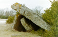
(10) Look out for the Dolmen de Lo Tombel del Gigant, set back to the left, and join the road.
Please note a change to the route: from the point with an altitude of 853, do not cross the D911 but walk alongside it on the left along a disused track, then follow a path running alongside a meadow until you reach the point with an altitude of 839 and the small service road leading to Altecassagne. Then turn right and cross the D911 here; head straight ahead, veering slightly to the right, and rejoin a road running alongside the Ovi Test sheepfolds. 300 m further on, rejoin theGR®® de Pays variant.
(11) Turn left to follow it along an old track leading to Bourrival Farm (cross dating from 1822).
(12) First turn left then right and follow the track straight ahead. At the wayside cross, follow the road to the right for about twenty metres, then leave it to turn left onto a wide dirt track and head down to the road after two bends.
(13) Turn left and walk alongside the road leading to Micropolis. Walk past the Espace Henri Fabre and head for the car park (S/E).

 Tourist office
 Easy
Easy 
 Visorando Member

 AONB
AONB