Anneville-sur-Scie_Visit to the ruined castle by La Chaussée_Ibp45F

Visit the ruined castle via La Chaussée, starting from Anneville-sur-Scie Ibp45F

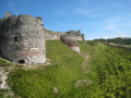
Walk taking us through La Chaussée and the Bois Hullin to descend to Longueville-sur-Scie and visit the ruins of the feudal castle of Gauthier Giffard.

Details

164461
Creation:
Last update:
Last review:
  • Walking
    Activity: Walking
  • ↔
    Distance: 8.66 mi
  • ◔
    Average duration: 4h 40 
  • ▲
    Difficulty: Moderate

  • ⚐
    Back to start: Yes
  • ↗
    Ascent: + 758 ft
  • ↘
    Descent: - 758 ft

  • ▲
    Highest point: 436 ft
  • ▼
    Lowest point: 135 ft

Photos

Description of the walk

Car park at the stadium next to the Foyer Rural Coopératif de l’Espérance at the entrance to Anneville-sur-Scie, on Route de la Mer or Route du Cidre, at the Crosville-sur-Scie turn-off.

(S/E) Take the D3 towards Crosville-sur-Scie for 100 metres and turn into the first street on the left. Cross the railway line via the bridge, then turn right.

(1) Turn left uphill onto the Route de la Chaussée and continue straight on until you reach the entrance to La Chaussée, Rue Pierre Batel.

(2) At La Chaussée, turn right onto Chemin de Radval.

(3) Cross the road, head straight ahead to pass in front of the sewage treatment works, and follow the track uphill to reach the D100 or Rue de la Cauchie. Turn right and continue to the hamlet of Bois Hulin.

(4) After the crossroads, turn right onto Chemin de Longueville and follow theGR®®210(red and white markings). Pass a path on your right.

(5) At theGR®® junction, carry on straight ahead.

(6) At the junction after the first houses, turn left onto Rue Madeleine Lefebvre and join Rue Berthet Burlet, which you should follow to the left. At the bend in the D100, turn right onto Allée André Lebaudy and follow the sign for Château de Longueville-sur-Scie.

(7) The ruined castle of Gauthier Giffard. After visiting the site, rejoin theGR®® path, which descends and runs alongside the castle’s old moat, leading out onto Rue du Vieux Château. Turn right, walk up to Rue Guillaume Le Conquérant, and then take the small road leading uphill opposite.

Cross the D149 (Rue Berthet Burlet) and head up Rue des Glycines. At the second junction, turn left into Rue du Chant des Oiseaux.

(8) At the star-shaped junction, continue to the right along theGR®® as it climbs and follow it to the T-junction.

(9) Turn left and carry on to the next junction.

(10) Turn right onto the path leading uphill before the high-voltage power line and join a small road.

(11) Turn left, pass under the high-voltage power line and, before the bend in the small road, turn right. Continue along theGR®® path, skirting the edge of the Bois de la Porte Noire.

(12) At the D107, turn left towards Crosville-sur-Scie.

(13) At the T-junction, turn right onto Rue du Cou d’Oie.

(14) At the Y-junction, turn left and head back down Rue Sous Le Bois. At the T-junction, turn right onto Rue de la Pommeraie, passing once again through the junction you passed at the start of the walk.

(1) Continue to the bridge over the railway line. Cross it to reach the car park (S/E).

Waypoints

  1. S/E : mi 0 - alt. 135 ft - Stadium car park next to the Foyer Rural Coopératif - Scie (fleuve)
  2. 1 : mi 0.16 - alt. 148 ft - Junction with the Route de la Chaussée
  3. 2 : mi 1.48 - alt. 397 ft - La Chaussée, turn right
  4. 3 : mi 1.93 - alt. 305 ft - Wastewater treatment plant; follow the path uphill towards the D100
  5. 4 : mi 2.83 - alt. 436 ft - Turn right onto the GR210
  6. 5 : mi 3.36 - alt. 295 ft - At the GR junction, carry on straight ahead.
  7. 6 : mi 3.93 - alt. 374 ft - Turn left onto Rue Madeleine Lefebvre
  8. 7 : mi 4.55 - alt. 328 ft - Ruins of Gauthier Giffard’s castle
  9. 8 : mi 5.28 - alt. 361 ft - Star-shaped junction; follow the GR
  10. 9 : mi 5.74 - alt. 246 ft - T-junction, turn left
  11. 10 : mi 6.17 - alt. 253 ft - Dénestanville, take the path on the right leading uphill
  12. 11 : mi 6.68 - alt. 371 ft - Turn left and pass under the ERDF high-voltage power line
  13. 12 : mi 7.65 - alt. 167 ft - On the D107, turn left towards Crosville-sur
  14. 13 : mi 7.85 - alt. 148 ft - Turn right onto Rue du Cou d’Oie.
  15. 14 : mi 8.14 - alt. 144 ft - At the Y-junction, turn left
  16. S/E : mi 8.66 - alt. 135 ft - Stadium car park next to the cooperative village hall

Notes

Picnic or snack stop at the ruins of the feudal castle of Longueville-sur-Scie.

Worth a visit

Always be cautious and plan ahead when you're outdoors. Visorando and the author of this route cannot be held responsible for any accidents occurring on this route.

The GR® and PR® markings are the intellectual property of the Fédération Française de Randonnée Pédestre.

Reviews and comments

4.7 / 5
Based on 4 reviews

Reliability of the description
5 / 5
Ease of following the route
4.8 / 5
Route interest
4.3 / 5
Jean-François Chupin
• Edited:

Overall rating : 4.7 / 5

Date of your route : May 05, 2023
Reliability of the description : ★★★★★ Very good
Ease of following the route : ★★★★☆ Good
Route interest : ★★★★★ Very good
Very busy route : No

Very pleasant hike.

Machine-translated

advint
advint

Overall rating : 4 / 5

Date of your route : Oct 19, 2020
Reliability of the description : ★★★★★ Very good
Ease of following the route : ★★★★★ Very good
Route interest : ★★☆☆☆ Disappointing
Very busy route : No

uninteresting hike.

Machine-translated

grospapy1947
grospapy1947

Overall rating : 5 / 5

Date of your route : Oct 30, 2017
Reliability of the description : ★★★★★ Very good
Ease of following the route : ★★★★★ Very good
Route interest : ★★★★★ Very good

Amazing ruins. A very beautiful route with lots to discover.

Machine-translated

grospapy1947
grospapy1947

Overall rating : 5 / 5

Date of your route : Oct 05, 2017
Reliability of the description : ★★★★★ Very good
Ease of following the route : ★★★★★ Very good
Route interest : ★★★★★ Very good

To do again and again with friends. Superb itinerary and full of discoveries.

Machine-translated

Other walks in the area

For more walks, use our search engine .

The GPS track and description are the property of this route's author. Please do not copy them without permission.