Country:
 City:
City:


In the centre of Avrillé, between the town hall and the church, turn right onto Rue Georges Clémenceau: there is a car park a few metres further on, on the right.
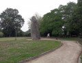
(S/E) From the car park, head straight into the town hall grounds, where the menhir from Caesar’s camp stands. Leave the grounds on the other side, following a path that runs behind the houses.
(1) You’ll come out onto Rue de la Pierre; turn left onto it. Stay on the road towards La Grignonnière and ignore all the roads on the right. Pass the hamlet of La Viollière on your right and you’ll soon reach a junction.
(2) Then turn sharply left.
(3) At the junction, cross the D19 and continue straight ahead onto a dirt track. At the next junction (marker 14), go straight on. At the following junction, at the hamlet of Les Aires, continue straight on. You will then reach the D105.
(4) Cross the road and first turn left then right onto a small tarmac road heading towards La Fontaine Saint-Gré.
(5) At the three-way junction just past the last houses, turn left and you’ll immediately reach La Fontaine Saint-Gré and its menhirs. Continue along the road for about a hundred metres, then turn right onto a path that starts with a stony section. It then winds its way through hedgerows to reach a junction of signposted paths.
(6) Take the wide path on the right. At the next junction, carry on straight ahead (green markings). This will take you to a tarmac road.
(7) Follow the road to the right. At the next junction, veer to the right then turn left to reach the beautiful mansion of La Mancelière.
(8) Then turn left and walk past the entrance to La Mancelière. Continue along the straight path lined with a hedge of trees. Further on, turn right onto the path and walk alongside a reservoir. At the end of the reservoir, continue straight on and head south-south-west until you reach a junction with the D91b at the entrance to the village of Le Bernard.
(9) Take thefirst path on the left at an acute angle. You will soon reach a junction.
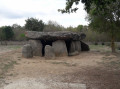
(10) Carry on straight ahead and you’ll immediately spot the Savatole Dolmens on your left.
(11) Retrace your steps.
(10) Back at the junction, turn right towards the Frébouchère Dolmen.
(12) At the car park, take a short detour to the left to admire the Dolmen de la Frébouchère.
(12) Continue north along the road. Ignore a road on the right, walk alongside the reservoir again and pass the hamlet of Le Ménil. You will then reach a junction.
(13) Carry on straight ahead along a dirt track lined with hedges. Cross the D949 (take care, as it’s a busy road) and head downhill.
(14) After about 300 m, turn left, wade across a stream and head uphill on the other side. Join a small road and follow it to the left. Ignore a farm track on the right and pass some silos on the right.
(15) Immediately afterwards, turn right. Pass under a high-voltage power line, return to the tarmac and pass the hamlet of Le Moulin de Boisseau. When the road turns left, carry on straight ahead along a track that runs alongside the farm buildings and leads to the junction (EARL La Croisée).
(16) Carry on straight ahead towards Beauchêne. Take thesecond road on the left, cross the D949 again with care and reach a junction you have passed before.
(6) Then turn right and pass the Boilière menhir on your right. Enter the village, come out onto Rue de la Fontaine and follow it to the right. Leave the industrial estate on your right and continue along Rue du Petit Saint-Jean. Cross Rue du Chêne and carry on straight ahead.
(17) At the end, turn right onto Rue du Bois Vilais. At the junction immediately ahead, turn left and then straight away right into Rue des Jardins. Walk up the street for about a hundred metres and turn right to reach the Avrillé market halls. Turn left, join Rue du Centre and follow it to the left.
(18) At the foot of the church, turn left into Rue Clemenceau and you will soon reach the starting car park (S/E).


 Visorando Member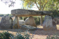

 Easy
Easy