Remollon: a hidden gem in the Durance Valley

Discover the treasures of Remollon, a village steeped in history and natural beauty. Nestled in a valley shaped by glaciers and the River Durance, this region offers the perfect setting for a family getaway. Go for a hike to admire unique sights such as the ‘petrifying’ waterfall, the fascinating ‘demoiselles coiffées’ rock formations, the majestic Remollon Dome from which the Saint-Roch Chapel rises, and the peaceful banks of the Durance.

Stroll through the narrow streets of the old town and immerse yourself in the rich and eventful history of this charming village, designated a ‘remarkable heritage site’. Let yourself be captivated by its rich wine-growing heritage and soak up its authentic atmosphere. Information panels featuring QR codes are dotted along the route, offering you an interactive and enriching experience. An invitation to explore and be amazed awaits you at every turn!

Details

68437733
Creation:
Last update:
Last review:
  • Walking
    Activity: Walking
  • ↔
    Distance: 3.80 mi
  • ◔
    Average duration: 2h 15 
  • ▲
    Difficulty: Easy

  • ⚐
    Back to start: Yes
  • ↗
    Ascent: + 604 ft
  • ↘
    Descent: - 617 ft

  • ▲
    Highest point: 2,598 ft
  • ▼
    Lowest point: 2,067 ft

Photos

Description of the walk

On arrival in Remollon, park your car in the Place de l’Hermitane.
Bus stop: “Remollon Mairie” –see Practical Information.

(S/E) To reach the Petrifying Waterfall, cross the road using the pedestrian crossing and head towards Gap until you reach the small car park on the left-hand side of the road just before you leave the village. Please take care, as you will be near a county road.

(1) Turn left onto the Chemin de la Waterfall to reach this geological curiosity.

(2) Turn back towards the waterfall car park. On the upper part of the wall on your right, near the car park, you can see a small plague cross carved into the stone – a particularly rare religious symbol in the department. See the ‘Nearby’ section below.

(1) Continue along the pavement towards the centre of Remollon, pass Place de l’Hermitane (on your left), then walk past the primary school and head for Place des Combettes.

(3) Cross at the pedestrian crossing and head up to the Parc du Bosquet. In summer, toilets and a water tap are available.
Continue towards the church, which can be seen a few metres away on the hill, and join Rue de l’Église.

(4) Built in the shape of a Latin cross, the Church of Notre-Dame de l’Assomption – which has no bell tower – is traditionally known as Notre-Dame des Victoires. Walk up Rue de l’Église, keeping the cemetery on your left. When the road ends, go round the water tank and follow the path to the Demoiselles Coiffées.

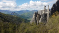
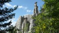
(5) As you pass by the base of these giant rock formations – also known as ‘fairy chimneys’ – take in the spectacle and the sweeping views over the village.
Head back the way you came, keeping to the left, pass by the museum car park, then turn left onto Rue des Templiers. Walk down to the junction with the departmental road and turn left towards Espinasses. You’ll then pass the Maison des Templiers (Town Hall) and the solitary bell tower before reaching the Maison du Vigneron.

(6) If it’s open, visit the museum, then retrace your steps and walk down Rue des Taillandiers to the Maison Méyère and its tower. Walk down Rue de la Bourgade to reach the Maison Claude Giraud, then turn right onto Rue des Seigneurs and admire the Porte aux Étoiles.

(7) Walk back up Rue de Compostelle, home to the Girard house. Continue to the right along Rue Lesdiguières until you see the tower of the old hospital. Walk down Rue du Général Colomb to Remollon Castle.

(8) Take Rue de la Bourgade, pass the Mauduech house, then carry on until you see the passageway on your right that runs beneath the houses. Head down Chemin de la Fontonne towards the plain and the orchards. After the hairpin bend, take the track branching off to your left and carry on until you reach the road. At the junction with the Chemin du Milieu, turn left and head for the Dôme de Remollon, on top of which stands the Saint-Roch Chapel.

(9) From the chapel, take in the sweeping panoramic view, then head back the way you came; at the junction, turn left and make your way to the peaceful banks of the Durance.
In summer, head down to the water’s edge and enjoy the cool water. Follow the riverbank to the ford.

(10) When the water level is low enough, you can cross the river and head to the three lakes of Rochebrune for a lovely swim.
Continue along the riverbank, then turn right onto the Chemin du Milieu. Ignore the tarmac road to L’Hermitane and take the Chemin des Combettes on your right, which climbs back up towards the village through the orchards. When you reach the main road, turn left and head for the Place de l’Hermitane (S/E).

Waypoints

  1. S/E : mi 0 - alt. 2,172 ft - Hermitane car park
  2. 1 : mi 0.25 - alt. 2,182 ft - Waterfall car park - Croix de peste
  3. 2 : mi 0.29 - alt. 2,149 ft - Cascade pétrifiante de Remollon
  4. 3 : mi 0.61 - alt. 2,175 ft - Place des Combettes – Chemin du Parc
  5. 4 : mi 0.73 - alt. 2,247 ft - Notre-Dame des Victoires Church – Rue de l’Église
  6. 5 : mi 1.18 - alt. 2,546 ft - Demoiselles coiffées (Remollon)
  7. 6 : mi 1.72 - alt. 2,192 ft - Maison du vigneron
  8. 7 : mi 1.81 - alt. 2,185 ft - The Gate to the Stars – Rue de Compostelle
  9. 8 : mi 1.91 - alt. 2,165 ft - Remollon Castle
  10. 9 : mi 2.64 - alt. 2,178 ft - Remollon Dome and Saint Roch Chapel
  11. 10 : mi 3.15 - alt. 2,073 ft - Banks of the Durance, ford leading to the three lakes
  12. S/E : mi 3.8 - alt. 2,172 ft - Hermitane car park

Notes

Bus: ZOU line, Sud region.

In summer, drinking water is available at Place de la Mairie and in the centre of the Parc du Bosquet.

In the village, you can quench your thirst and enjoy a bite to eat at the Trois Alpes snack bar and restaurant (Hautes-Alpes, Alpes-de-Haute-Provence and Alpes-Maritimes).

In summer, the Maison du Vigneron offers a free tour of the museum and a tasting of the excellent mountain wines, which have often won awards at the Paris General Agricultural Show.
On your left, if you’d like to enjoy your picnic or relax, you can head to the magnificent, shaded Parc du Bosquet, situated below the church.

Worth a visit

Further information is available on the Remollon website.

(1) The plague crosses: Wikipedia, and in particular the one in Romollon.

You can cool off at the ‘petrifying’ waterfall (1) at the western entrance to the village (car park 30 metres from the waterfall). Water from a major spring cascades down the hillside through an open channel, crosses the departmental road before reaching the Moulin district, where it once powered a grain mill. It forms the waterfall where the wooden channel that carried it to the mill’s wheel has now disappeared.
After flowing beneath the mill, it ends its journey in the Durance valley, plunging from the top of a tufa cliff. The water, laden with dissolved limestone and gypsum, creates petrifying fountains, which coat leaves, twigs or any object it touches with mineral deposits.

(4) Demoiselles Coiffées: these are also known as ‘fairy chimneys’. The Montagne des Assaillous, which overlooks the village to the north, features two major clusters of Demoiselles Coiffées (the western and eastern sites), comprising several dozen of these astonishing formations. Rain erosion has carved through the thick layer of clay-limestone soil and moraine boulders deposited by the Durance glacier, which cover the mountain’s flanks. As the rock blocks protect the ground immediately below them, erosion gradually clears the surrounding terrain, forming over the centuries these tall columns topped with their own rock.

In summer, the Maison du Vigneron (6) offers a tour of the museum and a tasting of the excellent mountain wines. Wine can be purchased on site.

We also recommend a visit to the Saint-Roch Chapel (14) at the eastern entrance, below the shopping area, which is easily accessible by car.
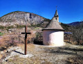
Perched on its rocky hillock, a little upstream from the village, the Saint-Roch Chapel overlooks the vast orchards of the Durance plain.
Its official name is actually Notre-Dame de Clémence, but popular tradition has retained only the name Saint-Roch, no doubt in memory of the circumstances that led to its construction.
In 1854, a terrible cholera epidemic that originated in Marseille decimated the population of Provence before spreading upstream along the Durance. It claimed many victims in the Embrun and Gap regions, but none in the village of Remollon, despite its high risk of exposure!

Reviews and comments

4 / 5
Based on 4 reviews

Reliability of the description
4.3 / 5
Ease of following the route
4 / 5
Route interest
3.8 / 5
dguincha
dguincha

Overall rating : 3.3 / 5

Date of your route : Jul 28, 2026
Reliability of the description : ★★★★☆ Good
Ease of following the route : ★★★★☆ Good
Route interest : ★★☆☆☆ Disappointing
Very busy route : No

There’s not much to see on this walk apart from ‘Les Demoiselles Coiffées’. There aren’t many sights to see in Remollon. What’s more, there’s a constant stream of cars and lorries on a street with narrow or non-existent pavements.

Machine-translated

Kicri
Kicri

Overall rating : 5 / 5

Date of your route : Apr 16, 2025
Reliability of the description : ★★★★★ Very good
Ease of following the route : ★★★★★ Very good
Route interest : ★★★★★ Very good
Very busy route : No

A lovely morning walk to explore the village, its chapel perched on the hilltop and the ‘coiffées’ rock formations. If you’re feeling a bit under the weather, head for Rémollon. If you’re feeling energetic, opt for the ‘fairy chimneys’ at Théus.

Machine-translated

Breolaise
Breolaise
• Edited:

Overall rating : 4 / 5

Date of your route : Feb 24, 2025
Reliability of the description : ★★★★☆ Good
Ease of following the route : ★★★★☆ Good
Route interest : ★★★★☆ Good
Very busy route : No

We couldn’t find the plague cross; it was probably hidden beneath the vegetation on the wall. Whenever we needed to change pavements, there was a pedestrian crossing to use. The problem is crossing the village of Remollon: there’s a lot of traffic – cars and lorries – on a narrow road with narrow pavements. It’s best not to go in a large group (3 or 4 people). The narrow streets are pleasant, cool and pedestrianised; walking through the orchards is peaceful, but be careful not to go on the walk on a day when the fruit trees are being treated.

Machine-translated

levequemi
levequemi

Overall rating : 3.7 / 5

Date of your route : Feb 16, 2025
Reliability of the description : ★★★★☆ Good
Ease of following the route : ★★★☆☆ Average
Route interest : ★★★★☆ Good
Very busy route : No

We got a bit lost in the village’s narrow streets – the sat-nav had stopped working – so we didn’t get to see everything that was described. Apart from that, the walk was varied and enjoyable.

Machine-translated

PapouBertrand
PapouBertrand

Hello, you’re quite right – this has absolutely nothing to do with Remollon.
This section must have been added by mistake by the moderator and slipped past my notice.
Thank you for pointing this out; the correction has been made.
Have a nice day

Machine-translated

diggi
diggi

In the practical information section, you state: “Walk 13.3.1: Lussolle (Losse) – Mouncaut Springs Route, organised by Rando-Landes.”
But what does this hike have to do with Remollon?

Machine-translated

Other walks in the area

For more walks, use our search engine .

The GPS track and description are the property of this route's author. Please do not copy them without permission.