Country:
 City:
City:


Park in the Terrasses car park, at the western end of Trestel beach.
(S/E) Leave the car park on the right and walk along the beach, with the sea on your left. Just before the rehabilitation centre, take the road uphill to the right. Ignore Rue des Prés on the left and, at the next Fork in the road, turn left onto Rue de Bel Air. At the next Fork in the road, continue to the right.
(1) Take a path on the left before reaching the road. At the end of the path, turn left then right to follow Rue de Min Guen. At a sharp right-hand bend, continue along the path that runs alongside the road. After 50m, turn right to walk alongside a lake on your left.
(2) Continue to the right. Follow Rue du Moulin for 30m and then take the path on the right.
(3) Turn left onto a path under the trees, heading north-north-west. Please note: this path is not shown on maps. It then turns north-west to run alongside a sewage treatment plant, then north until you reach some houses on the right. Continue to the left and join a street that leads to the Côte de Trestel. Carry on, keeping to the left.
(4) Take care when crossing Rue de la Mairie. Carry on to the right, then take the first left onto Rue de Ker Awell. At a sharp left-hand bend, carry straight on along the track. After a hairpin bend to the left, cross the Ruisseau de Kergouanton and carry on to the road leading to Rumorvan.
(5) Turn right. At the end of the street, turn left, then after 100 metres, turn right and continue to the left.
(6) If you turn right, you can head straight back to the car park where you started.
Carry on straight ahead. Take the footpath that continues from the street.
(7) At the fork in the road, turn left. Continue along Rue de Feunteuniou, then turn right into Rue de Port L’Épine. Walk down the footpath on the right-hand side of the street to reach the seafront.
(8) Turn left into Venelle de Porz Caroet. Continue alongside the campsite. When you reach the seafront, turn right. At the end of the campsite, turn right, go up the steps on the left and, once on the road, turn left towards the Village Marin. Continue along the seafront.
(9) Leave the road by taking a path on the right which leads to the viewpoint currently under development (winter 2017). An information board will soon be installed there. Unobstructed views of Tomé Island, Perros-Guirec Bay and, in the distance, the Sept-Îles Archipelago. On the way down, veer to the right and rejoin the road leading back to a junction you passed earlier.
(8) Continue along the seafront, passing a second campsite on your left. Join the coastal path and continue along it.
(10) Before the seafront turns left, take a path on the right.
(7) At the fork in the road you took on the way out, turn left to reach another junction you have already passed.
(6) Turn left onto Place Saint-Adrien, then onto Rue de Porz Keriec. Before reaching the beach, take the signposted path on the right. Continue along the coastal path. Cross the Ruisseau de Kergouanton again at its mouth and carry on to the headland.
(11) Walk round the headland and continue eastwards along Route de Port Le Goff. At the end of the road, turn left and head down towards the beach. After crossing the road, head for the Terrasses car park (S/E).

 ).
). Visorando Member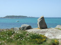
 Easy
Easy