Tonnay Suspension Bridge – Rochefort Transhipment Bridge

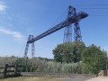
Starting from Rochefort, a short circular cycle route – with no particular difficulties – takes you across the Charente, first via the Tonnay-Charente pedestrian suspension bridge and then via the Rochefort transporter bridge

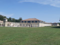
You’ll also pass through the area of the military arsenal commissioned by Louis XIV and cycle alongside the Corderie Royale.

Please note that the transporter bridge is closed during the winter months from November to March.

Details

n°23010894
Creation:
Last update:
Last review:
  • Mountain biking
    Activity: Mountain biking
  • ↔
    Distance: 13.68 mi
  • ◔
    Duration according to the author: 2.5 hrs 
  • ▲
    Difficulty: Easy

  • ⚐
    Back to start: Yes
  • ↗
    Ascent: + 98 ft
  • ↘
    Descent: - 98 ft

  • ▲
    Highest point: 85 ft
  • ▼
    Lowest point: -3 ft
  • ⚐ Country: France
  • ⚐ City: Rochefort (17300|17870)
  • ⚑
    Start/End: N 45.945304° / W 0.955945°
  • ❏
    IGN map(s): Ref. 1430OT, 1430SB

  • ◶
    Type of surface:
  •  
     
    ■ 40% Road ■ 60% Byway
  • ⇧
    Bike carrying: Not specified
  • ▲
    Difficulty: Easy
  • Hour-by-hour weather

Photos

Description of the route

The starting point is at the public car park next to the dance hall on Avenue William Ponty in Rochefort;

(S/E) Set off in the opposite direction to Avenue William Ponty, go through the gate in the town ramparts and turn left. Walk alongside ‘la vieille forme’ for a short while – the oldest dry dock in Europe, built under Louis XIV.
Turn left onto the wooden walkway overlooking the Charente at the foot of the ramparts (graffiti). Please note: this is a narrow walkway that ends with a step.

(1) After the step, head towards the swing bridge that closes off the entrance to the commercial harbour. Cross the bridge and continue along the cycle path on the left-hand side, separated from the road. The harbour is still in operation.

(2) About a hundred metres before the radio tower, turn right onto Rue de Fichemore. At the end of the street, cross the supermarket car park diagonally. Watch out for cars!
Leave the car park and follow the cycle path on the right, which is separate from the road. Cross the level crossing. Carry on straight ahead.

(3) At the roundabout, take the second right, then continue along the cycle path which goes uphill (still on the right and separate from the road) until you reach the next roundabout.

(4) Leave the busy road behind by continuing straight on down a street that leads into a residential area of Tonnay-Charente (cycle path marked on the road). Head down towards the centre of Tonnay.

(5) Before the roundabout, near the church, turn right onto Rue Bertrand Richard, follow it along the back of the buildings, then turn right and cross the level crossing. Near the Charente, turn left and follow the old quays of the port of Tonnay-Charente. A few cargo ships sometimes moor further downstream near the cranes.Enjoy the view of the suspension bridge and head towards it along the riverbank. Pass underneath it and turn left immediately at the roundabout.
A short but very tough climb (low gear, high gear ratio…) to reach the start of the bridge.
At the top of the hill, turn right and cross the bridge. There’s a lovely view of the surrounding countryside.
At the end of the bridge’s descent, take a sharp right-hand hairpin bend and head towards the Charente.

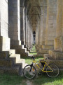
(6) Before turning left onto the small tarmac-surfaced Route de Marais, take a look under the bridge to see its distinctive ribbed vault architecture.
Drive along the small Route de Marais for about 2.5 km, cross two canals and reach a three-way junction.

(7) Carry on to the right towards La Chaboterie on a wider road, which is very well tarmac-surfaced and has very little traffic.

(8) Turn left and follow the canal.

(9) Ride past the Rochefort urban community’s water treatment plant, which looks a bit like a miniature Charente-style Guggenheim.
Continue for a further 3.5 km or so, cross the Gardette Canal (signposted) and ride past the hamlet of Les Grèves on your left.

(10) After the hamlet of Les Grèves, at the bend where the road curves to the left, take the path leading uphill to the right (there’s no signpost in this direction, but there is a cycle route sign in the opposite direction). Enter the Renaissance district via Rue du Tonkin.

(11) At the end of the street, turn right and, at the roundabout, turn right again towards the Martrou Transporter Bridge, visible in the distance. Continue right at the next junction, onto Rue du Transbordeur, and reach the bridge. Make a return trip to the right to collect your tickets at the Musée des Ponts (which can be visited free of charge).

(12) On your return, cross the transhipment bridge then turn right onto the path that runs alongside the Charente to the three dry-docking slips (Napoleon III and Louis XV).

(13) Go round them on the left and return to the path along the banks of the Charente.

(14) Walk past the Corderie Royale and then along the Charente, keeping straight on.

(15) Cross the lock that closes off the marina via the footbridge. If the lock is open, go round the basins on the left, but it won’t stay open for long.
Follow the Charente and return to the starting point via the Vieille Forme (S/E).

Waypoints

  1. S/E : mi 0 - alt. 13 ft - Car park – Avenue William Ponty
  2. 1 : mi 0.22 - alt. 13 ft - Swing bridge at the entrance to the commercial harbour - Charente (fleuve)
  3. 2 : mi 0.65 - alt. 13 ft - Rue Fichemore
  4. 3 : mi 1.52 - alt. 20 ft - First roundabout
  5. 4 : mi 2.49 - alt. 82 ft - Second roundabout
  6. 5 : mi 3.36 - alt. 33 ft - Église Saint-Étienne (Tonnay)
  7. 6 : mi 4.62 - alt. 13 ft - Under the suspension bridge
  8. 7 : mi 6.2 - alt. 16 ft - La Chaboterie
  9. 8 : mi 6.59 - alt. 13 ft - Canal de la Charente à la Seudre
  10. 9 : mi 7.2 - alt. 10 ft - Water treatment plant
  11. 10 : mi 9.18 - alt. 16 ft - Entrance via Chemin Blanc
  12. 11 : mi 10.12 - alt. 26 ft - Junction, turn right
  13. 12 : mi 10.77 - alt. 16 ft - Transhipment bridge
  14. 13 : mi 12.63 - alt. 16 ft - Types of dry dock - Hermione
  15. 14 : mi 12.99 - alt. 13 ft - Corderie Royale
  16. 15 : mi 13.36 - alt. 13 ft - Lock
  17. S/E : mi 13.68 - alt. 13 ft - Car park – Avenue William Ponty

Notes

Throughout the route, you’ll follow cycle paths separate from the road or very, very quiet marshland tracks. The route is suitable for young children (though it is 20 km long).

Check before setting off that the transporter bridge is operating (closed from November to March and occasionally for maintenance).

If the swing bridge at the commercial harbour is open, you may be lucky enough to witness a cargo ship making a spectacular entry or exit. Otherwise, you can cycle around the harbour (+ 2 km).

There is a charge to cross the transporter bridge: €2 per adult in 2022.

Worth a visit

Tonnay Charente Bridge: the first bridge, built in 1842, collapsed during a load test in 1883. Rebuilt in 1884, its current form (a suspension bridge) dates from 1934. It remained in service until the construction of the Saint Clément Bridge further upstream in 1964.

The Rochefort transporter bridge, built by the engineer Ferdinand Arnodin, came into service in July 1900. It is the last structure of its kind still in operation in France.

The Corderie Royale, 374 metres long and 8 metres wide at its narrowest point. Its construction began in 1666 under Louis XIV. It was almost entirely destroyed by a fire that lasted several days following the withdrawal of the occupying forces in 1944. Renovation work began in 1973. It remained in service until 1862, producing ropes for the Royal Navy.

Reviews and comments

4.3 / 5
Based on 2 reviews

Reliability of the description
4.5 / 5
Ease of following the route
4.5 / 5
Route interest
4 / 5
Gillou79
Gillou79

Overall rating : 4.7 / 5

Date of your route : Aug 19, 2024
Reliability of the description : ★★★★★ Very good
Ease of following the route : ★★★★★ Very good
Route interest : ★★★★☆ Good
Very busy route : No

It was a peaceful route, apart from in Tonnay Charente, but a local woman suggested we take some alternative routes to find a quieter spot.

Machine-translated

filiplacour
filiplacour

Overall rating : 4 / 5

Date of your route : May 01, 2023
Reliability of the description : ★★★★☆ Good
Ease of following the route : ★★★★☆ Good
Route interest : ★★★★☆ Good
Very busy route : No

The section that goes through Tonnay-Charente is in town and not great, but there’s no alternative; the rest is nice on both sides

Machine-translated

Other walks in the area

For more walks, use our search engine .

The GPS track and description are the property of this route's author. Please do not copy them without permission.