Country:
 City:
City:


Park in the Pradelle Castle car park. Public toilets are available at the far end of the car park, at the entrance to Pradelle Park.
(S/E) With your back to the car park, turn left onto Chemin Saint-André (on the GR®42, marked with white and red signs). Cross the bridge over the railway line and continue along this road.
(1) At the road bridge, look out for the steps on the right, which you’ll take on the way back. The road turns into a path and passes under the road bridge. You’ll then catch a glimpse of Bellevue Castle on the left; stay on the GR®42.
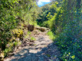
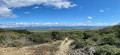
(2) After passing a few houses, take the track on the left, by the transformer, to cross to the other side of the stream onto a wide path which turns into a footpath. After about 1 km of a steady climb, enjoy a beautiful view of the Rhône Valley. Keep to the left, passing several houses, until you reach a tarmac road. Turn right onto it for a few metres.
(3) At the “Darbousset” signpost, leave the GR® and take the PR®, following the white/yellow markings to the left towards the Sentier Botanique. Continue along this wide path. At the Fork in the road, keep left to stay on the main path. After a left-hand bend, continue to the right (follow the markings).
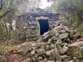
(4) At the signpost, follow the sign for “Croix de Romanet” to the right, walking alongside a vineyard. A little further on, you’ll come across your first drystone shelter on the left, somewhat hidden by the vegetation, with an information board. Continue behind the drystone shelter along the path between the vineyard and the trees, then straight ahead alongside the vines. At the end of the vineyards, head up to the right onto the embankment which leads into the woodland. Enjoy the panoramic view over the Rhône Valley, the Dentelles de Montmirail, Mont Ventoux, the Provençal Baronnies and the Montagne de la Lance.
(5) You’ll come to another drystone shelter; head left, then left again onto the path running above it. Walk briefly alongside a valley without descending into it. When the path emerges from the woods and joins the farm track you were on earlier, follow the signposted path to the right. In an open area, you’ll come out onto a wider path; continue to the right. At the signpost marked ‘Sentier Botanique’, keep to the right. When the path turns left, ignore a fork to the right, pass in front of a hunting hide, then take the first path on the left.
(6) After about 200 m, turn left into the woods and you’ll come to a beautiful drystone shelter with a dry-stone bench at the entrance. Go round the back of this drystone shelter to reach a track and discover a fourth one, directly opposite. Continue along this track to the right, then turn left when it crosses the Sentier Botanique.
(4) You’ll come across the signpost you passed on the way out; follow the route you took on the way out in the opposite direction until you reach the road bridge you crossed earlier.
(1) Go up the steps on the left to reach Avenue Albertine Maurin. Take the bridge on the right. Turn left onto Avenue de Lattre de Tassigny, then left onto Rue des Tanneries Amblard, which descends steeply, passes under the railway lines and crosses the bridge over the Ruisseau de Tourne.
(7) Walk round the 19th-century washhouse (information panel) to descend to the left into the Tourne valley and reach the resurgence (world-renowned for underground caving) and the bas-relief dedicated to the god Mithra. (There are two information panels to read). Then head back up to the right through Parc Pradelle. A display stand overlooking the valley provides an overview, including a history of the site and photos of the two resurgences where the water overflows. Return to the car park where you started (S/E).
 Visorando Member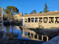

 Moderate