Country:

 City:
City:


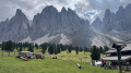
To get to the start point in Zans, cross the bridge and head for the car park to the south-west of the hamlet.
(S/E) At the western end of the car park, go through the barrier and follow the track until you reach a path on the left.
(1) Take this path and head through the woodland to the next junction.
(2) Turn left and climb up to a bar. Continue along the access path to the bar until you reach a three-way junction. Turn left and, at the next three-way junction, keep right. Go through the gate and you’ll soon find a single track on the right.
(3) Follow this track until you reach a fork at a bridge.
(4) Turn right onto the bridge and you’ll reach a track suitable for vehicles. Turn left, pass the mountain hut and head for the next one.
(5) Continue along the path (normally signposted) which is on the left behind the bar. Climb up, then descend steeply to reach a junction (Adolf Munkel Trail).
(6) Carry on downhill to the left. At the next fork, head right, go round a hairpin bend to the left and you’ll reach a rock with a sign explaining everything (if you understand German, of course).
(7) Carry on straight along the path until you reach the stream (this section of the trail is now over). Take the track to the right, cross the bridge and, on your left, you’ll find a small, unobtrusive single track under the trees.
(8) Follow it down to the bottom of the valley until you reach a track. Turn left, cross the bridge and head straight on until you reach the car park (S/E).


 Visorando Member
 Easy
Easy 

 Difficult
  Very difficult