Country:

 City:
City:


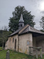
Park in the car park of the CNRS CAES chalet near the village of La Basse de Martimpré.
(S/E) Take the road downhill to the left, following the Red Disc signs; continue straight on at the Places crossroads and then head towards the Sainte-Anne Chapel
(1) Carry on straight ahead, still following the Red Disc markings, until you reach the Nayemont crossroads.
(2) Leave these markings here, turn right and follow the wide path marked with Yellow Triangles. Head for La Chaume de Nayemont.
(3) From here, begin a gentle descent to reach a crossroads with several routes.
(4) Head straight ahead (north) along the Route Forestière de Clairsapin, marked with a Yellow Triangle, and at the next crossroads, keep straight ahead to reach the Tête de Nayemont path very quickly.
(5) Here you can reach the summit by taking a circular route to the left along the path marked with a Blue Cross (unmarked). Continue on to the Clair Sapin Centre.
(6) Here, leave the Yellow Triangle markings and head down to the right along a lovely path to join a small road, marked with a Red Triangle, before the hamlet of Les Collieures.
(7) Turn right onto this road, cross the Collieures campsite, then turn right, following these markings. You’ll reach the Rayrand Stream.
(8) Cross the Pont des Trois Communes bridge and continue to the left to reach the hamlet of Stousmey.
(9) Turn right heading due south, following the ‘Blue Cross’ signposting up a gentle slope along a magnificent tree-lined path until you reach a three-way junction.
(10) Carry on straight ahead along the road to reach the car park at the CNRS chalet (S/E).

 Visorando Member
 Difficult
 Moderate
 Very difficult