


 Country:
 City:


The start is in the car park on Rue de la Libération, near the cemetery (on the outskirts of the village heading towards Francheville).
(S/E) Head down the D10A towards the village and take thefirst street on the left (Allée des Tilleuls). Walk past the cemetery and continue along Rue des Bises.
(1) Take the path on the left after number 36.
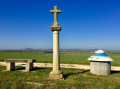
(1) Carry on straight ahead for about 1 km. On the path, pass the Croix de Jaillon and ignore the turnings to the left.
(2) At the sharp left-hand bend, turn right onto the path running along the edge of the woods, and follow it as it winds several times to the right and left. Leave the edge of the woods and continue to the right along a straight path until you reach the En Champot crossroads.
(3) Turn left and head down to the small bridge.
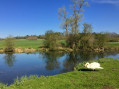
(4) As you come off the bridge, enter the meadow on the right (sometimes fenced off for sheep, but don’t hesitate to step over the fence). Walk alongside the River Terrouin and leave the meadow through the metal gate. Take the road on the right to cross the bridge over the River Terrouin. At the end of the bend after the bridge, follow the cycle path on the left which leads to the canal.
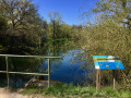
(5) Pass the footbridge on your left whilst continuing along the cycle path (Voie Verte) towards Villey-Saint-Étienne. Walk alongside a lagoon treatment area.
(6) After about 1.8 km, take the path on the right leading to the steps.
(7) At the top of the steps, turn left into Rue Bellevue and walk to the church. Note: there is a viewpoint overlooking the Moselle to the left of the church steps.
At the foot of the church steps, turn right onto Rue de l’Église and continue to the ‘Stop’ sign. Turn left onto Rue de Liverdun, then immediately right to rejoin Rue de la Libération. Continue straight on to reach the starting point on the right after Allée des Tilleuls (S/E).

 Visorando Member
 Moderate

 Difficult

