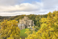
The two church towers in Montpinchon

In the lush countryside of the Savigny bocage, follow in the footsteps of history. As you walk, try to catch a glimpse of Savigny’s bell tower and listen carefully: the old stones have stories to tell.

Details

n°15866113
Creation:
Last update:
Last review:
  • Walking
    Activity: Walking
  • ↔
    Distance: 11.25 mi
  • ◔
    Average duration: 5h 40 
  • ▲
    Difficulty: Difficult

  • ⚐
    Back to start: Yes
  • ↗
    Ascent: + 607 ft
  • ↘
    Descent: - 617 ft

  • ▲
    Highest point: 469 ft
  • ▼
    Lowest point: 141 ft

Photos

Description of the walk

Park in the church square.

(S/E) Head straight on, join the D73 and turn left towards L’Hôtel Hébert. Take the first road on the right and continue straight on to La Haye.

(1) Turn left onto the D252 as far as La Prioudière.

(2) Take a small path on the right towards the hamlet of Durand. Once there, turn right onto a path leading to the Petit Château.

(3) Turn left onto a path towards La Sauvagère, cross through the hamlet to join a path running alongside the stream of the same name as it heads towards La Grande Gaublotière.

(4) On the outskirts, as you leave the path, turn right towards La Pesnerie. Cross a road, pass through the hamlet and continue along the road. Turn sharply left, pass under a power line and continue to L’Hôtel Coupeaux.

(5) Turn left, join the D302 and follow it to the right until you reach the junction just before Les Planches. Here, turn left and then left again. Cross the D99 and carry on straight ahead towards L’Hôtel La Lande, which you’ll pass on your left.

(6) Cross the Ruisseau du Vesly, pass through the village of La Louelle, where you turn left onto the D302. At the crossroads after La Landerie, turn right onto the departmental road leading to Savigny.

(7) Ride past the square in front of Savigny church and continue straight on along the Route du Manoir (D302).

(8) Cross the D52 and carry on to the village of Besnard.

(9) After passing a wayside shrine, turn right, cross the Ruisseau du Pont and continue along the narrow paths leading to La Villederie.

(10) On leaving this hamlet, leave the road and take a short path on the right before turning right onto the paths leading to Moulin de la Prairie. Follow the Route de la Croix Périer to the D52.

(11) Turn left onto the D52 towards La Maison Neuve. On this road, take the first path on the right towards Le Hameau Esnée, where you should turn left to rejoin the D99.

(12) On this road, turn right and then left towards Le Hameau Villedieu. Take the path that starts there and leads onto the D252 on the outskirts of Le Hameau au Seney.

(13) At the end of the path, turn right towards Le Castel. At the bend, leave the D252 and head towards La Robinière.

(14) Before you reach it, turn left onto paths heading towards La Vionnière. With your back to this hamlet, turn left, cross over the Ruisseau de la Sauvagère and turn left onto a path leading to the D252. First turn right then left to head towards La Vauterie.

(15) In the hamlet, turn right onto a path leading to the D102. Turn left and walk alongside the Champ du Vage.

(16) Walk through the village of Le Pavage and turn left towards Montpinchon until you reach (S/E).


Waypoints

  1. S/E : mi 0 - alt. 469 ft - Place de l’ - Église Notre-Dame de l'Assomption (Montpinchon)
  2. 1 : mi 0.91 - alt. 315 ft - La Haye
  3. 2 : mi 1.37 - alt. 289 ft - La Prioudière
  4. 3 : mi 1.8 - alt. 305 ft - Petit Château
  5. 4 : mi 2.6 - alt. 164 ft - La Grande Gaubotière
  6. 5 : mi 3.3 - alt. 217 ft - The Hôtel Coupeaux
  7. 6 : mi 4.18 - alt. 154 ft - The Vesly stream
  8. 7 : mi 5.1 - alt. 328 ft - Église Notre-Dame (Savigny)
  9. 8 : mi 5.72 - alt. 276 ft - D52 road
  10. 9 : mi 6.14 - alt. 292 ft - Village of Besnard
  11. 10 : mi 6.63 - alt. 335 ft - La Villederie
  12. 11 : mi 7.16 - alt. 266 ft - D52 road
  13. 12 : mi 7.79 - alt. 341 ft - D99 road
  14. 13 : mi 8.44 - alt. 400 ft - Hamlet at Le Seney
  15. 14 : mi 8.83 - alt. 371 ft - La Robinière
  16. 15 : mi 9.8 - alt. 344 ft - La Vauterie
  17. 16 : mi 10.61 - alt. 413 ft - The Pavage
  18. S/E : mi 11.25 - alt. 469 ft - Place de l’ - Église Notre-Dame de l'Assomption (Montpinchon)

Notes

Yellow signposting.

Difficulty: none, apart from the distance.
A pub with a bread collection point in Montpinchon.
Public toilets in Savigny and Montpinchon, next to the church.
Water points in the cemeteries.
Shelter and picnic tables in Savigny.

Worth a visit

Points of interest
The village of Le Castel in Montpinchon is mentioned, as a fief, in a deed dated 7 September 1313, specifying a land rent of 2 bushels of grain, 40 sols and 9 deniers. From 1505 until the Revolution, members of the Leseney family held the fief. The building situated by the roadside appears to be the oldest, despite a stone dating from the 17th century. The masonry is made of phyllade (schist) from Saint-Lô and appears to date from the 14th–15th centuries.

The Château de la Salle
It is a composite complex comprising the Chapel of Saint-Julien (14th–15th centuries), alongside a remodelled 15th-century building, of which a tower on the north side has been levelled. To the right stands an imposing building constructed of red schist, built by the Martel family, whose coat of arms can be seen on one of the lintels (15th–16th centuries). The château was built by Louis, Marquis de Caillebot de la Salle, in the early 18th century.

The Landerie Manor House
Situated at the crossroads between Savigny, Belval and Ouville, the 17th-century Landerie de Bas manor house offers a lovely view for walkers. This beautiful building has been faithfully restored by its current owners.

Savigny Church
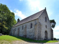
This church dates from the 12th century. The chancel and apse (1128) are Romanesque in style. Its porch dates from the 17th century. On the north wall, you can admire its 14th-century murals depicting the Last Supper. Behind the altar, you’ll find murals depicting the martyrdom of Saint Barbara, also from the 14th century. Outside, you’ll love the carved modillions on the cornices all around the church, which undergoes regular restoration work. The Association for the Preservation of Savigny Church organises concerts there to fund these works.

Reviews and comments

3.7 / 5
Based on 2 reviews

Reliability of the description
4 / 5
Ease of following the route
3 / 5
Route interest
4 / 5
Coutances Tourisme
Coutances Tourisme

Hello,

Thank you very much for your feedback. The maintenance team are currently out clearing the paths. All the paths will be cleared within a month. We apologise for any inconvenience caused. The Tourist Office

Machine-translated

User 25665923

Overall rating : 3.7 / 5

Date of your route : May 22, 2025
Reliability of the description : ★★★★☆ Good
Ease of following the route : ★★★☆☆ Average
Route interest : ★★★★☆ Good
Very busy route : Yes

A lovely route, but the paths need a good clear-up.
Had to turn back between point 12 and point 13 (in the hamlet of Villedieu) after just 10 metres – too much tall grass and the path was flooded.
Otherwise, a pleasant and peaceful route.

Machine-translated

Noirval
Noirval

Overall rating : 3.7 / 5

Date of your route : May 04, 2023
Reliability of the description : ★★★★☆ Good
Ease of following the route : ★★★☆☆ Average
Route interest : ★★★★☆ Good
Very busy route : No

Not all the paths are well-maintained; there are some difficult sections.
There are many very damp sections.
However, a lovely walk through the Manche countryside!
The pub in Montpinchon is closed

Machine-translated

Other walks in the area

For more walks, use our search engine .

The GPS track and description are the property of this route's author. Please do not copy them without permission.