The Stations of the Cross starting from Saint-Lézin

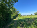
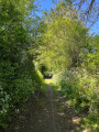
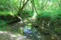
Set amidst unspoilt hedgerow countryside, crosses and wayside shrines mark your idyllic stroll around Saint-Lézin.

Details

n°3515883
Creation:
Last update:
Last review:
  • Walking
    Activity: Walking
  • ↔
    Distance: 7.98 mi
  • ◔
    Average duration: 3h 45 
  • ▲
    Difficulty: Moderate

  • ⚐
    Back to start: Yes
  • ↗
    Ascent: + 102 ft
  • ↘
    Descent: - 112 ft

  • ▲
    Highest point: 390 ft
  • ▼
    Lowest point: 292 ft

Photos

Description of the walk

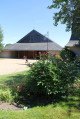
Park near the modern church of Saint-Lézin. Follow the yellow markings.

(S/E) Walk through the Espace des Gogannes, a lovely grassy meadow, and follow it until you reach the tarmac road.

(1) Turn left onto Rue du Val d’Aubance. Cross it, keeping slightly to the right, and take Chemin des Fontaines, which joins Chemin du Bois, where you turn left. Turn right, then right again at the junction towards La Gachetière.

(2) At La Gachetière, turn right and then immediately left onto the D199. You’ll come to a Y-junction with a cross; this is the Calvaire du Cramail. Take the left-hand road, which leads to another multi-way junction, also marked by a cross.

(3) Ignore all the roads here and turn left onto the Chemin du Bois. Continue along this tree-lined path until you reach the crossroads in the hamlet of La Basse Clerjauderie.

(4) Turn right, pass through the hamlet of Haute Clerjauderie, carry on and you’ll come to another Y-junction.

(5) Turn onto the path on the left and, at the junction by the small stream, keep to the right. Join a road and turn left onto it to reach the hamlet of Pinier.

(6) Carry on straight ahead until you reach the D149, turn left and then immediately right as you cross it. Continue on, crossing the Ruisseau de l’Aubance at Landes Gontard. At the T-junction, take the path on the left, then at the next crossroads by the wayside cross, turn right to reach the hamlet of Les Noues.

(7) Pass the farm and turn left after going under the power line, then reach the hamlet of La Richaudière.

(8) Carry on straight ahead to the cross, then join the D349. Cross the road here to reach the Cramaillère farms.

(9) Carry on past the Rousselière farms. At the junction with the next road, turn left and pass through the hamlet of La Blottière. Continue along the paths through the fields until you reach a T-junction.

(10) Turn right at a 90° angle, pass the houses at Les Lambarderies, then turn left again at a 90° angle to enter Saint-Lézin and reach the church car park (S/E).

Waypoints

  1. S/E : mi 0 - alt. 312 ft - Car park near the modern church
  2. 1 : mi 0.14 - alt. 308 ft - After the stream, turn left
  3. 2 : mi 1.29 - alt. 328 ft - La Gachetière
  4. 3 : mi 1.5 - alt. 331 ft - Crossroads: path marked by a cross
  5. 4 : mi 2.1 - alt. 348 ft - La Basse Clerjauderie
  6. 5 : mi 2.45 - alt. 338 ft - Y-junction
  7. 6 : mi 3.11 - alt. 384 ft - Le Pinier
  8. 7 : mi 4.37 - alt. 358 ft - Les Noues
  9. 8 : mi 4.71 - alt. 358 ft - La Richaudière
  10. 9 : mi 5.65 - alt. 348 ft - La Cramaillère
  11. 10 : mi 7.03 - alt. 348 ft - Crossroads towards Les Lambardières
  12. S/E : mi 7.98 - alt. 312 ft - Car park near the modern church

Worth a visit

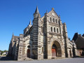
Modern Church of Saint-Lézin:
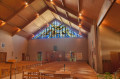
The old church, built in 1875, was severely damaged by a tornado in 1978. It was decided to demolish it and build a modern church in its place, simple in design, with a low bell tower nearby. It was consecrated in 1981.

Reviews and comments

4 / 5
Based on 2 reviews

Reliability of the description
4 / 5
Ease of following the route
4 / 5
Route interest
4 / 5
elopez7228
elopez7228

Overall rating : 4.3 / 5

Date of your route : May 10, 2024
Reliability of the description : ★★★★☆ Good
Ease of following the route : ★★★★★ Very good
Route interest : ★★★★☆ Good
Very busy route : No

Flat terrain, perfect weather. A very pleasant walk, although a little monotonous. I’d have liked to come across some streams and see a bit of variety in the scenery now and then. The circular route takes you across wide open plains, sometimes lined with trees. The route was well signposted, apart from one specific point where you need to follow the map rather than the signposts or directions.

Machine-translated

Fouché
Fouché

Overall rating : 3.7 / 5

Date of your route : Nov 19, 2022
Reliability of the description : ★★★★☆ Good
Ease of following the route : ★★★☆☆ Average
Route interest : ★★★★☆ Good
Very busy route : No

Several road signs are missing, particularly at junctions. There is a sign pointing in the wrong direction which is actually in the right direction.

Machine-translated

Other walks in the area

For more walks, use our search engine .

The GPS track and description are the property of this route's author. Please do not copy them without permission.