Country:
 City:
City:


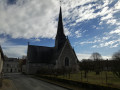
Start in the Old Town of Saint-Étienne-de-Chigny (not to be confused with Saint-Étienne-de-Chigny Pont de Bresme), in the car park opposite the church, in front of the signpost for the walk.
(S/E) With your back to the church, head north up the main street (D126). Ignore the first path on the right (green hiking sign – do not follow) and continue to the second dirt track just before the ‘end of built-up area’ sign (wider). Take this track to the right and follow it to the small tarmac road.
Turn left until you cross the D126, heading towards the left (watch out for traffic, which is light)
(1) Take the uphill road immediately on the right.
(2) At the top of the climb, at the Fork in the road, take the right-hand path (you can turn left for a shortcut avoiding the forest).
At the "Le Clos" house, turn right just in front of the property (between the main building and the woodpile) to enter the forest. Follow the path, which curves naturally to the left.
(3) At the T-junction, turn left. At the next junction, turn right towards the "Les Bodinières" housing estate, cross the first street and continue straight on (Chemin des Ruches). Continue to the end of the cul-de-sac
(4) Continue along the small dirt track that goes downhill (sometimes quite steeply, so take care).
Once you reach the road (Route de Mazières de Touraine), turn left onto it and follow it downhill back to the starting point (S/E)



 Visorando Member


 Moderate