Sey Mill from Trelly

Along the banks of the Sienne, you’ll enjoy this route, which takes you along numerous shaded paths. What’s more, your route is dotted with relics of the past: wayside crosses, a chapel, an old village and even an old mill. An unmissable walk in the Coutances area.

Details

n°15934495
Creation:
Last update:
Last review:
  • Walking
    Activity: Walking
  • ↔
    Distance: 9.32 mi
  • ◔
    Average duration: 4h 30 
  • ▲
    Difficulty: Moderate

  • ⚐
    Back to start: Yes
  • ↗
    Ascent: + 262 ft
  • ↘
    Descent: - 269 ft

  • ▲
    Highest point: 200 ft
  • ▼
    Lowest point: 39 ft
  • ⚐ Country: France
  • ⚐ City: Trelly (50660)
  • ⚑
    Start/End: N 48.959922° / W 1.427905°
  • ❏
    IGN map(s): Ref. 1313O, 1314O
  • Hour-by-hour weather

Photos

Description of the walk

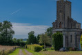
Parking near the cemetery and Trelly church.

Yellow signposting.

(S/E) With your back to the church, turn right then take the first street on the left towards Le Coisel.

(1) At the Huguenoterie junction, carry on straight ahead.

(2) Before reaching Le Coisel, turn right towards the Chapelle des Ermites, then right again towards the Hôtel Bouillon. Continue to La Germinière and, at the end of the road, take the path branching off to the left towards the D349. Once on this road, turn left.

(3) Follow the D349 to the right, then, at the junction, take the left-hand road towards La Croix des Touches. At this point, turn onto the path on the right and continue towards Le Petit Launay. Cross the small road to stay on the path and eventually reach the D49.

(4) Turn right onto this road and head towards Le Pont Cé. Then turn left onto the footpath towards La Fissoterie. At the end of the footpath, turn left and continue straight ahead along the road, then take the footpath towards La Pérotterie.

(5) At the end of the path, turn right towards Le Clos des Barrières and La Godefrairie. Walk straight on and join the path that starts at the next bend. Walk straight on, ignoring the junctions, towards Le Hamel Février.

(6) When you come to the end of the path, turn right and then immediately left onto the small road. At the next junction, turn right and walk to La Rousserie. From there, take a path that turns right towards Torvet. Continue straight on to join the D35.

(7) Turn right, passing through La Hersoterie and Le Clos Birx in turn, then take the first path on the left towards Saint-Louet.

(8) At the end of the path, turn right towards La Champrepuserie, crossing the D35 with care, and, at the end of the road, take the path leading to La Croix Berel. From there, turn left onto the road and then left again onto the path leading to L’Orangerie.

(9) Once on the road, turn left to rejoin the D35. Cross this road carefully and head towards La Petite Écaudeville, then continue towards La Brégeauderie. Cross the railway line and head towards Le Moulin de Sey and Écaudeville, thus rejoining the D35.

(10) Turn left onto this road and, at the next junction, cross the road carefully to continue straight on along the D235. Then take the first right onto a small road. Take the footpath that starts at the end of this road towards La Huguenoterie.

(1) At the junction, turn right to reach the village of Trelly. Once on the D49, turn right to return to the church square (S/E).

Waypoints

  1. S/E : mi 0 - alt. 141 ft - Place de l’ - Église Saint-Germain (Trelly)
  2. 1 : mi 0.37 - alt. 118 ft - Junction of the circular loop
  3. 2 : mi 0.62 - alt. 89 ft - Turn-off towards the Chapelle des Ermites
  4. 3 : mi 1.51 - alt. 151 ft - D349 road
  5. 4 : mi 2.43 - alt. 141 ft - D49 road
  6. 5 : mi 3.14 - alt. 197 ft - La Pérotterie
  7. 6 : mi 3.76 - alt. 157 ft - Le Hamel, February
  8. 7 : mi 4.82 - alt. 108 ft - D35 road
  9. 8 : mi 5.39 - alt. 89 ft - Saint-Louet
  10. 9 : mi 6.61 - alt. 157 ft - The Orangery
  11. 10 : mi 8.07 - alt. 128 ft - D35 road
  12. S/E : mi 9.32 - alt. 144 ft - Place de l’ - Église Saint-Germain (Trelly)

Notes

Difficulty: the route crosses the D 35 several times

Public toilets near the church and behind the town hall
Picnic tables at Sey Mill and the sports centre
Local shops

Worth a visit

Point of interest – The Sienne
As you pass the Sey Mill, you’ll come across the Sienne: this coastal river, which flows into the Regnéville Harbour, is a gathering place for long-distance migratory birds. In autumn, Atlantic salmon leave the sea and swim upstream to spawn. It is at this time of year that the pale-bellied brant goose, arriving from the Nordic countries, takes up winter quarters on the salt marshes of Regnéville Harbour. In summer, sea lampreys and river lampreys (jawless fish with a sucker) in turn gather at the spawning grounds on the River Sienne. Finally, let us not forget the eel, which colonises the freshwater of the catchment area after a long journey from its breeding grounds in the Sargasso Sea.

The ruins of the Sey Mill
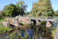
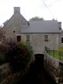
Take a stroll through this peaceful spot, which invites you to relax. This site, with its untamed charm, offers glimpses of the bell tower of the village of Quettreville-sur-Sienne through the hedgerows. The former mill can be made out thanks to the remaining ruins. Built before the Revolution of 1789 and demolished in 1957, it was of great importance to the region, with its two water wheels mounted on each gable. Today, a footbridge spans the River Sienne above the ruins, linking the villages of Trelly and Quettreville-sur-Sienne. The site has now been developed to welcome visitors and for fishing in the River Sienne.

Saint-Louet
Saint-Louet-sur-Sienne is a former commune in the area, near the circular meanders of the River Sienne. During the Revolution (1794–1795), it was incorporated into the commune of Trelly at the request of its inhabitants. Today, the remains of the old 9th-century church can still be seen in this hamlet, thanks to its bell tower which still stands in the heart of the bocage.

The Hermits’ Chapel
Built in 1903 by Madame de Bérenger, owner of Trelly Manor, this chapel is dedicated to the Black Madonna of Einsiedeln, housed in a monastery in German-speaking Switzerland. The chapel stands on private land but can be seen from the route.

Reviews and comments

4 / 5
Based on 2 reviews

Reliability of the description
4 / 5
Ease of following the route
4 / 5
Route interest
4 / 5
alge
alge

Overall rating : 3.7 / 5

Date of your route : Jun 24, 2023
Reliability of the description : ★★★★☆ Good
Ease of following the route : ★★★★☆ Good
Route interest : ★★★☆☆ Average
Very busy route : No

I can confirm, as mentioned in the previous review, that we are still unable to continue the walk at the hamlet known as Le Petit Launay (4). The path is blocked in several places by wires. We have to turn back and rejoin the path at the hamlet known as La Frissoterie.

Machine-translated

Karsenti
Karsenti

Overall rating : 4.3 / 5

Date of your route : Mar 13, 2022
Reliability of the description : ★★★★☆ Good
Ease of following the route : ★★★★☆ Good
Route interest : ★★★★★ Very good
Very busy route : No

At La Croix des Touches, the path on the right is not passable all the way to the end; you cannot reach Le Petit Launay or the D49. Turn back towards the château and the next junction, cross the D49 towards La Fissoterie, and rejoin the route on the road to the right.

Machine-translated

Other walks in the area

For more walks, use our search engine .

The GPS track and description are the property of this route's author. Please do not copy them without permission.