


 Country:

 City:
City:


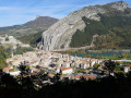
The route starts from the Sisteron Tourist Office: bus stop and car park at Place de la République.
(S/E) With your back to the town hall, turn right onto Avenue des Arcades. Turn left to cross the small car park and join Avenue Jean Moulin. Turn left.
(1) Just before the police station, turn right onto the Montée du Molard. Go round the children’s playground and continue along the botanical trail, which winds its way up several bends.
(2) At the first junction, keep left on theGR®6towards the Molard orientation table. Continue to a junction with communications masts.
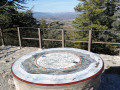
(3) Turn right and you will soon reach the Molard Refuge. Just above it, look out for the viewpoint with its orientation table.
(4) Head back down from the viewpoint and rejoin the right-hand route. You’ll come to a junction.
(5) Leave theGR®6and follow a path on the right towards Sisteron: look out for ‘Sentier botanique’ signs and yellow markings. After a descent that is steep in places, you’ll come to a wide track.
(6) Take this path on the left, continuing to follow the “Sentier botanique” signs. Walk down to the Chemin de la Marquise.
(7) Turn right. At the junction, turn right onto Rue des Combes and follow it to the end. Then simply turn right to return to the car park at Place de la République (S/E).

 Visorando Member
 Moderate

 Difficult
 Very difficult
 Association / Club / Walk leader
