Along the Roanne Canal to Digoin, starting from Melay

A circular loop starting from Melay church towards the Roanne Canal at Digoin and back.

Details

n°25090305
Creation:
Last update:
Last review:
  • Walking
    Activity: Walking
  • ↔
    Distance: 3.00 mi
  • ◔
    Average duration: 1h 30 
  • ▲
    Difficulty: Easy

  • ⚐
    Back to start: Yes
  • ↗
    Ascent: + 98 ft
  • ↘
    Descent: - 98 ft

  • ▲
    Highest point: 928 ft
  • ▼
    Lowest point: 830 ft

Description of the walk

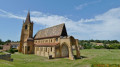
Park in the car park behind Melay Church.

(S/E) Walk past the church down to the junction with the D122.

(1) Turn left, then take the second right onto Rue des Dolards, heading towards the water sports centre.

(2) Cross the canal and turn left immediately afterwards to walk alongside it. Walk past the water sports centre, cross the tarmac road and continue straight ahead, following the canal for about 400 m.

(3) Look out for a small wooden staircase on the right. Take it, but be careful as it is in poor condition. Then turn right onto the path under the canal. Continue along the small stream and cross the footbridge on the left. Pass to the left of the old mill (right of way) and you’ll reach a junction.

(4) Take the track on the left to the cluster of houses, then continue left along the road to the D122. Turn left and walk carefully alongside it towards the canal.

(5) At the water sports centre, turn right onto the southern path along the canal.

(2) Turn right, join Rue des Dolards and continue to the D122. Turn left.

(1) Turn right and head for the car park behind the church (S/E).

Waypoints

  1. S/E : mi 0 - alt. 928 ft - Car park - Église Saint-Etienne (Melay)
  2. 1 : mi 0.07 - alt. 899 ft - D122
  3. 2 : mi 0.67 - alt. 863 ft - Junction of the circular loop - Canal de Roanne à Digoin
  4. 3 : mi 1.31 - alt. 856 ft - Stairs on the right
  5. 4 : mi 1.45 - alt. 843 ft - Towpath on the south side. Crossing the - Arcel (cours d'eau) - Affluent de la Loire
  6. 5 : mi 1.98 - alt. 860 ft - Water sports centre
  7. S/E : mi 2.99 - alt. 928 ft - Car park - Église Saint-Etienne (Melay)

Reviews and comments

5 / 5
Based on 1 review

Reliability of the description
5 / 5
Ease of following the route
5 / 5
Route interest
5 / 5
isabelle196542
isabelle196542

Overall rating : 5 / 5

Date of your route : Aug 06, 2023
Reliability of the description : ★★★★★ Very good
Ease of following the route : ★★★★★ Very good
Route interest : ★★★★★ Very good
Very busy route : No

Enjoy the little walk – we’ll do it again on a different route

Machine-translated

Other walks in the area

For more walks, use our search engine .

The GPS track and description are the property of this route's author. Please do not copy them without permission.