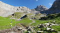
Lac Clou at the start of the Prioux route

A family hike with no technical difficulty in summer. It offers the chance to gain some height and take in views of the Pralognan Valley and the local glaciers. The Prioux car park is a pay-and-display facility; you can also use the council’s free shuttle buses to travel from Pralognan to Les Prioux.

Details

n°112098215
Creation:
Last update:
–
Last review:
–
  • Walking
    Activity: Walking
  • ↔
    Distance: 5.59 mi
  • ◔
    Average duration: 4h 05 
  • ▲
    Difficulty: Moderate

  • ⚐
    Back to start: Yes
  • ↗
    Ascent: + 1,732 ft
  • ↘
    Descent: - 1,732 ft

  • ▲
    Highest point: 7,224 ft
  • ▼
    Lowest point: 5,607 ft

Description of the walk

Park in the pay-and-display car park at Les Prioux.

(S/E) Cross the Doron de Bozel via the bridge, turn right onto the D124, and at thefirst junction leave it to take the signposted path on the left towards the Refuge de la Valette. Start climbing, and after a few hairpin bends you’ll reach a footbridge.

(1) Take the footbridge to the left to cross the Stream des Nants. Continue the climb until you reach the Chalet des Nants.

(2) Head towards the lake on the right, crossing several streams, until you reach a Y-junction.

(3) Carry on straight ahead, still skirting the Vanoise National Park, until you reach another junction.

(4) Stay on the path on the right and head for Lac Clou.

(5) Carry on straight ahead, still skirting the edge of the park, past the Chalet Clou. Cross the Ruisseau des Ferrandes. Walk gently downhill to a Y-junction.

(6) Take the path on the right, passing close to the Plan des Bôs chalet. Then, via a series of hairpin bends, reach the hamlet of Montaimont.

(7) Continue down the road until you reach the Route des Prioux.

(8) Turn right onto this road and continue to the Prioux car park (S/E).

Waypoints

  1. S/E : mi 0 - alt. 5,614 ft - Car park - lieu dit les Prioux
  2. 1 : mi 1.21 - alt. 6,722 ft - Footbridge
  3. 2 : mi 1.62 - alt. 7,195 ft - Chalet des Nants
  4. 3 : mi 1.87 - alt. 7,129 ft - Y-junction
  5. 4 : mi 2.29 - alt. 7,031 ft - Junction leading to the lake
  6. 5 : mi 2.6 - alt. 7,123 ft - Le Lac Clou
  7. 6 : mi 3.21 - alt. 6,867 ft - Junction towards Montaimont
  8. 7 : mi 3.98 - alt. 6,237 ft - Montaimont
  9. 8 : mi 4.9 - alt. 5,751 ft - Route des Prioux
  10. S/E : mi 5.59 - alt. 5,614 ft - Car park - lieu dit les Prioux

Notes

The initial ascent can be a little tricky in wet weather as it gets quite muddy.
(5) Lac Clou: there is usually some wildlife to be seen, such as insects and tadpoles.

Worth a visit

Other walks in the area

For more walks, use our search engine .

The GPS track and description are the property of this route's author. Please do not copy them without permission.