From Mijoux, take the D991 towards Chézery-Florens and park in Lélex 900 metres away in the car park opposite the cable car and the Tourist Office.
(S/E) With your back to the tourist office, turn left onto Rue des Monts Jura towards La Vielle Chapelle. You will come to a first crossroads.
(1) Continue straight ahead. Continue straight ahead again at the second junction at Les Chapelons and you will come to a Y-junction. Turn right onto Route du Frenet and continue to Pont de la Fruitière.
(2) At the bridge, continue left on the GR® and the road. Continue straight ahead until the road turns left and a track continues opposite. Stay on this track. From here, keep left until you reach Pont de Niaizet, passing close to a peat bog.
(3) Immediately after the bridge, keep left and climb towards Plat des Menues, passing to the right near an old customs office. Continue straight ahead on the road to Plat de Menues.
(4) Take the first path on the left, known as Sentier des Trente-Deux Contours. This will take you to Thoiry-Derrière.
(5) Keep left towards Reculet. Continue climbing until you reach the crossroads on a ridge.
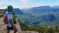
(6) Take the second path on the right towards the Reculet cross (erected in 1892).
(7) Enjoy the view at the summit and descend to the previous crossroads via the same route.
(6) Continue straight ahead on the GR® towards Crêt de la Neige. Ignore two paths on the right to find a third crossroads.
(8) Stay on the ridge until you reach Crêt de la Neige.
(9) It is considered the highest point of the Jura Mountains at 1,720 metres. At the crossroads at the summit, continue straight ahead towards Grand Crêt. Keep going until you reach the crossroads at Sous le Crêt.
(10) Go through the turnstile and descend via the GR® towards Les Brillones d'en Haut. Keep left at each junction until you reach the building.
(11) Pass in front of the building, then continue straight ahead to the Refuge de la Loge.
(12) Just after the Refuge de la Loge, the trail descends into the woods and zigzags between the trees. It joins the Refuge du Ratou.
(13) At the chalet, take the path on the left that descends towards Lélex. Continue straight ahead at the first three crossroads. Turn right at the fourth and then cut across a track. Then take the two paths opposite, downhill. Stay on the same track, which becomes a path, downhill to the starting crossroads.
(1) Turn right and return to the starting point via the same route as on the way up. (S/E)