Le Capucin via the Chemin des Médecins

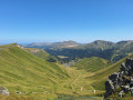
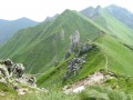
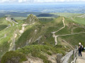
This walk, starting from the Capucins car park, takes you along the Chemin des Médecins, a route rich in biodiversity, before climbing to the summit. The descent is less steep. The walk follows well-maintained paths.

Details

n°108852152
Creation:
Last update:
Last review:
–
  • Walking
    Activity: Walking
  • ↔
    Distance: 3.17 mi
  • ◔
    Average duration: 2h 15 
  • ▲
    Difficulty: Easy

  • ⚐
    Back to start: Yes
  • ↗
    Ascent: + 889 ft
  • ↘
    Descent: - 886 ft

  • ▲
    Highest point: 4,754 ft
  • ▼
    Lowest point: 3,970 ft

Description of the walk

Start from the car park at the Salon des Capucins.

(S/E) Walk past the exhibition hall on your right and continue along the path opposite the hall.

(1) Turn right onto the Chemin des Médecins and carry on straight ahead.

(2) At the end, take the steep path on the right and begin the climb.

(3) At the top, turn right, then at the Y-junction, keep to the right.

(4) At the junction, head straight ahead to reach the summit.

(5) Turn back and return to the previous junction.

(4) Turn right, then, at the end, repeat the manoeuvre and continue along the road to the car park (S/E).

Waypoints

  1. S/E : mi 0 - alt. 4,104 ft - Car park at the - Salon du Capucin
  2. 1 : mi 0.15 - alt. 4,049 ft - Chemin des Médecins
  3. 2 : mi 1.22 - alt. 4,058 ft - 180° bend
  4. 3 : mi 1.71 - alt. 4,672 ft - Top of the climb
  5. 4 : mi 2.05 - alt. 4,682 ft - Crossroads
  6. 5 : mi 2.18 - alt. 4,751 ft - Le Capucin (1463 m)
  7. S/E : mi 3.17 - alt. 4,104 ft - Car park at the - Salon du Capucin

Notes

No water source

Worth a visit

Salon des Capucins

Other walks in the area

For more walks, use our search engine .

The GPS track and description are the property of this route's author. Please do not copy them without permission.