Country:

 City:
City:


(S) Set off from the Dédalys lodge towards the village of Laprugne.
(1) At the church, take the county road on the right which climbs to the hamlet known as “La Goutte”. In the middle of the hamlet, look out for the path leading up to the left into the forest. You’ll quickly gain altitude. At the three-way junction, take the path that climbs steeply up to an almost flat forest track coming in from the right. Follow it to the left for just a few metres, then turn right onto a barely marked path that climbs again and emerges from the woods fairly quickly.
(2) The path runs alongside a pond and climbs to the right. Open the yellow gate (make sure to close it properly behind you) to access the rest of the path, which turns left; then take the small road on the right that passes above the hamlet of Point du Jour and leads, on the right, to the hamlet of Roche.
(3) Continue along the road and, 100 metres after Roche, leave the road on the left to follow the path down to the D995. Keep left at the junction, then turn right and then left again until you reach the departmental road. Turn left, then take the next right.
(4) Follow the D422, which leads to the village of Lavoine. Pass the little church – which is unusual in that it belongs to the villagers rather than the local council – and arrive at the square where the superb water-and-ball clock stands; you can see it in action if you’re lucky enough to visit during the summer months. Continue due south, turning right, leaving the D422 as you exit the village and take the path on the right which leads to the lake.
(5) The path climbs to the left up to the road, which you should follow to the right before turning left to reach the hamlet of Pion, the former seat of the most famous of the peasant communities , which has inspired legends and songs. Overlooking the hamlet is a lovely spot for a picnic.
(6) On leaving the village, opposite the fountain, take the path on the right which crosses a pretty monolithic bridge and then follows a paved track, similar to those built by the Romans, leading to La Nélie.
(7) Take the forest track which climbs to the right to the day’s highest point at 1,004 metres: the Plan du Jat.
(8) Descend gently through the woods, straight ahead, for 3.6 km, to the Col de la Plantade.
(9) Cross the D122 to climb up to the hamlet of Philibin, where you should take the Route du Rez de Sol on the right. Leave this road at the third bend to take the path leading to the hamlet of Gratteloup.
(10) There, decide whether or not to do the 4 km round trip to the Pierre du Sang by turning right.
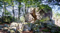
Otherwise, take the track on the left and then head straight on for a short 1.6 km round trip which takes you up to Rez de Sol with its beautiful views and its white and pink quartz boulders, where you can have fun trying to spot the legendary dragon with its mouth gaping towards the sky.
(11) Head back down the same path and take the last path on the right before reaching the junction. When you reach the D328, follow it due south to the hamlet of Tournaire, where you should leave the road and take the path running alongside it on the right as far as Dassaud.
(12) Walk through the whole hamlet, winding your way until you find, on the right and below you, a large forest track which, after a sharp bend to the right, heads due south again, descending through the woods. At the junction, keep to the right before continuing to the left as far as the Moulin du Ligonnet.
(13) At the road, turn right.
(14) Just after the Pont de l’Enfer, take the path on the left which runs alongside the River Credogne and then climbs to La Trappe, just below the small village of St-Victor-Montvianeix.
(15) Leave this on your right and take the D43 road, which climbs to the left towards the Ferme du Lac, 400 metres from the main road. There is no lake here, but three large lodges, each sleeping 15, housed in17th-century stone buildings, which were once the centre of a farming community, much like Les Pions ( E).
 Visorando Member
 Easy
Easy  Association / Club / Walk leader
 Moderate