La Penne-Mollans via Pierrelongue

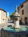
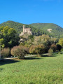
A walk that alternates between villages and woodland paths. Sometimes through the woods, sometimes through two magnificent villages in the Drôme, you’ll enjoy the varied scenery that unfolds before you. The River Ouvéze will be the guiding thread of this journey. The villages of Mollans and Pierrelongue are well worth a brief stop.

Details

n°70648922
Creation:
Last update:
Last review:
  • Walking
    Activity: Walking
  • ↔
    Distance: 6.82 mi
  • ◔
    Average duration: 4h 15 
  • ▲
    Difficulty: Moderate

  • ⚐
    Back to start: Yes
  • ↗
    Ascent: + 1,306 ft
  • ↘
    Descent: - 1,316 ft

  • ▲
    Highest point: 1,719 ft
  • ▼
    Lowest point: 892 ft

Photos

Description of the walk

 Leave the D5 by turning left towards Penne-sur-l’Ouvéze and park straight away in the large car park on your right.

(S/E) Head north-west towards Penne-sur-L’Ouvéze via the D525.

(1) Leave the road and take the path on your left (marked in yellow) leading up through the woodland at the edge of the meadow.

(2) At the Fork in the road, continue to the right, staying on the PR®-marked path, until you reach the D5.

(3) Turn right onto it and follow it towards Pierrelongue, walking along the wide grassy verge.

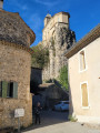
(4) Cross the road carefully, enter the village and admire the magnificent church perched on the site of an old fort. Go round the village on the left, rejoin the departmental road at a cross and follow it to the left for about 400 m.

(5) Cross the departmental road againwith care and turn onto the wide path heading south-west.

(6) Take the path on the right, heading due north, and climb up through the forest. Follow this signposted path to the Hauts Lants crossroads.

(7) At the crossroads, take the path on the left and head down towards the Ravin de Pisse Rouille to reach the 330-metre mark and rejoin a forest track.

(8) Cross the main road carefully and enter the village of Mollans-sur-Ouvéze; walk through the village and cross the bridge over the Ouvéze.

(9) Turn three-quarters of the way round to the right, go round the few houses until you see the river on your left, then follow it to the right.

(10) Leave the tarmac road running alongside the river, head up to the right and take the wide path through the woodland. The narrow Canal de Bluyes will be on your left. Follow it.

(11) Turn right into a wooded area, rejoin the road, head down it and reach the Ouvéze.

(12) Take the new, wide, refurbished track on your right and continue due east. Reach the magnificent brand-new footbridge and go through the old railway tunnel. Carry on straight ahead and cross the tunnel road.

(13) Turn left into the cul-de-sac, cross the Route de Buis (D5) again with care and head for the car park (S/E). 

Waypoints

  1. S/E : mi 0 - alt. 1,033 ft - Car park - Ouvèze (rivière)
  2. 1 : mi 0.16 - alt. 1,063 ft - Start of the path on the left
  3. 2 : mi 0.57 - alt. 1,211 ft - Fork in the road
  4. 3 : mi 0.74 - alt. 1,037 ft - Route de Buis, D5
  5. 4 : mi 1.08 - alt. 994 ft - Towards Pierrelongue
  6. 5 : mi 1.54 - alt. 1,024 ft - Climb back up through the woodland
  7. 6 : mi 1.78 - alt. 1,198 ft - Junction heading due north
  8. 7 : mi 2.65 - alt. 1,581 ft - Hauts Lants crossroads
  9. 8 : mi 3.3 - alt. 988 ft - Crossing the D5 again
  10. 9 : mi 3.61 - alt. 899 ft - Turn right at a 270° junction
  11. 10 : mi 3.71 - alt. 892 ft - towards the forest track
  12. 11 : mi 4.5 - alt. 942 ft - Junction
  13. 12 : mi 5.91 - alt. 971 ft - Newly renovated road
  14. 13 : mi 6.71 - alt. 1,027 ft - Junction
  15. S/E : mi 6.82 - alt. 1,033 ft - Car park - Ouvèze (rivière)

Worth a visit

Always be cautious and plan ahead when you're outdoors. Visorando and the author of this route cannot be held responsible for any accidents occurring on this route.

The GR® and PR® markings are the intellectual property of the Fédération Française de Randonnée Pédestre.

Reviews and comments

4.7 / 5
Based on 2 reviews

Reliability of the description
4.5 / 5
Ease of following the route
4.5 / 5
Route interest
5 / 5
Jacky Anx
Jacky Anx

Thank you for your positive feedback

Machine-translated

Francine84
Francine84

Overall rating : 5 / 5

Date of your route : Oct 15, 2026
Reliability of the description : ★★★★★ Very good
Ease of following the route : ★★★★★ Very good
Route interest : ★★★★★ Very good
Very busy route : No

A very pleasant, varied walk offering beautiful views. The sections along the road are soon forgotten. Mollans-sur-Ouvèze, a magnificent village, is well worth a more in-depth visit. It’s worth noting that the water from the fountains is the same water that supplies the village’s homes with drinking water. It’s excellent spring water. Don’t hesitate to fill up your water bottles. As for the Pierrelongue chapel, it stands out as a landmark in the landscape. Superb!
Thank you for sharing this.

Machine-translated

wilfrid80
wilfrid80

Overall rating : 4.3 / 5

Date of your route : Sep 09, 2025
Reliability of the description : ★★★★☆ Good
Ease of following the route : ★★★★☆ Good
Route interest : ★★★★★ Very good
Very busy route : No

A beautiful hike. It starts on a small, steep path, but it quickly levels out. You walk through the woods without difficulty despite the slope. There are many signs marking the route, but also other hikes, so the GPS track is very useful. You then walk along the busy road, but the verges are wide and easy to walk on. The crossing of Pierrelongue is pretty. After a few hundred metres back on the road, you come to a fairly steep track which then becomes a small path through the woods, followed by a fairly steep and rocky descent before crossing the busy main road again in a rather dangerous spot due to poor visibility. Then you cross Mollans, a very pretty village where the GPS is very useful. There is a nice picnic table at the exit, then another beautiful track that becomes a small shaded path on almost flat terrain. Next, you pass through the new greenway, its footbridge and tunnel to liven up the more monotonous end of the route.
A very pleasant hike, mostly shaded and not particularly difficult except for the elevation gain, which allows you to discover two beautiful picturesque villages.
Thanks to the author

Machine-translated

Other walks in the area

For more walks, use our search engine .

The GPS track and description are the property of this route's author. Please do not copy them without permission.