The capital of flax cultivation and its hamlets

A walk starting from Doudeville to explore the hamlets of the Caux region and their treasures: manor houses, a château, stately homes… The village of Doudeville is brimming with beautiful historic houses. The route alternates between tarmac roads, lowland paths and a section along an ancient Roman road.

Details

n°1319165
Creation:
Last update:
Last review:
  • Walking
    Activity: Walking
  • ↔
    Distance: 11.69 mi
  • ◔
    Average duration: 5h 45 
  • ▲
    Difficulty: Moderate

  • ⚐
    Back to start: Yes
  • ↗
    Ascent: + 397 ft
  • ↘
    Descent: - 394 ft

  • ▲
    Highest point: 509 ft
  • ▼
    Lowest point: 364 ft
  • ⚐ Country: France
  • ⚐ City: Doudeville (76560)
  • ⚑
    Start/End: N 49.724374° / E 0.781457°
  • ❏
    IGN map(s): Ref. 1909OT, 1910SB
  • Hour-by-hour weather

Photos

Description of the walk

Car park on the right, on the hill, heading towards Saint-Valéry-en-Caux. Departmental Road 20, Rue du Colonel Person.

(S/E) With your back to the car park, turn right and walk alongside the cemetery. At the roundabout, turn left onto Rue Bad Nenndorf. Immediately afterwards, take the path on the right (marked in green). Continue straight on, some distance from the D20.

(1) Turn right onto Rue de la Mare au Loup (hamlet of Vautuit). Cross the D20 and, opposite, slightly to the left, take the road towards the hamlet of Fresnay.

(2) At the end, at the Y-junction, turn right. At the stop sign, at the T-junction that follows, turn left.

(3) Take thefirst track on the right. At the end of the track, follow the road to the right and pass through the hamlet of Colmont.

(4) On leaving the hamlet, at a Fork in the road, turn right towards Galleville. At the next junction (marker 138), carry straight on. At the T-junction, follow the road to the right for about 150 metres.

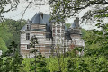
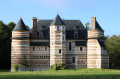
(5) Take thefirst left, Rue du Château. Pass between the château on your right and its outbuildings on your left (dovecote, lodges, etc.). Carry on straight ahead towards Doudeville.

(6) At the Stop sign (on the right is a manor house housing the “Le bateau de Brotonne” association), turn slightly left onto the D37 (Rue Gustave Halu). At the end, turn left onto Rue Auguste Cavé (D149; watch out for traffic).
Leave the village, staying on the D149.

(7) Take thefirst right, Rue du Chêne Hérondel, towards the hamlet of Seltot.

(8) Once you reach the hamlet, turn right twice. Join the D67 and follow it to the right.

(9) At the junction, turn left onto Chemin Harangue (initially tarmac, then a dirt track).

(10) At the end of the track, first turn left then right to follow Rue du Champ de Courses. Go straight on, cross the D20 (take care) and continue straight ahead onto Rue du Bois Marie.

(11) At the junction, turn left (due south) onto Rue de la Folie (towards Bosc Adam). This is an old Roman road, initially tarmac, then a dirt track. Cross the old Rouen–Saint-Valéry-en-Caux railway line and continue to the road.

(12) Then turn right. Next, take a left-hand bend followed by a right-hand bend. At the junction, first turn right then left and follow the Route du Bois d’Aumare.

(13) Cross the D37 and take the forest track directly opposite. Walk through the Bois d’Aumare.

(14) Cross a small road and continue straight ahead along the dirt track leading to the hamlet of Pichemont, opposite the manor house of the same name.

(15) Cross the junction and, facing the manor house, turn left onto Rue du Manoir. At the next junction, turn right onto Route de Pichemont. Follow this road, ignoring Rue du Petit Pont which branches off to the right, and walk alongside the railway line.

(16) At the junction with the D149 (former Doudeville station), turn right and follow Rue de la Gare. Carry on straight ahead until you reach the traffic lights.

(17) Turn left and you’ll soon reach the starting car park (S/E).

Waypoints

  1. S/E : mi 0 - alt. 453 ft - Car park, Rue du Colonel Person
  2. 1 : mi 1.13 - alt. 456 ft - Rue de la Mare au Loup
  3. 2 : mi 2.01 - alt. 433 ft - Fresnay Manor – Access
  4. 3 : mi 2.29 - alt. 394 ft - Start of the trail
  5. 4 : mi 3.05 - alt. 420 ft - Colmont – Fork in the road
  6. 5 : mi 3.75 - alt. 486 ft - Galleville
  7. 6 : mi 4.43 - alt. 413 ft - Rue Gustave Halu
  8. 7 : mi 5.19 - alt. 499 ft - Rue du Chêne Hérondel
  9. 8 : mi 5.79 - alt. 489 ft - Seltot
  10. 9 : mi 6.28 - alt. 436 ft - Chemin Harangue
  11. 10 : mi 6.95 - alt. 502 ft - Bosc Mare
  12. 11 : mi 7.53 - alt. 479 ft - Rue de la Folie
  13. 12 : mi 8.53 - alt. 509 ft - Route de Bosc Adam
  14. 13 : mi 9.25 - alt. 430 ft - Crossing the D37
  15. 14 : mi 9.92 - alt. 420 ft - Crossroads
  16. 15 : mi 10.39 - alt. 390 ft - D110 – Rue du Manoir
  17. 16 : mi 11.05 - alt. 390 ft - Route de la Gare
  18. 17 : mi 11.47 - alt. 387 ft - Crossroads
  19. S/E : mi 11.69 - alt. 453 ft - Car park, Rue du Colonel Person

Notes

This route, marked in green and signposted as a walking trail, presents no particular difficulty. It was originally proposed by the Caux Maritime Plateau Tourist Office and has been slightly revised by me.

Worth a visit

Galleville Castle, the Fresnay Manor House, the Pichemont Manor House.
Do take the time to visit Doudeville, home to many beautiful mansions.

Reviews and comments

4.7 / 5
Based on 1 review

Reliability of the description
5 / 5
Ease of following the route
4 / 5
Route interest
5 / 5
benoitrando
benoitrando
• Edited:

This has been amended today; thank you for bringing it to our attention

Machine-translated

Amélie710
Amélie710

Hello,
I’m getting in touch as I’ve just realised that your Visiorando route uses a section of private land, namely the path leading to the manor house. Would it be possible to change this?
Kind regards,

Machine-translated

benoitrando
benoitrando

Hello Brutard, could you tell me, roughly, where there’s a problem with the path so that I can make a change if possible?
Thanks in advance
Kind regards
benrando

Machine-translated

brutard
brutard

Overall rating : 4.7 / 5

Date of your route : Nov 27, 2019
Reliability of the description : ★★★★★ Very good
Ease of following the route : ★★★★☆ Good
Route interest : ★★★★★ Very good

There’s a stretch where the path disappears, having been ploughed up by the farmer; there’s a faint trail across the field – you just have to trust it, and then everything will be fine

Machine-translated

Other walks in the area

For more walks, use our search engine .

The GPS track and description are the property of this route's author. Please do not copy them without permission.