Country:
 City:


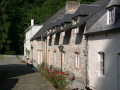
Park at the Notre Dame du Vivier Abbey car park on the N992, 1 km from the N959 running alongside the Meuse. Access by public transport: the Marche-les-Dames SNCB station is 1.2 km away.
(S/E) Leave the Abbey via the path at the foot of the hillside between the woods and the boundary wall.
(1) About a hundred metres further on, take the steep path leading uphill to the left; follow it straight on, ignoring the signposts.
(2) After 200 metres, carefully follow the path to the right which runs along the top of the valley (the military have installed a ‘monkey bridge’ which you can reach by continuing straight on for a few tens of metres – DO NOT USE IT UNDER ANY CIRCUMSTANCES).
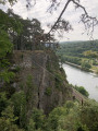
(3) The path continues along the edge of the cliff and leads to a first viewpoint overlooking the Meuse and Brumagne Castle. From the viewpoint, walk 200 metres back up towards the signposted path, which you follow to the left
(4) About a hundred metres further on, you can reach a second viewpoint; then turn back to rejoin the signposted path
(5) The signposted path continues along the cliffs for approximately 1.2 km. At the hairpin bend, carry straight on and follow a descending path which rejoins the signposted route; follow this to the left for 150 metres
(6) 150 metres further on, take the steep path that climbs the slope to the right, joining a track which you follow to the left
(7) After 250 metres, take the path on the left which descends towards the Meuse
(8) It leads onto Rue du Mont, which you follow to the right. After the last houses, the street becomes a track and continues as a path that goes round the Beez quarry
(9) After approximately 1.5 km, turn right at a right angle (do not follow the path straight ahead, which joins the N80)
(10) After 1 km, turn left towards the N80
(11) When you reach the N80 (car park), take the path that starts diagonally to the right. It runs alongside a woodland, then turns right and enters a woodland
(12) At the first junction, turn left. The path runs along the edge of the woodland for 2.5 km. I
(13) It comes out onto Rue Notre Dame du Vivier. Cross the road and take the path on the left which runs alongside the sports ground and rejoins the road. At the sewage treatment works, take a path on the left.
(14) After 100 metres, it crosses the Gelbressée stream and climbs towards the ridge. It joins a track; follow it to the right.
(15) After 100m, take the path that descends to the left and rejoins Rue Notre Dame du Vivier.
(16) Walk up the street to the right and cross over; 30 metres further on, turn left into the main entrance avenue to the abbey to return to the starting point.
 Visorando Member

 Tourist office
 Easy