Dolce Via starting from the Chalets du Boucillon

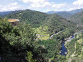
This walk follows a lovely path – part of the Dolce Via – along the River Eyrieux.

Details

26976372
Creation:
Last update:
Last review:
  • Walking
    Activity: Walking
  • ↔
    Distance: 5.72 mi
  • ◔
    Average duration: 3h 15 
  • ▲
    Difficulty: Easy

  • ⚐
    Back to start: Yes
  • ↗
    Ascent: + 712 ft
  • ↘
    Descent: - 732 ft

  • ▲
    Highest point: 1,247 ft
  • ▼
    Lowest point: 502 ft

Description of the walk

Start from the Chalets du Boucillon. For more accessible parking, see the practical information.

(S/E) Follow the road uphill.

(1) After about 900 m, at a reservoir, take the signposted GR® path (red and white) on the right. Stay on the GR® path, ignoring any side paths, until you reach a road.

(2) Continue along the GR®: follow the road to the right, then at the junction go a few metres to the left before turning right, cross the hamlet and come out onto a departmental road. Cross it, taking care, and follow it to the right for 50 m, then take the road to the left, and left again at the junction.

(3) At the next junction, carry on straight ahead, making a round trip, to see the view from the Pont de la Pimpie.

(4) Retrace your steps.

(3) Keep to the road on the left: this is the Dolce Via (follow it as far as Les Salins).

(5) Pass the entrance to the campsite and continue along the Dolce Via. Join a road at Les Ollières-sur-Eyrieux and follow it to the left.

(6) Take the second street on the right and stay on the Dolce Via at the junction.

(7) Pass a campsite on your left and reach Les Salins. ⚠️ Just before Les Salins, do not take the shortcut through the hamlet on your right, as it is private property.

(8) After the bridge, take the Montée des Salins on the right at the hairpin bend. ⚠️ Do not go through the hamlet, as the paths there are private.

(9) Continue along the main road for 50 metres before taking the first road on the left. At the junction, take the sharp left-hand bend onto the Route du Boucillon to return to the Chalets du Boucillon (S/E).

Waypoints

  1. S/E : mi 0 - alt. 1,056 ft - Les Chalets du Boucillon
  2. 1 : mi 0.55 - alt. 1,247 ft - Reservoir
  3. 2 : mi 1.26 - alt. 696 ft - Junction
  4. 3 : mi 1.57 - alt. 571 ft - Round trip to the bridge
  5. 4 : mi 1.65 - alt. 502 ft - Pont de la Pimpie - Eyrieux (rivière) à finaliser
  6. 5 : mi 2.38 - alt. 620 ft - Junction, Le Plot
  7. 6 : mi 2.93 - alt. 646 ft - Crossroads
  8. 7 : mi 3.45 - alt. 666 ft - Campsite
  9. 8 : mi 4.42 - alt. 646 ft - Les Salins
  10. 9 : mi 5.17 - alt. 853 ft - Route de Saint-Michel de Chabrianoux
  11. S/E : mi 5.72 - alt. 1,056 ft - Les Chalets du Boucillon

Notes

If you are not staying at the Chalets du Boucillon, you can start the walk from the old Ollières-sur-Eyrieux railway station; there is plenty of parking there

Always be cautious and plan ahead when you're outdoors. Visorando and the author of this route cannot be held responsible for any accidents occurring on this route.

The GR® and PR® markings are the intellectual property of the Fédération Française de Randonnée Pédestre.

Reviews and comments

4.1 / 5
Based on 4 reviews

Reliability of the description
4 / 5
Ease of following the route
4.3 / 5
Route interest
4 / 5
User 15191628

Overall rating : 4.3 / 5

Date of your route : Apr 06, 2026
Reliability of the description : ★★★★☆ Good
Ease of following the route : ★★★★★ Very good
Route interest : ★★★★☆ Good
Very busy route : No

No worries on this walk.

Machine-translated

catche
catche

Overall rating : 4 / 5

Date of your route : Aug 31, 2025
Reliability of the description : ★★★★☆ Good
Ease of following the route : ★★★★☆ Good
Route interest : ★★★★☆ Good
Very busy route : Yes

Nice route... not difficult...
At point 1, the path is private. Continue for a few metres and a small path leads down into the forest... You will find the route again a little further down.

Machine-translated

Lionel11410
Lionel11410

Overall rating : 4 / 5

Date of your route : Aug 06, 2025
Reliability of the description : ★★★★☆ Good
Ease of following the route : ★★★★☆ Good
Route interest : ★★★★☆ Good
Very busy route : No

A pleasant route that takes you through a wooded area before joining the Dolce Via and offering beautiful views of the Eyrieux Valley.

Machine-translated

randofamille07
randofamille07

Overall rating : 4 / 5

Date of your route : Oct 21, 2024
Reliability of the description : ★★★★☆ Good
Ease of following the route : ★★★★☆ Good
Route interest : ★★★★☆ Good
Very busy route : No

A real treat for any railway enthusiast. The others were very generous in sharing their stories.

Machine-translated

Other walks in the area

For more walks, use our search engine .

The GPS track and description are the property of this route's author. Please do not copy them without permission.