Country:
 City:
City:





Starting point and access: Verneuil-l’Étang station .
- Transilien – Line P, on the section between Paris-Est and Provins.
Take the only exit, platform 1, for trains travelling from Paris to Provins (if arriving from the opposite direction, platform 2; take the footbridge).
Blue + Red and White signposting
(S) On leaving the station, turn right into Rue de la Gare. Pass Rue Pasteur on your left, then Rue de La Fontaine on your right. At the stop sign, continue straight on along the D99 towards Courpalay. At the T-junction, turn left into Rue Arthur Chaussy.
No signposting
(1) Take the first right onto Rue Jean Jaurès. You’ll cross Rue Émile Zola on your right. Pass between the war memorial on your left and the church on your right, and you’ll come to a roundabout.
(2) Go round the roundabout on the left and take the first exit, still on Rue Jean Jaurès, going against the one-way traffic.
Blue + Red and White markings
At the end, take the second track on the right – a dirt track – and pass a small EDF substation on your right. Walk along the edge of the fields on your left and the woodland on your right, ignoring all the turnings on the right.
(3) At the junction (with the Grange Saint-Père farm opposite), turn right onto a farm track and walk alongside a fenced wood on your left.
Blue signposting (rare)
At the next junction, continue straight on along the edge of the woodland. Cross a small bridge over the embankment of an old railway line and continue straight on between the fields.
(4) Cross the D32 carefully and continue straight ahead on a path along the edge of the woodland. At the junction, turn right. Walk along the left-hand side of a fallow field, then a woodland. At the end, go round a pile of rubble on the right and emerge onto the D32e4 at the entrance to Argentières.
Unmarked
(5) Cross the road carefully, continue along the path opposite and pass a few houses on your left. Then walk between fields on your left and the woodland of the Château de Beauvoir park on your right. You’ll come to a small road at the foot of a telecommunications mast.
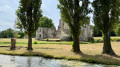
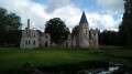
(6) Follow the road to the right. Then enter Beauvoir via Rue de Forbleu and walk alongside the wall of the château grounds. At the T-junction, turn right onto a wider street, using the pavement on the right-hand side, and you’ll soon reach the château’s entrance gate.
(7) Continue straight on along the main road for a further 150 m or so.
(8) Then turn left into a small, shaded square and walk past the church, the former village school and the town hall. Cross Rue Bouchée on the right-hand side and continue straight ahead.
(9) At the T-junction (with a beautiful, long house opposite), turn right onto Rue de l’Étang. Then take the first left. Very soon, at number 12, the tarmac gives way to a track. Turn left onto this track and join Rue de la Borde (with the old village washhouse opposite).
(10) Follow this small road to the right, passing a small sewage treatment plant.
(11) At the Stop sign, carefully cross a main road and continue straight ahead onto a farm track. Further on, the track gives way to a very narrow road.
(12) You’ll emerge onto a small road (with a farmhouse opposite) and follow it to the left. Immediately ignore a turn-off to the right towards Courgousson. At the ‘give way’ sign, at the entrance to Aubepierre, carefully cross the D32 and follow it to the right. Soon after, ignore a street on the left and pass by the foot of the church.
(13) At the Stop sign, carry straight on along the D32e3 towards Ozouer-le-Repos.
Blue signposts (rare)
At the junction immediately ahead, continue straight on along the D32e3.
(14) Take the first right, at the corner of a large farmhouse. Walk past some trees and a pond on your left. At the corner of a shed, turn left onto a farm track.
(15) At the first junction, turn right (there are no arrows or markers here, as there is nothing to attach them to). Pass at the foot of a high-voltage pylon. Further on, cross a stream (shaded crossing), continue along the track and ignore a turn-off to the left.
(16) Take the bridge over the railway line. Then walk through a housing estate, ignoring the side streets and dead ends.
(17) At the Stop sign, turn right. At the traffic lights you’ll soon come to, carry on straight ahead along the D227 towards Coulommiers. Just before the level crossing, turn left and cross the road with care. You’ll immediately find Mormant station on your right (E).
To get back home:
- Transilien – Line P, towards Paris-Est (direct access) or Provins (use the underpass).
 Visorando Member
 Difficult
 Very difficult