Country:

 City:
City:


Starting point and access: Fontainebleau-Forêt stop.
- Transilien – Line R, on the section between Paris-Lyon and Montargis (the stop is situated between Bois-le-Roi and Fontainebleau-Avon stations).
N.B. Services to the forest stop are limited (see the ‘Practical Information’ section for further details):
~ There are no services to the stop on weekdays.
~ It is only served on journeys from Paris to Montargis. Passengers alight at the front of the train, on the gravel-covered area which serves as a platform.
No signage
(S) With your back to the railway line, turn right. Walk alongside the railway line on your right-hand side for about 300 metres. When you reach a sign on the right-hand side, turn left onto the Route de la Coimelle.
(1) At the junction, turn right onto Route de l’Agaric. At the next junction, continue straight on for just under 100 metres.
Blue signposts
(2) At the junction, turn left onto a path (take care to spot this turn-off). At the next junction, go straight on and follow the marked path as it winds its way.
(3) At the junction of paths no. 13 and no. 15, go straight on (north). Cross Route Farewell and, at the junction immediately after, continue straight on.
(4) You’ll come out onto the D137 at the entrance/exit to Samois-sur-Seine; first turn left then right to take the Montée de Thérouanne towards Quai Franklin Roosevelt. Walk downhill, keeping to the left-hand side of a wall.
No signposting
Then go down a flight of steps to reach the banks of the Seine.
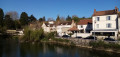
(5) Turn left and walk along the river on your right (there are some lovely houses along the quay). At a fork in the road, turn right and note a square on your left featuring a statue of Django Reinhardt. Take a footbridge over a branch of the Seine and cross the Île du Berceau. At the end, take another footbridge and continue along the quay.
(6) At the fork in the road, turn right onto the towpath, a tarmac dead-end track (with moored barges). Further on, the tarmac gives way to a stony path, then to a shaded dirt track and finally to a footpath. Cross an open area (benches; car park some distance away on the left) and continue along the Seine.
Signposting: Red and White + Green and White + Yellow
Ignore the path coming from the left and carry on along the shaded path beside the Seine.
No markings
(7) At a Fork in the road (sign for cyclists), turn left onto Route de la Pépinière. At the junction (marker 47), turn left onto Route du Chêne Tordu. Carry straight on, due east, and cross Route du Putois and then Route du Bois la Dame in turn. This will take you to Carrefour du Planteur.
(8) Cross a compacted track and continue roughly straight ahead along Route du Chêne Tordu. At the next junction, take the second left, still on Route du Chêne Tordu.
(9) At the junction, turn right onto Route de Magenta. At the end, go through a forest gate, cross the D116 with care, go through another forest gate and continue along the track. Take the first left onto Route Marrier. At the first junction, go straight on and follow a pond on your left. You’ll come to a second junction with a pond on your right (plots nos. 331 and 332).
(10) Then turn right onto Route de l’Épageul (not signposted here). At the next two junctions, go straight on. Then veer right along the track and you’ll reach Carrefour Napoléon.
(11) Continue straight on along Route du Chasseur. You will soon cross Route de Sermaise; carry on straight ahead until the next junction.
(12) Then take the second left, Route du Lieutenant (signposted further on), between plots no. 317 and no. 309. At the first junction, carry on straight ahead.
(13) At the second junction (parcels nos. 317 and 310), turn left onto a footpath (Route de la Battue on the map). At the crossroads, take the first right, between parcels nos. 335 and 317. At the first junction, go straight on.
Green and white markings
(14) At the second junction, turn left onto a path marked by old sandstone boundary stones (which once marked the boundaries of the royal estate of Fontainebleau).
(15) At the next junction, turn right onto Rue du Cormier (tarmac, signposted further on). Ignore a narrow lane on the left and carry straight on. At the end, turn left and take the first right, Rue du Mossu. At the end, turn right.
(16) Shortly after No. 13, turn left onto a path that winds its way between two walls, then between garden fences. At a three-way junction, veer left. At the T-junction that follows, turn left again. Ignore a path branching off to the right and pass between a wall on the left and a wash house on the right.
(17) At the corner by the wash house, turn right and walk alongside a stream on your right. Then turn right along the path, cross the stream and walk alongside a fence on your left. At the corner of the fence, turn left. Further on, cross the stream again and ignore another path on the right. Turn left along the path to come out onto a street running alongside the cemetery.
(18) First turn left then right to take a cul-de-sac and walk along the cemetery wall on your right. At the corner of the wall, turn right then left, passing a car park on your right.
Green and white + yellow markings
(19) At the end of the tarmac, go through a forest gate, enter a wooded park and immediately ignore a turning on the right. Walk with the sports facilities of a secondary school on your right. Keep going straight ahead and ignore all turnings on the left.
(20) At a junction by the roadside, turn sharply left. Enter the town hall grounds and carry on straight ahead. Pass the town hall on your right, cross a road and turn left onto a path. Walk through a small wood, following the signposted path. At the end, turn right, join an avenue and follow it to the right for about fifty metres.
(21) At the junction, turn left and go under the railway bridge. On the other side, turn right and you’ll soon reach Bois-le-Roi station (E).
To return home:
- Transilien – Line R, towards Melun and Paris-Lyon (immediate access) or towards Montargis or Montereau (take the underpass; it is also possible (21) to continue straight ahead to quickly find the access to the platform on the left).


 Visorando Member
 Difficult

 Easy
Easy