Country:
 City:


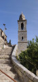
Head to Cargiaca via the RD69. The village consists of just one main street, with no car park. You can park directly on the road by the small church or near the small square by the nearby war memorial.
(S/E) Stay on the road (D69), heading north towards the outskirts of Cargiaca, and, at a bend to the right, reach the junction with a slightly uphill cobbled path opposite.
(1) Leave the D69 and take this slightly uphill cobbled track (signposted for Zérubia) to the fountain a few metres further on.
(2) Just before the fountain, turn sharply left and take the small path that climbs above the fountain. Yellow markings indicate the route to follow throughout the walk. At the village’s water intake station, go through the gate – making sure to close it behind you – then continue along the path which climbs steeply. Carry on through the holm oak woodland until you reach a high point. The path then becomes more pleasant as it follows the contour line and reaches a fork in the road.
(3) Take the track on the left, which climbs slightly, ignoring the path on the right that leads downhill. Continue, keeping a close eye on the yellow markings. As you approach the bridge over the river, the track overlooks the road before joining a wide track below.
(4) Leave the narrow path by heading downhill and going round a ruined house on the left to join a wide, flat track. Turn sharply right and join the D69. Turn left, cross the bridge over the Scopamène, and you’ll come to a right-hand bend just after the bridge.
(5) Leave the D69 and take the path opposite, which is clearly signposted by a directional post, towards Zérubia. Begin the climb, first in open country and then through woodland.
(6) Continue up towards the village, following the yellow markings until, at the end of the woodland, you reach a fairly steep, open slope (chestnut trees) which leads onto a street in Zérubia.
(7) Take the street on the left to begin a short circular route. Atthe first junction, turn right onto the path leading to the D120. Follow it until you reach a right-hand bend.
(8) Keep left onto the small, uphill street leading to the church.
(9) From the church square, enjoy a lovely view towards the Coscione plateau and Aullène to the north. Return by walking down the small street to the junction with the D120.
(8) Turn left, then right to complete the circular loop.
(7) Turn left to join the yellow markings indicating the start of the “paese à paese” path. Go over the low wall, then begin the descent into the woodland. Follow the yellow markings carefully and take the same route as on the way out but in the opposite direction, until you reach Cargiaca and its main street near the church (S/E).

 Visorando Member

 Local authority
 Easy