Country:

 City:
City:


Note: this walk follows the yellow-marked Sentier Littoral (PR®) coastal path, with various signposts. However, it would be best to save the route on your mobile phone, as this would be easier. There are many sections and paths that are not obvious if you follow the description alone.
The walk starts at the car park at Cap Cerbère, on Route d’Espagne, just past the Cerbère cemetery when coming from Banyuls-sur-Mer.
Leave your car at the Phare de Béar car park for the return journey, or use the LiO public transport service – a €2 bus from Port-Vendres – or join the D914 from (21) via the Chemin du Forat towards Paulilles.
(S) From the car park, head down the Route d’Espagne (D914), entering Cerbère, where there is a lovely view of the bay. Pass the Jean Jaurès Primary School, then the Cerbère Town Hall.
(1) Just before the sharp right-hand bend, go up the steps on the left into Rue de Vigny. Continue straight ahead into Rue Pasteur, then onto Avenue de la Côte Vermeille, and further on rejoin the D914.
(2) Turn left onto the Route de Banyuls and follow it for about 150 metres.
(3) Head down to the right onto a path that runs along the coast at Cap Canadel. Follow this route carefully without getting too close to the edge.
(4) Continue straight on along this route, passing through Anse de Terrimbo.
(5) Walk past the holiday village and Cerbère municipal campsite to reach Cap de Peyrefite.
(6) Follow the path straight on behind the campsite until you reach a crossroads.
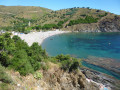
(7) Turn right, heading towards the coast in the direction of Peyrefite Beach.
(8) Leave the road, turn right onto the path and walk along the beach. Go round the beach to the right towards Punta d’en Cames. Continue along the path, moving away from the coast.
(9) The path winds to the right in a spiral. Pass a well, then a car park with picnic tables. Before the Route de Cerbère D914, turn right towards Les Esperades and rejoin a road.
(10) Continue straight on along this road, towards Taillelauque Beach.
(11) Carry on to the left, moving away from the coast.
(12) Turn left towards Tallalauca, then take the second right.
(13) Carry on straight along the track, cross the Rec de Tallalauca, pass a sewage treatment plant on your right and you’ll come out onto a road.
(14) Carry on straight along this road for about 500 m.
(15) At the right-hand bend, take the left-hand road to rejoin the D917. (Do not take the path on the right which goes down the steps.) Continue carefully along the road until you reach the roundabout. Turn left onto Avenue de la Côte Vermeille (D914).
(16) At the bend, leave this road and go round the back of the Banyuls-sur-Mer Oceanographic Observatory. Pass the Biodiversarium Aquarium as you rejoin Avenue Pierre Fabre (or Quai Georges Petit). Walk past Place de la Méditerranée. Cross the Pont de la Baillaury, passing the Banyuls Post Office and the Maison France Services. Walk along the beach and the Port of Banyuls.
(17) At the roundabout, go down the steps on the right, then continue along Allée des Elmes. Keep right at the road, walk alongside the Résidence les Elmes until you reach the sharp left-hand bend.
(18) Turn right onto a road at Cap des Elmes Punta. Follow the coastline past Cap Castell de Velló until you reach a crossroads.
(19) Turn right, continuing along the coast as you go, until you reach Cap d’Ullastrell.
(20) Turn left towards the small coves, Plage del Forat.
(21) Then Bernardi Beach and Balanti Beach. Stay firmly on the route.
(22) Turn right towards Anse de Santa Catarina, then the Béar Lighthouse, to return to the vehicles. (E)
You can return to (S) by LiO public transport, travelling to the Port-Vendres marina at Quai François Joly.
 Visorando Member
 Easy
Easy 
 Difficult