Country:

 City:
City:


Start at Malons-et-Elze. A small car park by the D155 on the outskirts of the hamlet when approaching from the north.
(S/E) Head south on the D155. Pass thefirst junction and reach a fork in the road. Leave the D155 and take the left-hand track; you’ll immediately come to a three-way junction. Take the path opposite (GRP®) for a steep climb that takes you past a telecoms mast before reaching a fork that’s not very visible.
(1) Leave the GRP® to your left. Turn right onto the wide drovers' road called Ancienne Draille du Languedoc; it is a wide drovers' road, sometimes a little overgrown, but easy to follow. Walk for over 2 km before reaching a track.
(2) Turn right onto it to reach a Fork in the road straight away; turn left. At the next Fork in the road, which is very close by, turn right into the woodland onto the ‘Ancienne Drovers' Road of Languedoc’ and reach a T-junction.
(3) Turn right onto the GRP® and you’ll very quickly reach a crossroads at the Croix de la Garde de Dieu. Turn left, then immediately right onto the wide track (GRP® de la Haute Vallée de la Cèze). Follow it due south on a gentle descent: a fairly easy ridge walk (no need to worry about heights!) leading to a fork in the road (Cham de Bonnevaux signpost, 918 m).
(4) Leave the GRP® and continue straight ahead, due south, towards the Col du Péras: yellow markings (difficult path) to reach the Col du Péras and the D320.
(5) Follow the road to the right (GRP®) for a few metres, then take the narrow path that drops sharply to the left to cut across the three hairpin bends of the departmental road: this section is quite challenging as it is steep and very stony.
(6) At thethird and final junction with the D320, continue along the path opposite. It turns immediately to the right and eventually joins a small road at the entrance to Les Bouchets.
(7) Follow it to the right, leave the GRP®, cross the hamlet and head left (west) along a good path (yellow markings) which eventually joins the D155A at the entrance to Salveplane.
(8) Follow it to the right and, 50 metres further on, take the path branching off to the left (yellow markings and a few houses on the left). After a sharp bend to the left, you’ll reach a wider track.
(9) Follow it to the right, cross a footbridge and reach a small road. Follow it to the right (follow the GRP® signposting for the Haute Vallée de la Cèze until you reach your destination) for about fifty metres, before turning left to pass through the hamlet of Gouder after a wide hairpin bend to the right. About a hundred metres past the last house, you’ll come to a path on the left.
(10) Take this path, first heading west then due north. Through the woodland, you’ll reach the D155.
(11) Follow it briefly to the right before taking the path on the left. Follow this path, still heading north through the woodland, until you reach a junction at a place called La Tranchée de Ponteils (hiking signpost).
(12) Take the road opposite, marked with the GRP® sign. At the Fork in the road, turn left, passing through the hamlet of La Lauze, then past a telecoms mast. After a series of three wide hairpin bends, you’ll come to a path on the right.
(13) Follow this path. At the crossroads, carry on straight ahead and head down to the Rivière de Bournaves. Cross via the footbridge and head back up to the “Chabottes” signpost.
(14) Carry on to the right, towards Malons, until you reach a Fork in the road. Keep right and head downhill to rejoin the River Bournaves: footbridge and a pretty gorge. Cross over and, after a section over rocky slabs, rejoin the path that climbs up to the hamlet of Bournavettes.
(15) Just before the first houses, don’t miss the path branching off to the left. Head uphill until you reach a Fork in the road.
(16) Carry on to the left (no signposting) and head downhill to cross a small stream. Then head back uphill to a Fork in the road marked ‘Bournaves’.
(17) Turn right to find a flight of steps. Take these (there’s a lovely farmhouse at the top) and carry on straight ahead up a steep climb (note: it gets hot here as the hamlet is very exposed). There are signposts, but you need to look carefully. A series of paths takes you through Bournaves; don’t miss its striking little bell tower. You’ll come to a small road.
(18) Follow it uphill to the right until you reach a hairpin bend. Just after this, don’t miss the path branching off to the left – a steep, very stony and rather uncomfortable climb – which cuts across a hairpin bend in the road before rejoining it. Continue to the left until the next hairpin bend.
(19) Leave the road and take the path opposite. Return to the D155 and follow it to the left to reach the car park (S/E).
 Visorando Member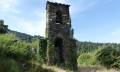
 Difficult
 Moderate
 Local authority