Country:
 City:




Access by car: coming from Bastia or Saint-Florent via the D81, reach the Col de Teghime then follow the D38. From there, drive down to the junction leading to the hamlets of the village of Poggio d’Oletta. Turn left onto Via Maria Ghjentile, then follow the road to Poggio until you reach the last hamlet. Park in the communal car park.
To preserve the natural character of this exceptional route, we have decided not to mark the route. There is no paint, barrier tape or even cairns. Simply follow the directions in this description.
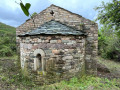
(S/E) From the “parcaghju cumunale” (in Corsican), head up towards the hamlet, which is visible ahead, until you reach the Chapel of the Holy Cross
(1) Turn right, skirting the back of the chapel, then right again. Follow the Stradunettu di San Antone road, which becomes a track a little further on.
(2) Continue to the right along Stradunettu di San Antone until, at the first high point after 1.7 km, you reach a crossroads of tracks.
(3) At the junction, continue to the right. The track then becomes a footpath. You’ll come to a fence with a field gate.
(4) Go through the gate, making sure to close it behind you. Continue for about 200 m along Stradunettu di San Antone until you reach another path/track junction.
(5) At the junction, turn left and head uphill along the track until you reach another junction
(6) At the junction, continue climbing to the left to reach the Sant’Antonio Pass
(7) At the pass, walk past the cross marking the spot and take the track heading north.
(8) Reach the highest point at Cime de Furtine.
(9) From Cime de Furtine, descend to the Col de la Coix de Menta. From there, continue for 1.5 km to the track/path junction at the foot of Monte a Torra
(10) At the foot of the mountain, leave the track and climb to the summit via a path on the left. Reach the summit at 852 m.
(11) From the summit, descend via the same route to the Col de Sant’Antonio
(7) At the pass, follow the track visible ahead, which climbs up the “north” flank of Mount Zuccarello. At the highest point, the track reaches a junction, marked by a cluster of oak trees, where two paths branch off.
(12) At the junction, ignore the path on the left leading to Zuccarello and take the path that descends westwards to the next path/track junction.
(13) At the junction, turn right onto the track. Then descend until you reach another track, which you took on the way up to the Sant’Antonio Pass.
(6) On the track, turn left and, further on, you’ll reach the junction where the track meets the Stradunettu di San Antone path, which you also took on the way up.
(5) At the junction, carry on straight ahead along the track to the low point near the village of Oletta – Strada di u Prete Pergola
(14) At the junction of the track with the road to the village of Oletta, head down to the right along Strada di u Prete Pergola. You’ll reach the low point at the junction with Strada di u Castagnetu.
(15) On Strada di u Castagnetu, turn right and continue to the junction with the “Poggio” road.
(16) At the junction, head up to the right onto “Poggio” to reach the car park (S/E).
 Local authority

 Association / Club / Walk leader
 Easy