Country:

 City:
City:


Coming from Buis-les-Baronnies, turn right off the D546; there are several car parks at the entrance to the old village.
(S/E) Go through one of the gates and walk through the picturesque centre of the old village to reach the town hall, then head down towards the banks of the Ouvèze. Cross the river via the ford or the bridge and follow the path which, after a hairpin bend, climbs up the left bank, heading upstream for about 600 metres until you reach a junction.
(1) Leave the tarmac road that heads uphill to the right and carry on straight ahead along the unpaved track.
(2) After crossing the Ruisseau de Combau, take the forest track heading uphill to the right, alongside the stream, for about 650 m.
(3) Where the track makes a hairpin bend to cross the ravine bed, leave it and continue along the path (marked yellow) heading straight up the slope. Carry on uphill along this path, which crosses a rough track twice, until you reach the open, cultivated area of Guérindon-Closonne.
(4) Keep left on the signposted path which follows the edge of the forest and descends slightly to go round a pasture enclosure (en route, you’ll catch your first glimpse of the summit of La Vanige). This will take you to the track leading to Closonne Farm and on to a crossroads (altitude 795).
(5) Turn left here and, 400 metres further on, take the forest track heading due south to the right up the ridge on the left bank of the Ravin de Pié Martin. Climb for about 900 metres through woodland and lavender fields. After a large hairpin bend, you’ll reach a crossroads of tracks.
(6) Turn right, heading due west, for about 400 m until you reach a fork.
(7) Carry on straight ahead along the track, which descends slightly before climbing again at the foot of the lavender fields, following the edge of the woods. At the end of the lavender field, follow the track descending to the right for a few metres, then take the path climbing to the left up the hillside towards the Crête de la Loube.
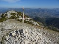
(8) At the “Col de Sanguinet” signpost, take in the panoramic view and head towards the Ubac de Vercoiran on the right to reach the actual topographical pass.
(9) At the pass, turn right onto the path descending along the hillside towards the north. Stay on the main track as it cuts across towards the north-west, still through woodland, then follow the cherry orchards and begin a series of hairpin bends. Join a track suitable for vehicles and, after another series of hairpin bends, arrive at a junction leading to the Champagne farm.
(10) Turn left onto the tarmac road to continue the descent until you reach a junction with a path.
(11) At the signpost marked ‘l’Ubac de Vercoiran’, leave the track to the left and continue towards the hamlet of Colombrette.
(12) At the entrance to the hamlet, take the path that descends steeply to the right (dead end), then the grassy path to the right before the first house. Head down towards the Ruisseau des Vignes and cross it. Ignore the two tracks leading uphill to the right and continue along the path as close as possible to the stream. You will reach another small tarmac road; follow it to the right. Carry on, leaving the Chemin de Grange La Cour on your right.
(13) Pass the Chemin de la Rochette on your right and continue along the Impasse de Sainte-Luce. At the hairpin bend immediately before reaching the (renovated) Sainte-Luce property, take a small path up the embankment on the right which climbs steeply eastwards along a small ridge. Follow this, then head up alongside a large cultivated plot (lavender).
(14) You’ll reach a track that runs along the hillside above Sainte-Euphémie-sur-Ouvéze, then descends directly to the original junction.
(1) Turn left onto the path you took on the way out, cross the Ouvèze again and head back to the village (S/E).

 Visorando Member

 Difficult