To refuge de Tré la Tete

A circular walk from Les Contamines Montjoie up to the Refuge de tré la Tete and views of the Tré la Tete glacier, then descending to Combe Noire to the waterfalls before returning past the pretty chapel of Notre Dame de la Gorge.

Details

2257724
Creation:
Last update:
Last review:
  • Walking
    Activity: Walking
  • ↔
    Distance: 8.48 mi
  • ◔
    Average duration: 6h 15 
  • ▲
    Difficulty: Moderate

  • ⚐
    Back to start: Yes
  • ↗
    Ascent: + 2,690 ft
  • ↘
    Descent: - 2,684 ft

  • ▲
    Highest point: 6,463 ft
  • ▼
    Lowest point: 3,763 ft

Description of the walk

Use the car park in the village centre.

(S) From the village centre car park, walk south past the shops and church. As you leave the shops behind there will be a bridge on your right (12) continue along the road until it is possible to turn left and take a side road leading into a residential area with chalets.

(1) Turn left and follow the road past the chalets. The road curves left and up until it is possible to take a path across the grass to the edge of the woods. This is signposted.

(2) Take the well-marked and signposted path through the woods climbing in a series of zig-zags at first. These woods are a great place to pick wild bilberries in August. Eventually, you will emerge from the woods and ascend to the Refuge de tré la Tete. Refreshments are available to buy there.

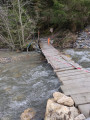
(3) From the Refuge de tré la Tete, continue in a south-westerly direction on the Tour du Pays du Mont-Blanc path and descend on a broad spur over open ground and then back into woodland. This will bring you down to the Cascades de Combe Noire and a bridge crossing the Torrent de tré la Tete.

(4) From the waterfalls, take the path through pastures among the woods passing the farm at la Laya and over another bridge to the valley bottom and the broad track.

(5) Turn right on the broad track and walk to the Pont de la Tena/Pont Romain.

(6) Continue along the path and descend over some rocky slabs to a bridge on the left. This leads to the chapel of Notre-Dame de la Gorge. The baroque chapel is well worth a visit.

(7) Walk back towards the bridge and take the path beside the river before you cross it. Walk with the river on your right passing the car parks for the chapel an towards the Pontet leisure park. The path passes with the campsite on your left and the leisure park on your right. Continue to a bridge and roundabout.

(8) Turn right and cross the bridge, then take the road bending left and follow this until to a zebra crossing where the path goes into some trees.

(9) Follow the path through the trees and back to the river, walk with it on your left to another bridge.

(10) Cross the bridge and follow the riverside path again with the river on your right. This brings you to a footbridge.

(11) Cross the footbridge and take the road bridge.

(12) Follow the footpath back into the village, passing the shops and walk back to the car park (S/E)


Waypoints

  1. S/E : mi 0 - alt. 3,780 ft - Car park
  2. 1 : mi 0.6 - alt. 3,812 ft
  3. 2 : mi 0.92 - alt. 3,944 ft
  4. 3 : mi 3.38 - alt. 6,463 ft - Refuge de tré la Tete
  5. 4 : mi 4.59 - alt. 4,849 ft - Cascades de Combe Noire - Cascades de Combe Noire
  6. 5 : mi 5.12 - alt. 4,633 ft
  7. 6 : mi 5.18 - alt. 4,557 ft - Pont de la Tena - Pont de la Téna (pont romain)
  8. 7 : mi 6.01 - alt. 3,960 ft - Notre-Dame de la Gorge - Notre Dame de la Gorge
  9. 8 : mi 7.22 - alt. 3,822 ft - Bridge
  10. 9 : mi 7.4 - alt. 3,819 ft
  11. 10 : mi 7.55 - alt. 3,806 ft - Bridge
  12. 11 : mi 7.96 - alt. 3,770 ft - Footbridge
  13. 12 : mi 8.01 - alt. 3,773 ft
  14. S/E : mi 8.48 - alt. 3,780 ft - Car park

Notes

Nicely shaded from the sun whilst in the woods.
Refreshments available at the Refuge de Tre la Tete

The path is well marked and well-travelled. It is possible in light walking boots or good approach shoes.

Please note this walk can be extended with :
- Lacs Jovet out and Return
- Col de la Fenetre
- Traverse of Mont Joly and Aiguille Croche

These walks can be combined to make longer and more challenging walks. For example, from the waterfalls, you could go up to the Lacs Jovet or up and over the Col de la Fenetre.

Alternatively, you could start on one of the other walks and finish using this one in reverse, from the waterfalls.

This route passes through multiple protected areas, which may be subject to special regulations:

Reviews and comments

4.8 / 5
Based on 3 reviews

Reliability of the description
4.7 / 5
Ease of following the route
4.7 / 5
Route interest
5 / 5
Alwayswiththehills
Alwayswiththehills

Hi
Thanks for your comments which build on those of other walkers. I will amend the description to start from the car park and will add your notes re the Chemin Bernard.
Kind regards
Mark

User 30724388

Overall rating : 4.3 / 5

Date of your route : Aug 22, 2026
Reliability of the description : ★★★★☆ Good
Ease of following the route : ★★★★☆ Good
Route interest : ★★★★★ Very good
Very busy route : No

As another commenter said, there’s no point setting off from Les Contamines. We parked at the Tré la Tête car park (easy to find on Waze). We walked uphill past the chalets (in the opposite direction to Notre-Dame-de-la-Gorge) and then set off towards Tré la Tête, which is clearly signposted at the top. It was a pleasant walk uphill through the woods. The wild blueberries are yuck. Well before the refuge, there’s a fork in the path: you can go to Tré la Tête either through the forest or via the Chemin Bernard. As we’d just spent quite a bit of time in the forest, I took the Chemin Bernard and I’m glad I did – it’s magnificent; the most beautiful part of the walk. At the refuge (landmark 2), there’s more to do than just have a drink; they serve meals, desserts and so on. You can indeed head towards the glacier—or what’s left of it—which is quite pretty. After that, the descent towards the Combe Noire is quite technical and should be avoided in wet weather. The waterfall is nice, but nothing special. As for the rest of the walk, it’s of no particular interest, apart from the Roman bridge. You’d probably be better off returning to the car park via the path that branches off at the Combe Noire waterfall (marker 4) towards the Combe Noire chalets and then La Sololieu, and from there head back down to the Tré la Tête car park along the mountainside, avoiding the leisure centre and so on.

Machine-translated

Zoltic
Zoltic

Overall rating : 5 / 5

Date of your route : Aug 06, 2026
Reliability of the description : ★★★★★ Very good
Ease of following the route : ★★★★★ Very good
Route interest : ★★★★★ Very good
Very busy route : Yes

The suggested starting point in the village centre makes no sense! It adds 2 × 1.5 km of tarmac for absolutely no reason. It’s better to use the car park at the leisure centre or at Notre-Dame-de-la-Gorge (right at the bottom of the gorge).
The route can be done either way (the clockwise direction is clearly busier).
In the suggested direction, there’s a steep, rather earthy climb. The descent is quite rocky, with some sections consisting of steps.
The route is almost entirely shaded by trees, which is very pleasant in bright sunshine. However, a few clearings offer some lovely views.
There is a water point at the Tré-la-tête refuge.
The glacier is a long way off, but climb the 20 metres up to the promontory above the refuge for a 360° panorama.

Machine-translated

chatonenrando
chatonenrando

Overall rating : 5 / 5

Date of your route : Jul 13, 2026
Reliability of the description : ★★★★★ Very good
Ease of following the route : ★★★★★ Very good
Route interest : ★★★★★ Very good
Very busy route : No

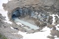
We actually set off from the Tré la Tête car park in Le Cugnon. The walk begins in the forest; it’s uphill but quite pleasant. The approach to the refuge takes you over rocky terrain, with some sections requiring a bit of a scramble. There’s a stunning view of the valley from the top. Once you’re up there, before heading down via the Combe Noire, take half an hour to climb up towards the Tré la Tête glacier by following the path towards Les Conscrits – the scenery is stunning and you might even spot some marmots! Even though the glacier isn’t really visible any more, the landscape is magnificent. The descent takes you through the heart of the forest and ends in the N-D Gorges, with some lovely sections. However, the final part of the walk is along a very busy path (Notre Dame de la Gorge, the riding centre, the campsite).

Machine-translated

Other walks in the area

For more walks, use our search engine .

The GPS track and description are the property of this route's author. Please do not copy them without permission.