Kong Waterfall on the Rivière du Pérou

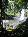
A magnificent waterfall on the Rivière du Pérou, located in the commune of Capesterre-Belle-Eau.

Details

n°62203391
Creation:
Last update:
Last review:
  • Walking
    Activity: Walking
  • ↔
    Distance: 5.24 mi
  • ◔
    Average duration: 3h 45 
  • ▲
    Difficulty: Difficult

  • ⚐
    Back to start: Yes
  • ↗
    Ascent: + 1,529 ft
  • ↘
    Descent: - 1,522 ft

  • ▲
    Highest point: 2,093 ft
  • ▼
    Lowest point: 965 ft

Description of the walk

At Capesterre-Belle-Eau, follow the Route des Concessions to its end.

(S/E) Take the path on the right and head towards the Rivière du Pérou.

(1) Turn left to head upstream along the river: the going is difficult as there is no marked path and great caution is required. Avoid this route at all costs in heavy rain. Reach Kong Waterfall.

(2) Turn back and follow the ascent route in the opposite direction, remaining vigilant at all times, to return to the end of the Route des Concessions (S/E).

Waypoints

  1. S/E : mi 0 - alt. 1,240 ft - End of the Route des Concessions
  2. 1 : mi 0.24 - alt. 965 ft - Peru River
  3. 2 : mi 2.62 - alt. 2,093 ft - Kong Waterfall
  4. S/E : mi 5.24 - alt. 1,240 ft - End of the Route des Concessions

Worth a visit

Kong Waterfall.

Reviews and comments

4.3 / 5
Based on 2 reviews

Reliability of the description
4 / 5
Ease of following the route
4 / 5
Route interest
5 / 5
Svnti
Svnti

Overall rating : 4.3 / 5

Date of your route : Mar 09, 2025
Reliability of the description : ★★★★☆ Good
Ease of following the route : ★★★★☆ Good
Route interest : ★★★★★ Very good
Very busy route : No

The hike is really long; allow 10 hours for the round trip, not 3 hours 45 minutes as stated. The path can be tedious in places, verging on rock climbing. The waterfall is magnificent and well worth the effort; for me, it’s the most beautiful in Guadeloupe. You should definitely avoid this hike if it’s raining or if it has rained in the previous days, as you’ll be completely stuck if the river swells – you’ll be walking between walls of vegetation that are sometimes 30–40 metres high.
There are absolutely no signposts; you have to make your way up the river by trial and error, and in case you’re wondering, yes, you do have to climb over a gate to get there…

Machine-translated

milorfila
milorfila

Overall rating : 4.3 / 5

Date of your route : Dec 30, 2024
Reliability of the description : ★★★★☆ Good
Ease of following the route : ★★★★☆ Good
Route interest : ★★★★★ Very good
Very busy route : No

A long approach along the river over slippery rocks, involving a bit of climbing. Allow 3 hours for experienced hikers. Do not attempt this if rain is forecast, as there are few places to take shelter. You’ll be rewarded with two stunning waterfalls.

Machine-translated

Other walks in the area

For more walks, use our search engine .

The GPS track and description are the property of this route's author. Please do not copy them without permission.