Carladez - The Laussac Peninsula.

This hike, leading from the Thérondels plateau to the wooded slopes of the Truyère, offers a bird's eye view of the narrow "fjord" formed by the Sarrans Lake reservoir. The Laussac peninsula and its splendid chapel are one of the most iconic sites in Carladez, north of Aveyron.

Details

2262762
Creation:
Last update:
Last review:
  • Walking
    Activity: Walking
  • ↔
    Distance: 15.16 km
  • ◔
    Average duration: 5h 30 
  • ▲
    Difficulty: Moderate

  • ⚐
    Back to start: Yes
  • ↗
    Ascent: + 414 m
  • ↘
    Descent: - 417 m

  • ▲
    Highest point: 952 m
  • ▼
    Lowest point: 649 m

Photos

Description of the walk

The route follows the yellowPR® markings and the mountain bike route no. 10.

(S/E) Depart from Place des Tilleuls, near the mini-market. Take the D18 lined with lime trees towards Brommat.

(1) At the first crossroads (stone cross), leave the Sentier de l'Imaginaire trail on your right. Take the path on the left heading south for about 2 km, which joins the D139 after Pervilhergues.

(2) Cross the D139 with caution and take the path opposite, which descends to the edge of the road.

(3) On the descent, take the path on the right and climb back up towards the D139. Take care. Follow it to the left and cross Jou.

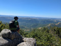
(4) On leaving Jou, leave the D139 at the "travail du maréchal ferrant" (farrier's workshop) and turn left onto the path that descends towards the D98 and the Laussac peninsula. There are numerous viewpoints over the Sarrans reservoir.

(5) Take care. Cross the D98 twice to cut the bend. Continue along the very steep path and finally down a steep descent to join the D98. First turn left then right to reach the peninsula.

(6) On the peninsula, take the small road on the right, pass the chapel on the left, then turn right onto the lane that goes downhill. At the bottom, turn left onto the road that leads to the beach. Swimming is possible and there are picnic tables.

(6) Turn right onto the road towards the car park. Join the D537 via the car park.

(7) Take care. Cross the D537 and take the path opposite that runs above the road to the Devèze bridge.

(8) Do not cross the bridge, but turn left onto the forest track that climbs towards the plateau and joins the track that comes from the Estradié bridge and arrives near Banes.

(9) Continue left on this track heading due north. Join the D236. Caution. Turn left and follow it for 200 metres.

(10) Before Banes, turn right onto the paved path that cuts across a bend in the road, then turn right and follow it for 200 metres. Take care.

(11) Turn left onto the path that climbs towards Thérondels. Pass the Couderc cross and Rue du Cayrol on your right to reach the village centre. At the crossroads between the church and the town hall, turn left onto Rue de la Mairie and continue to Place des Tilleuls (S/E).

Waypoints

  1. S/E : km 0 - alt. 950 m - Place des Tilleuls
  2. 1 : km 0.56 - alt. 948 m - Leave the D18, take the left-hand road
  3. 2 : km 3.15 - alt. 904 m - Crossing the D139
  4. 3 : km 3.72 - alt. 858 m - Track on the right uphill
  5. 4 : km 4.6 - alt. 889 m - Exit Jou, on the left
  6. 5 : km 5.93 - alt. 765 m - 2 crossings of the D98
  7. 6 : km 6.48 - alt. 659 m - Laussac Peninsula - Truyère (rivière)
  8. 7 : km 7.75 - alt. 668 m - Crossing the D537
  9. 8 : km 8.32 - alt. 652 m - Devèze Bridge - Brezon (rivière) - Affluent de la Truyère
  10. 9 : km 11.97 - alt. 730 m - Turn left onto the track heading due north.
  11. 10 : km 13.44 - alt. 848 m - Entrance to Banes
  12. 11 : km 14.05 - alt. 901 m - Path on the left
  13. S/E : km 15.16 - alt. 950 m - Place des Tilleuls

Worth a visit

In Thérondels:
- Its cheese cooperative, famous for its raw milk cheeses. (Cantal AOP, aligot, Thérondels)
- Its Romanesque church.
- Its "Imagination Trail" entitled "And the farmer created the meadow".

The Laussac Peninsula:
- Its village, its chapel (not always open, with altarpieces and relics of Saint Gausbert), and its beach.

The Sarrans dam built on the Truyère river has shaped the landscape, creating a "bridge" between Carladez, Aubrac and Viadène. (start of construction: 1928 – filling: 1934)

 Always be cautious and plan ahead when you're outdoors. Visorando and the author of this route cannot be held responsible for any accidents occurring on this route.

The GR® and PR® markings are the intellectual property of the Fédération Française de Randonnée Pédestre.

Reviews and comments

4.6 / 5
Based on 10 reviews

Reliability of the description
4.9 / 5
Ease of following the route
4.9 / 5
Route interest
4 / 5
Pierrot1704
Pierrot1704

Overall rating : 5 / 5

Date of your route : Oct 06, 2025
Reliability of the description : ★★★★★ Very good
Ease of following the route : ★★★★★ Very good
Route interest : ★★★★★ Very good
Very busy route : No

We did the hike in sunny weather, but the rain that fell two days earlier made some parts of the route difficult to navigate (mainly on the way back), which are used for 4x4, quad bike and other motorbike rodeo courses. So, whenever possible, I used the road, even if it meant a slightly longer journey.
I used a GPS, but the directions were good, so no problems.
The peninsula and the lake are very pretty to visit and see.
I recommend it, but not if it is raining or has rained recently.

Machine-translated

DELBES
DELBES

Overall rating : 5 / 5

Date of your route : Aug 15, 2025
Reliability of the description : ★★★★★ Very good
Ease of following the route : ★★★★★ Very good
Route interest : ★★★★★ Very good
Very busy route : No

A beautiful route on a hot August day.
We started the hike at the start of the Laussac peninsula. The climb up to the Thérondels plateau is along a magnificent shaded trail!
The rest of the hike is very pleasant (beautiful 360-degree panoramic views)
The only slight downside is the fairly steep descent between points 5 and 6
Note: the trail and tracks are remarkably well maintained throughout!
A beautiful hike! Highly recommended

Machine-translated

User 10467109

Overall rating : 4.7 / 5

Date of your route : Jul 21, 2025
Reliability of the description : ★★★★★ Very good
Ease of following the route : ★★★★★ Very good
Route interest : ★★★★☆ Good
Very busy route : Yes

very beautiful route, return to Thérondels a little long

Machine-translated

Inaya
Inaya

Overall rating : 4.7 / 5

Date of your route : Sep 14, 2024
Reliability of the description : ★★★★★ Very good
Ease of following the route : ★★★★★ Very good
Route interest : ★★★★☆ Good
Very busy route : No

Please note that the point encoded in the "go to start" option takes you to point 1 and not to the start, but just follow the road to get to the car park.
A pleasant walk, all downhill to Laussac and therefore all uphill on the way back. The gradients are fairly gentle. Unlike other comments, I preferred the return journey to the outward one, as it was more wooded. Few views except for the lake. But nice.

Machine-translated

Phil et Pascale
Phil et Pascale

Overall rating : 4.7 / 5

Date of your route : Aug 23, 2024
Reliability of the description : ★★★★★ Very good
Ease of following the route : ★★★★★ Very good
Route interest : ★★★★☆ Good
Very busy route : Yes

Very nice hike, but I only rated it "good" for interest, not for the whole thing, but for the return trip, which seemed a bit long because it was more monotonous, especially on the forest trail.

Machine-translated

randovolant
randovolant

Overall rating : 4.7 / 5

Date of your route : Sep 21, 2023
Reliability of the description : ★★★★★ Very good
Ease of following the route : ★★★★★ Very good
Route interest : ★★★★☆ Good
Very busy route : No

A route to do once, completed on 21 September 2023. On that day, I didn't see anyone, but it may not be the same in summer. No major difficulties except perhaps in rainy weather (cobblestones, among other things).
There is the possibility of swimming on the peninsula.

Machine-translated

Isard63
Isard63

Overall rating : 4.7 / 5

Date of your route : May 26, 2022
Reliability of the description : ★★★★★ Very good
Ease of following the route : ★★★★★ Very good
Route interest : ★★★★☆ Good
Very busy route : No

A pleasant, easy, shaded walk, with the added bonus of the pretty little village of Laussac. We shortened the circular route by leaving and returning to Jou via the well-marked path that climbs back up into the woods before the Catainères stream and leads to point 3.

Machine-translated

fdpb
fdpb

Overall rating : 4.7 / 5

Date of your route : Dec 22, 2021
Reliability of the description : ★★★★★ Very good
Ease of following the route : ★★★★★ Very good
Route interest : ★★★★☆ Good
Very busy route : No

Circular starting from the peninsula, ending with the descent
Very pleasant. Great views, but don't miss them as there aren't many (most of the trail is in the forest, especially on the climb to Thérondels).
Thanks to the author of the route!

Machine-translated

Carodadou
Carodadou

Overall rating : 4 / 5

Date of your route : Jul 18, 2021
Reliability of the description : ★★★★★ Very good
Ease of following the route : ★★★★★ Very good
Route interest : ★★☆☆☆ Disappointing
Very busy route : No

The route took place on a windy day, but we were sheltered for almost the entire route.
The first half of the route to the Laussac peninsula was pleasant. There were a few views of the lake.
I recommend stopping for a picnic on the peninsula, as there are no other interesting places to stop afterwards.
The return journey along the forest path is long and monotonous, with NO views of the Truyère river, as there are too many trees! It's a shame.

Machine-translated

fantom-as
fantom-as

Overall rating : 4 / 5

Date of your route : Aug 18, 2020
Reliability of the description : ★★★★☆ Good
Ease of following the route : ★★★★☆ Good
Route interest : ★★★★☆ Good
Very busy route : No

In rainy weather, the climb can be difficult:
Mud between 7 and 9
Slippery stones between 10 and 11

Machine-translated

Other walks in the area

For more walks, use our search engine .

The GPS track and description are the property of this route's author. Please do not copy them without permission.