Caesar’s Camp in Lignaud

Following in the footsteps of ancient Roman roads, this route takes you to the northern plateau of Lignaud, a village rich in traces of the past. You’ll walk through meadows, farmland and coniferous woodland, skirting the plots of the ‘Camp de César’, whose cadastral layout reveals the characteristics of a Roman camp. There is a significant amount of historic architecture in the heart of the village.

Details

1405976
Creation:
Last update:
Last review:
  • Walking
    Activity: Walking
  • ↔
    Distance: 2.76 mi
  • ◔
    Average duration: 1h 20 
  • ▲
    Difficulty: Easy

  • ⚐
    Back to start: Yes
  • ↗
    Ascent: + 69 ft
  • ↘
    Descent: - 75 ft

  • ▲
    Highest point: 1,093 ft
  • ▼
    Lowest point: 1,014 ft

Photos

Description of the walk

To reach the village of Lignaud: take the D951 towards Dun-le-Palestel. Before Chambon-Sainte-Croix, take the road leading uphill to the right just before the bridge over the Petite Creuse.

LSP 5: Village of Lignaud (car park at the communal grounds at the top of the village, crossroads, wooden cross, bottle recycling bin)
(S/E) Set off to the right along the path that runs alongside a metal shed. At the track, turn right, then left onto the road, and take the track opposite

(1) On the track, turn left onto the first path (an old Roman road) and follow it straight on until you reach a small road.

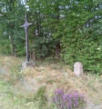
(2) At the road, turn right for about 50 metres, until you reach a wooden cross and a Gallo-Roman boundary stone. Retrace your steps and follow the road to the first path on the right.
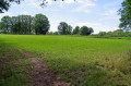
The plots on the right are known as ‘Caesar’s Camp’. Their layout and arrangement correspond in every respect to those of a Roman camp

(3) Take the first path on the right which leads into the coniferous woodland; follow it.

(4) Turn left onto the first forest track, then turn left again to enter the woodland, following the edge until you reach a wide track.

(5) Take this path to the left and it will lead you back to the starting point.

You’ll arrive at the communal car park at the top of the village (S/E).

Waypoints

  1. S/E : mi 0 - alt. 1,060 ft - Car park – communal grounds at the top of the village
  2. 1 : mi 0.57 - alt. 1,043 ft - Turn left onto the main path
  3. 2 : mi 1 - alt. 1,093 ft - Turn left onto the road (50m further on, on the right, there is a cross and a boundary marker)
  4. 3 : mi 1.3 - alt. 1,056 ft - Main path to the right
  5. 4 : mi 1.72 - alt. 1,040 ft - Forest track on the left
  6. 5 : mi 2.03 - alt. 1,017 ft - Main path to the left
  7. S/E : mi 2.76 - alt. 1,060 ft - Car park – communal grounds at the top of the village

Notes

Yellow markings and directional signposts

Worth a visit

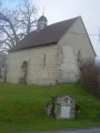
A walk through the village of Lignaud, rich in historic architecture.

Reviews and comments

3.6 / 5
Based on 6 reviews

Reliability of the description
3.8 / 5
Ease of following the route
3.4 / 5
Route interest
3.5 / 5
User 28824119

Overall rating : 3 / 5

Date of your route : Mar 30, 2026
Reliability of the description : ★★★☆☆ Average
Ease of following the route : ★★★☆☆ Average
Route interest : ★★★☆☆ Average
Very busy route : No

Machine-translated

Nemo31
Nemo31

Overall rating : 3 / 5

Date of your route : Jul 04, 2022
Reliability of the description : ★★★★★ Very good
Ease of following the route : ★★☆☆☆ Disappointing
Route interest : ★★☆☆☆ Disappointing
Very busy route : No

First of all, I’d like to make it clear that I’m aware the author of this guide is not responsible for the disastrous state of the footpaths in France.
1) I chose ‘disappointing’ to describe how easy it was to follow the route, because at point 4 the forest track no longer exists.
The woodland has been completely cleared and the ground churned up by machinery. All that remains are stumps and a pile of branches, of varying sizes, scattered about and tending to pile up at the edges – and thus on what may, perhaps, be the remains of the path.
The ground is overrun with very aggressive brambles.
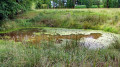
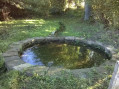
To continue the walk, you have to go under the barbed wire to enter the field on the right. Then go round the pond, passing in front of the drinking trough, and rejoin the wide path in the left-hand corner of the field by going under the barbed wire again.
2) I chose ‘disappointing’ to describe the route’s appeal because it only offers views of cultivated fields, just like everywhere else. ‘Caesar’s camp’ is nowhere to be seen, except perhaps from the air. Seen from the ground, it’s a myth.

Machine-translated

cinthialew
cinthialew

Overall rating : 4 / 5

Date of your route : Nov 30, 2020
Reliability of the description : ★★★☆☆ Average
Ease of following the route : Not used / Not applicable
Route interest : ★★★★★ Very good
Very busy route : No

Lignaud is a large village; we had trouble finding the starting point, which isn’t very obvious. It would be helpful to mention that there’s a bottle recycling bin where you park.

Then, at the point where you need to turn left onto the path (the old Roman road), for people who get caught up in conversation and forget to follow the yellow arrow as well, it would be helpful to specify that you should turn left at the first path. As the instructions say to go straight on until you reach a small road, we followed the path straight on until we reached the main road leading to Chambon-Sainte-Croix. So we missed the first path on the left.

Otherwise, the entrance to the coniferous woodland is really very wild and lovely.

Machine-translated

sailly jerome
sailly jerome

Overall rating : 3.7 / 5

Date of your route : Oct 31, 2019
Reliability of the description : ★★★★★ Very good
Ease of following the route : ★★★☆☆ Average
Route interest : ★★★☆☆ Average

The first part of this route is pleasant; it’s a shame that the section before marker number 5 is impassable – you have to make your way through the felled section of the forest, through the brambles, to rejoin the rest of the route.

Machine-translated

marchalombre3
marchalombre3

Overall rating : 4.3 / 5

Date of your route : Apr 07, 2019
Reliability of the description : ★★★★☆ Good
Ease of following the route : ★★★★★ Very good
Route interest : ★★★★☆ Good

The walk was short but enjoyable. The section through the forest between points 4 and 5 is made a little tricky by the numerous tree trunks lying on the ground (in April 2019), and at first you might hesitate a little about heading in that direction. The route markings and description are good – thank you.

Machine-translated

Olivier Robreau
Olivier Robreau
• Edited:

Overall rating : 3.7 / 5

Date of your route : Jun 02, 2019
Reliability of the description : ★★★☆☆ Average
Ease of following the route : ★★★★☆ Good
Route interest : ★★★★☆ Good

First of all, the communal land is on the outskirts of the village. Secondly, the path isn’t maintained, and worst of all, a company is felling trees and has failed to leave a path between points 4 and 5. What makes it hardest for the 5-year-old (having to make her way through the brambles) is a shame, because the rest of it is lovely!!

Machine-translated

Other walks in the area

For more walks, use our search engine .

The GPS track and description are the property of this route's author. Please do not copy them without permission.