The Cabouy circular from Rocamadour

A lovely, well-rounded route, though you’ll need to keep your bearings at times as the paths are overgrown.
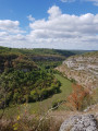
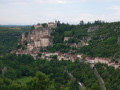
Stunning scenery and a walk through Rocamadour that’s not to be missed.

Details

n°1803736
Creation:
Last update:
Last review:
  • Walking
    Activity: Walking
  • ↔
    Distance: 12.26 mi
  • ◔
    Average duration: 7h 30 
  • ▲
    Difficulty: Moderate

  • ⚐
    Back to start: Yes
  • ↗
    Ascent: + 2,172 ft
  • ↘
    Descent: - 2,185 ft

  • ▲
    Highest point: 951 ft
  • ▼
    Lowest point: 358 ft
  • ⚐ Country: France
  • ⚐ City: Rocamadour (46500)
  • ⚑
    Start/End: N 44.791057° / E 1.583748°
  • ❏
    IGN map(s): Ref. 2136ET, 2137E, 2137O
  • Hour-by-hour weather

Photos

Description of the walk

From Rocamadour, head towards the Gouffre de Cabouy, where there is a car park.

(S/E) From the car park, head towards the Gouffre de Cabouy.

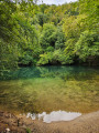
(1) Take the path on your left when you’re in front of the Cabouy resurgence

(2) Turn left and walk up the Combe Longue. Ignore the path on the right.

(3) Cross the D32 and join theGR® 46, which heads off to the left. Cross the D32 again.

(4) Berthiot fountain – a chance to cool off.

(5) Cross the small road to begin your climb up to Rocamadour, which will take you to the summit near the castle. Continue towards the large car park, then follow the Route du Château. Leavethe GR®46.

(6) Follow the ridge to L’Hôspitalet via the Route du Château (D200) and then the D36. Take care.

(7) Head back down into the valley at the foot of Rocamadour, turning right onto the Voie Sainte. Join the D32 and continue to the right. At the car park, follow the hairpin bend to the left, then take a path that leads down to the streets and car parks below. Turn left, then rejoin the D32 to the right. Take care. Cross the Alzou.

(8) Take the path that climbs to the left for 1,500 metres towards Saint-Cirq-Lapopie.

(9) Turn right to join the small tarmac road (altitude 275 m); follow it to the right for 50 m, then take the track branching off to the left. Follow it all the way down; it will eventually fade away a few metres before the valley floor. Cross the D32 and head left.

(10) Cross the main track and head up the valley on the left through the woods along theGR®46.

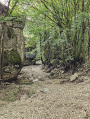
(11) Please note: (Altitude 258m) turn right onto a path that isn’t clearly marked; you must stay on the right-hand side of the valley to find the remains of an old track. Once you reach the top, the path becomes more visible, but you’ll need to step off it from time to time to avoid the overgrown vegetation.

(12) Le Barry. Cross the two roads and, after 100m, turn right onto the track that descends and runs alongside the D39.

(13) At the crossroads, turn right, then immediately left uphill. Continue straight on, ignoring the various adjacent paths. Pass through Les Granges de Bonnecoste. Pass a road junction (altitude 265m) and continue for 150m.

(14) Take the track on the right which descends towards the Gouffre de Saint-Sauveur resurgence.

(15) A return trip to the Gouffre de Saint-Sauveur resurgence will allow you to cool off in summer. To do this, go through the gate; you’ll find the resurgence 50 metres down the slope.
Alternatively, continue along the path to the right, following the Ouysse.

(16) Walk behind the Gouffre de Cabouy resurgence to cross the Ouysse.

(1) Turn left towards the car park (S/E).

Waypoints

  1. S/E : mi 0 - alt. 390 ft - Cabouy Chasm car park - Ouysse (rivière)
  2. 1 : mi 0.05 - alt. 364 ft - The same junction is used for both the outward and return journeys.
  3. 2 : mi 0.74 - alt. 407 ft - To the left
  4. 3 : mi 1.47 - alt. 846 ft - Cross the road and turn left onto the GR46
  5. 4 : mi 2.35 - alt. 476 ft - Berthiot Fountain
  6. 5 : mi 2.48 - alt. 456 ft - Cross the small road. Head uphill
  7. 6 : mi 3.09 - alt. 866 ft - Route du Château
  8. 7 : mi 3.67 - alt. 827 ft - Turn right onto the Voie Sainte
  9. 8 : mi 4.22 - alt. 459 ft - Head towards Saint-Cirq-Lapopie after the - Alzou (rivière)
  10. 9 : mi 5.24 - alt. 938 ft - On the right: a chasm
  11. 10 : mi 6.32 - alt. 607 ft - Turn left. GR46
  12. 11 : mi 6.8 - alt. 846 ft - Turn right. Altitude: 258m
  13. 12 : mi 7.33 - alt. 938 ft - Le Barry. Straight on
  14. 13 : mi 9.16 - alt. 554 ft - Right, left
  15. 14 : mi 10.42 - alt. 830 ft - Turn right onto the track
  16. 15 : mi 11.16 - alt. 407 ft - Resurgences of the Gouffre de Saint-Sauveur
  17. 16 : mi 12.13 - alt. 358 ft - Walk behind the Gouffre de Cabouy resurgence
  18. S/E : mi 12.26 - alt. 390 ft - Cabouy Chasm car park

Notes

Rocamadour is far from peaceful during the summer tourist season.
There are sections on the Causse – be careful in hot weather.

Worth a visit

A lovely little route that requires a bit of a sense of direction as the paths are somewhat overgrown.
Very beautiful scenery and a walk through Rocamadour that’s not to be missed.

Always be cautious and plan ahead when you're outdoors. Visorando and the author of this route cannot be held responsible for any accidents occurring on this route.

The GR® and PR® markings are the intellectual property of the Fédération Française de Randonnée Pédestre.

Reviews and comments

3.2 / 5
Based on 3 reviews

Reliability of the description
2.7 / 5
Ease of following the route
2.7 / 5
Route interest
4.3 / 5
Vanessalx
Vanessalx

Overall rating : 2.7 / 5

Date of your route : Aug 18, 2024
Reliability of the description : ★★☆☆☆ Disappointing
Ease of following the route : ★☆☆☆☆ Very disappointing
Route interest : ★★★★★ Very good
Very busy route : No

Beautiful scenery, but a walk that wasn’t signposted at all.
We followed the comments to help us get out of the valley floor at point 13.
This hike is best approached as a treasure hunt, with fully charged mobile phones.

Machine-translated

Celineetfrederic
Celineetfrederic

Overall rating : 3.3 / 5

Date of your route : May 26, 2022
Reliability of the description : ★★★☆☆ Average
Ease of following the route : ★★★☆☆ Average
Route interest : ★★★★☆ Good
Very busy route : No

The walk is very scenic. Rocamadour is, of course, spectacular, but the rest of the route, which is varied, is also very interesting, with its turquoise-coloured springs, gorges and low stone walls.
The problems aren’t at point 11, as stated in the description. You leave the GR 46 via a clearly marked path that branches off to the right.
It is just before point 13 that this walk becomes impossible to follow without a GPS app. This is because the route of the paths has been altered. To find this point, we used the GPS to guide us, leaving the path and following narrow tracks. Once we reached point 13, the path described in the route description is the one marked by an orange cross. It is overgrown with scrub, trees, crumbling low walls and brambles. Once again, we had to use the GPS to find our way. Furthermore, we were unsettled by the incessant sound of gunfire coming from our left. The ‘path’ was, in fact, littered with cartridge cases. A resident of the village just before point 14 explained to us that it was a clay pigeon shooting range, open every day.
We reached Point 14 via the road and, from there, had no further problems.
We covered 23 km with these detours.
The path is not very busy, but Rocamadour is teeming with people, and there are also crowds at the Cabouy and Saint Sauveur springs.
In summary, a lovely walk, but one you shouldn’t attempt without a GPS app or IGN maps to find alternative routes between points 12 and 14.

Machine-translated

murielalloyer
murielalloyer

Overall rating : 3.7 / 5

Date of your route : Aug 15, 2019
Reliability of the description : ★★★☆☆ Average
Ease of following the route : ★★★★☆ Good
Route interest : ★★★★☆ Good

A really lovely walk, with a beautiful finish in Rocamadour, which you walk through and then look down upon. And then, once you leave Rocamadour, it’s back to peace and quiet – we didn’t meet a single soul on 15 August!
The route is very clear up to marker 13. No problems at markers 10 and 11, contrary to what the guide says. However, we did encounter a few difficulties at marker 13. The guide doesn’t match up, but by following the route ‘roughly’, we didn’t have too much trouble finding our way back on track.
In short, take your GPS with you!

Machine-translated

Other walks in the area

For more walks, use our search engine .

The GPS track and description are the property of this route's author. Please do not copy them without permission.