Circular Walk of Vignes in Tillières

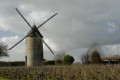
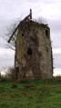
Set off to explore the Mauges countryside through its vineyards, its historical heritage – including Saint-Pierre Church – and the industrial heritage of the village of Tillières. Near the car park, you can admire an old mill dating from the 19th century.

Details

n°33847271
Creation:
Last update:
Last review:
  • Walking
    Activity: Walking
  • ↔
    Distance: 6.26 mi
  • ◔
    Average duration: 3h 00 
  • ▲
    Difficulty: Easy

  • ⚐
    Back to start: Yes
  • ↗
    Ascent: + 141 ft
  • ↘
    Descent: - 167 ft

  • ▲
    Highest point: 305 ft
  • ▼
    Lowest point: 197 ft
  • ⚐ Country: France
  • ⚐ City: Tillières (49230)
  • ⚑
    Start/End: N 47.152229° / W 1.162423°
  • ❏
    IGN map(s): Ref. 1323SB, 1324SB
  • Hour-by-hour weather

Photos

Description of the walk

From junction 4 on the N249, head towards Tillières, then continue straight on along the D223. Park in the Moulin Guillou car park.

Follow the green signposts.

(S/E) With your back to the mill, take the Route du Moulin Guillou on your right; then, at the junction, head down the D223 for about 1 km towards the village of Tillières, keeping to the left at all times. Pass the cemetery.

(1) At this junction, cross the D63 onto Rue du Pont Neuf. You’ll be able to see Saint-Pierre Church on your left. Carry on straight ahead until you reach the N249. Go under the N249 and continue straight on until you reach a four-way junction.

(2) Turn left, towards the hamlet known as “l’Aunay” (do not enter the hamlet itself), and you will reach a Y-junction.

(3) Turn right, towards “Maison Neuve”. When you reach this farm, turn right and drive through the farmyard to reach the junction with the D223.

(4) Cross the road and follow the path opposite, which passes through the hamlet of Le Tronc. Continue straight on at the junction with the next track, then keep right at the next one, to reach a four-way crossroads at La Grande Gaudinière.

(5) Carry on towards the hamlet known as La Petite Gaudinière. Follow the road at the end of the track. On the road, as you leave the hamlet, make the first turn right then left and continue through the vineyards until you reach the first bend.

(6) Turn right and follow this track for about 1 km until you rejoin the D63.

(7) Head off to your right for over 350 metres, then turn left at the next junction to pass under the N249.

(8) After crossing the bridge, go straight on towards “La Papinière” via Rue La Hurnière. Drive through the village, keeping to the left at every junction, until you reach the village exit.

(9) Turn right onto this final street. Take the left-hand turn at the next bend. Follow the track for 800 metres. Then turn left onto the next track and cross over the Ruisseau de la Braudière to reach another crossroads at a place called Le Parc.

(10) Turn left again and carry on straight ahead until you reach the road at a place called ‘La Grande Bihardière’. Turn right for 250 m and then left at the first bend. Follow the path to the D224.

(11) Complete the circular route by turning left, then taking the first track on the right to return to the Moulin Guillou car park (S/E).


Waypoints

  1. S/E : mi 0 - alt. 305 ft - Moulin Guillou car park - Le Moulin Guillou
  2. 1 : mi 0.61 - alt. 256 ft - Tillières
  3. 2 : mi 1.19 - alt. 285 ft - Four-way junction
  4. 3 : mi 1.35 - alt. 279 ft - Y-junction towards Maison-Neuve
  5. 4 : mi 2.12 - alt. 282 ft - D223
  6. 5 : mi 3.17 - alt. 240 ft - La Grande Gaudinière
  7. 6 : mi 3.79 - alt. 285 ft - A fork in the road at the bend
  8. 7 : mi 4.39 - alt. 279 ft - D63
  9. 8 : mi 4.68 - alt. 279 ft - Rue de la Hurnière
  10. 9 : mi 4.9 - alt. 262 ft - La Hurnière
  11. 10 : mi 5.38 - alt. 266 ft - A place known as ‘Le Parc’
  12. 11 : mi 6.06 - alt. 302 ft - Turn left to reach the car park - Le Moulin Guillou
  13. S/E : mi 6.26 - alt. 305 ft - Moulin Guillou car park - Le Moulin Guillou

Worth a visit

Moulin Guillou and its leisure area:
A two-storey tower mill built around 1860 and owned by the local council since 1978. It was restored in 1982. It is 11.50 m high and the tower has a diameter of 5 m. It is fitted with Berton sails with a span of 14 m and a pivoting roof that can be adjusted to face the prevailing winds. A picnic area and a car park have been provided near the mill.

Saint-Pierre Church: 1869–1870:
Designed by the architect Alfred Tessier de Beaupréau, this church was intended to be a scaled-down replica of the Church of Notre-Dame in Cholet. Built in the Neo-Gothic style, it features a central nave and two side aisles. The flying buttresses are supported by buttresses crowned with pinnacles. The windows on the side walls are pointed arches in the neo-18th-century style.
Above the arched entrance stands the bell tower with a stone spire and a sound deflector (a device with slats designed to direct the sound towards the bells). The long, narrow nave features ribbed vaults, rib segments and transverse ribs. The keystones are decorated and painted.
The overall design is largely inspired by the Rayonnant Gothic style.
A stained-glass window depicting Saint Peter is set at the back of the chancel. The high altar is adorned with a high relief depicting the Entombment of Christ. A painting depicting the Resurrection of Christ, dating from 1883, was painted by
Chéron, inspired by the original work by Carle Van Loo.
(Restored in 1994 with the support of the Maine-et-Loire General Council)

Tile and brickworks:
In 1870, Tillières had eight tile and brick kilns. A factory in Tillières supplied the thin ‘chantignolles’ bricks for the construction of the gardener’s house in the Parc de la Garenne Lemot in Clisson. The main innovation of the Clisson style lies in the use of bricks for the masonry of windows, string courses and cornices. Two production sites are still in operation.

Reviews and comments

3.7 / 5
Based on 3 reviews

Reliability of the description
3.7 / 5
Ease of following the route
3.3 / 5
Route interest
4 / 5
general11
general11
• Edited:

Overall rating : 3 / 5

Date of your route : Dec 28, 2025
Reliability of the description : ★★★☆☆ Average
Ease of following the route : ★★☆☆☆ Disappointing
Route interest : ★★★★☆ Good
Very busy route : No

The signage is very poor, ageing and difficult to see on the signs that have been put up. Follow the route with GPS, as there are many gaps at intersections. The Mauges tourist office must no longer have any funds for paint.
In my opinion, the route has many tarmac sections, but the location is commanding and offers beautiful views.

Machine-translated

Bobylapointe49
Bobylapointe49

Overall rating : 4 / 5

Date of your route : Jul 25, 2024
Reliability of the description : ★★★★☆ Good
Ease of following the route : ★★★★☆ Good
Route interest : ★★★★☆ Good
Very busy route : No

A pleasant route that can be enjoyed in any season thanks to the well-graveled paths. The only downside is around the ‘Maison Neuve’ farm, where the path is practically impassable due to the presence of tall brambles (which haven’t been cleared for a long time). The route description and map are essential, as there are no signposts in many places.

Machine-translated

manuuher
manuuher

Overall rating : 4 / 5

Date of your route : Jul 30, 2023
Reliability of the description : ★★★★☆ Good
Ease of following the route : ★★★★☆ Good
Route interest : ★★★★☆ Good
Very busy route : No

It might be a bit of a long drive at the start; we can’t wait for the walk to really get going.
You can have a picnic at the mill car park and top up your water bottles.
The green markings aren’t particularly visible, especially between points (3) and (4) at the “La Maison Neuve” farm, and between (10) and (11), where a waypoint would have been useful at the spot where you need to turn due north whilst the path continues southwards.

Machine-translated

Other walks in the area

For more walks, use our search engine .

The GPS track and description are the property of this route's author. Please do not copy them without permission.