Circular walk around the Sommets des Petites and Grosses Grues

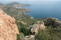
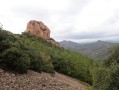
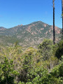
A lovely route offering fine views of the Bay of Cannes and the Bay of Saint-Raphaël. Varied vegetation, at times very damp or very dry.

Details

1249285
Creation:
Last update:
Last review:
  • Walking
    Activity: Walking
  • ↔
    Distance: 10.28 mi
  • ◔
    Average duration: 6h 30 
  • ▲
    Difficulty: Difficult

  • ⚐
    Back to start: Yes
  • ↗
    Ascent: + 1,998 ft
  • ↘
    Descent: - 1,998 ft

  • ▲
    Highest point: 1,440 ft
  • ▼
    Lowest point: 66 ft

Description of the walk

Park in the Col de Belle Barbe car park.

(S/E) Follow the forest track that forms part of theGR®653A, heading up the Ravin de Grenouillet until you reach the first ford.

(1) Head almost due north up the stunning Ravin du Mal Infernet

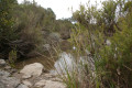
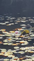
(2) Cross a second ford and reach the former Lac de l’Écureuil.

(3) Leave the track and take the path running alongside the dried-up lake to reach the northern end of the lake.

(4) Cross the first stream, the Ravin des Trois Termes, then a second at the Ravin de la Couche de l’Âne.
Once you reach the other side, rejoin the path and follow it uphill for a few metres until you reach a junction.

(5) Turn right onto theGR®51, following its white-and-red markings. Walk along almost level ground until you reach the Col Notre-Dame.

(6) Cross the car park and continue along theGR®51, leaving theGR®653Aon your right. Head for the Crête des Petits Trayas, then complete the short climb to the summit of the Petites Grues.

(7) Carry on along theGR® heading broadly north to reach the second summit, the Grosses Grues.

(8) Turn sharply left (90°) to quickly reach the Col de la Cadière.

(9) Take a sharp left turn onto the path leading to the Mamelon de la Source de la Cadière.

(10) Continue down the Ravin de la Cadière, which joins two other ravines further down:
- the Ravin des Grues,
- the Couche de l’Âne ravine.

(11) Turn right onto the latter, which further down rejoins the junction with theGR®51that you took earlier.

(5) Follow the same route back to reach the Col de Belle Barbe car park (S/E).

Waypoints

  1. S/E : mi 0 - alt. 148 ft - Car park - Col de Belle Barbe
  2. 1 : mi 0.66 - alt. 66 ft - Ford
  3. 2 : mi 1.92 - alt. 171 ft - Second ford
  4. 3 : mi 2.21 - alt. 253 ft - The dried-up Écureuil Lake
  5. 4 : mi 2.5 - alt. 226 ft - Trois Termes Stream
  6. 5 : mi 2.66 - alt. 246 ft - GR51 junction
  7. 6 : mi 4.34 - alt. 1,063 ft - Col Notre-Dame
  8. 7 : mi 4.87 - alt. 1,352 ft - Sommet des Petites Grues (413m)
  9. 8 : mi 5.35 - alt. 1,440 ft - Sommet des Grosses Grues
  10. 9 : mi 5.88 - alt. 784 ft - Col de la Cadière
  11. 10 : mi 6.3 - alt. 489 ft - Source de la Cadière
  12. 11 : mi 6.67 - alt. 387 ft - Couche de l’Âne Trail - Agay (fleuve)
  13. S/E : mi 10.28 - alt. 148 ft - Col de Belle Barbe car park

Always be cautious and plan ahead when you're outdoors. Visorando and the author of this route cannot be held responsible for any accidents occurring on this route.

The GR® and PR® markings are the intellectual property of the Fédération Française de Randonnée Pédestre.

Reviews and comments

4.7 / 5
Based on 2 reviews

Reliability of the description
4.5 / 5
Ease of following the route
4.5 / 5
Route interest
5 / 5
Omega26
Omega26

Overall rating : 4.3 / 5

Date of your route : Oct 25, 2023
Reliability of the description : ★★★★☆ Good
Ease of following the route : ★★★★☆ Good
Route interest : ★★★★★ Very good
Very busy route : No

. A really lovely route, with varied paths and terrain. Apart from at the dried-up lake, where there were a few wrong turns, but these were quickly rectified.

I did it to train for a trail run. It’s ideal. With lovely panoramic views.

Machine-translated

lesdecouvreurs
lesdecouvreurs

Overall rating : 5 / 5

Date of your route : Oct 13, 2018
Reliability of the description : ★★★★★ Very good
Ease of following the route : ★★★★★ Very good
Route interest : ★★★★★ Very good

It’s always a lovely route in fine weather, with sea views and a 360° panorama.

Given the rain over the previous few days, we were unable to cross the second ford at point no. 2. As a result, we took a longer route, turning right before the ford onto the start of the Ravin de l’Écureuil, then right again onto the Baisse des Sangliers, which led us to the Col des Lentisque, then on to the Col Notre Dame, and finally to the Petites and Grandes Grues. In total, around 19 km with an elevation gain of over 700 m, which we covered in 4 hours 30 minutes.

Well worth doing at any time of year, but avoid weekends and school holidays, as there are always plenty of walkers in this very popular tourist area.

Machine-translated

Other walks in the area

For more walks, use our search engine .

The GPS track and description are the property of this route's author. Please do not copy them without permission.