Circular route around Lussac

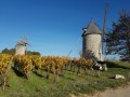
A very gently undulating route through vineyards, woodland and small hamlets.

Details

395822
Creation:
Last update:
Last review:
  • Walking
    Activity: Walking
  • ↔
    Distance: 5.10 mi
  • ◔
    Average duration: 2h 30 
  • ▲
    Difficulty: Easy

  • ⚐
    Back to start: Yes
  • ↗
    Ascent: + 217 ft
  • ↘
    Descent: - 240 ft

  • ▲
    Highest point: 276 ft
  • ▼
    Lowest point: 148 ft

Description of the walk

(S/E) D122 Stadium car park: walk round the eastern side, join the road on the right for 50 metres, then turn left and walk through Guimberteau. Take the next road on the right and, 20 metres further on, take the path on the left through the vineyards, crossing the D17 until you reach the T-junction.

(1) The path on the right takes you to the hamlet of Lucas. Cross the road and, keeping slightly to the left, pass between the houses to reach a tiny square. Go round the buildings on the right and continue south through the vineyards. Cross another property as you leave, turn left and continue until you reach the copse on your left.

(2) 50 m after the copse, turn right onto the path that joins the road, turn left onto the road, then take the first path on the right and, at the end of the vineyard, turn left twice until you reach the road.

(3) At “Les Doux” on the right, stay on the road, pass through Le Canton, then at the fork continue straight ahead on the D17 for 50 metres.

(4) Turn onto the first path on the right, enter the woods on the right, then turn left to follow the edge of the woods and take the path on the right, ‘Bois de Cadet’. Stay on the same path; after a 90° right-hand bend, follow the signs for ‘Le Coux’.

(5) At the hamlet of Le Coux, when you reach the road, turn left for 100 metres, then right towards Thomas and turn left at the first road. At the T-junction, turn right for 10 metres, then left to reach La Grange.

(6) Pass this hamlet and continue to the T-junction after a small pond on your right.

(7) Turn right and, 100 metres further on, turn left onto the path that runs alongside the woodland.

(8) At the end of the woodland, just before the next one, turn right, follow the woodland on your right and, at the exit, cross the vineyards to reach the woodland to the north.

(9) Take the path leading to the hamlet of Le Rival and the D22; turn right to reach the sports ground (S/E).


Waypoints

  1. S/E : mi 0 - alt. 259 ft - Sports ground car park
  2. 1 : mi 0.81 - alt. 249 ft - Path on the right towards Lucas
  3. 2 : mi 1.45 - alt. 197 ft - Turn right towards the road
  4. 3 : mi 1.85 - alt. 194 ft - Turn right onto the road towards Le Canton
  5. 4 : mi 2.33 - alt. 262 ft - Path on the right
  6. 5 : mi 3.06 - alt. 240 ft - Le Coux turns left
  7. 6 : mi 3.49 - alt. 194 ft - Turn left onto the road towards La Grange
  8. 7 : mi 3.87 - alt. 148 ft - T-junction: turn right
  9. 8 : mi 4.24 - alt. 190 ft - Turn right between two woods
  10. 9 : mi 4.71 - alt. 171 ft - Path on the left towards the D122
  11. S/E : mi 5.1 - alt. 259 ft - Sports ground car park

Notes

Important: it is strongly recommended that you either obtain the relevant IGN map or use the app on a smartphone, which will also allow you to be geolocated at all times, enabling you to track your progress accurately.

The route may cross or follow other signposted routes: unless otherwise stated, do not stray from the route and follow the path.

You will very often be crossing private property; please be discreet and respectful – this is the only way we can continue to offer routes like this.

Using walking poles can be very useful and reassuring. As well as providing stability, they help distribute the strain more evenly.

Reviews and comments

4.1 / 5
Based on 4 reviews

Reliability of the description
3.8 / 5
Ease of following the route
4 / 5
Route interest
4.5 / 5
anaiel
anaiel

Overall rating : 3.7 / 5

Date of your route : Aug 14, 2023
Reliability of the description : ★★★☆☆ Average
Ease of following the route : ★★★★☆ Good
Route interest : ★★★★☆ Good
Very busy route : No

A pleasant route around the village of Lussac with lovely views of the surrounding countryside.
Don’t miss the short detour to the Picampeau rock

Machine-translated

Piedsaterre
Piedsaterre

Overall rating : 4.3 / 5

Date of your route : May 15, 2023
Reliability of the description : ★★★★☆ Good
Ease of following the route : ★★★★☆ Good
Route interest : ★★★★★ Very good
Very busy route : No

In two places, we had to veer off the mapped route in order to continue. These were reported to the route planner, who was one of the walkers.

Machine-translated

delangeb
delangeb

Overall rating : 4.3 / 5

Date of your route : Feb 17, 2021
Reliability of the description : ★★★★☆ Good
Ease of following the route : ★★★★☆ Good
Route interest : ★★★★★ Very good
Very busy route : No

I’ve done this walk twice, in both directions. It’s very pleasant.
It’s a bit tricky to find the path at the start, but with the GPS map, it’s easier to find your way.

Machine-translated

j-p-sicaud
j-p-sicaud

Overall rating : 4 / 5

Date of your route : Aug 07, 2020
Reliability of the description : ★★★★☆ Good
Ease of following the route : ★★★★☆ Good
Route interest : ★★★★☆ Good
Very busy route : No

Poorly signposted, with ditches to jump over and crossings 100 metres further on;

Machine-translated

Other walks in the area

For more walks, use our search engine .

The GPS track and description are the property of this route's author. Please do not copy them without permission.