Bonnet de Prêtre, Cilaos

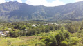
This short walk around Cilaos allows you to appreciate the area’s rich vegetation and varied terrain. It is suitable for everyone and can be combined with a visit to Cilaos.

Details

1884022
Creation:
Last update:
Last review:
  • Walking
    Activity: Walking
  • ↔
    Distance: 2.73 mi
  • ◔
    Average duration: 2h 20 
  • ▲
    Difficulty: Easy

  • ⚐
    Back to start: Yes
  • ↗
    Ascent: + 1,250 ft
  • ↘
    Descent: - 1,237 ft

  • ▲
    Highest point: 4,616 ft
  • ▼
    Lowest point: 3,852 ft

Photos

Description of the walk

Before Cilaos, turn right onto a dirt track to reach the Bras Sec islet. Park along the small road.

(S/E) Walk back down this road for a few metres to reach a junction with a footpath.

(1) Take the path on the left. This path climbs steeply up the side of Bonnet de Prêtre mountain. Continue to the first fork. Take the path on the left. This lovely path winds through magnificent, flower-filled vegetation and is almost flat.

(2) Continue along the Sentier des Calumets for quite some time, skirting around Bonnet de Prêtre. Leave the meadow behind and descend into a more wooded area, following the Ravine des Calumets. Cross a few easy fords on a well-marked path. The path continues to descend through the ravine until you reach the signpost marked ‘Croisée Sentier Gueule Rouge’.

(3) Turn right onto the path that climbs up the side of the Bonnet de Prêtre. The climb is quite steep but very well marked all the way to the Gueule Rouge signpost.

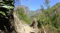
(4) Turn right onto this small country lane, surrounded by lovely vegetation. Continue round a few bends to reach Chemin Saul. Turn right onto the small road Chemin Saul to return to the crossroads you passed on the way out.

(1) Follow the same route as on the way there to return to the starting car park (S/E).

Waypoints

  1. S/E : mi 0 - alt. 4,026 ft - Car park along Chemin Saul at the end of the islet
  2. 1 : mi 0.05 - alt. 4,032 ft - Crossroads at the end of the circular loop
  3. 2 : mi 0.75 - alt. 4,491 ft - Sentier des Calumets
  4. 3 : mi 1.4 - alt. 3,871 ft - Gueule Rouge Trail junction
  5. 4 : mi 2.05 - alt. 4,344 ft - Gueule Rouge Trail
  6. S/E : mi 2.73 - alt. 4,026 ft - Car park along Chemin Saul

Notes

Slippery when wet

Worth a visit

Cilaos

Reviews and comments

4.4 / 5
Based on 3 reviews

Reliability of the description
4.7 / 5
Ease of following the route
4.3 / 5
Route interest
4.3 / 5
pbou
pbou

Overall rating : 4.3 / 5

Date of your route : Sep 08, 2023
Reliability of the description : ★★★★★ Very good
Ease of following the route : ★★★★☆ Good
Route interest : ★★★★☆ Good
Very busy route : Yes

A fairly strenuous walk – not long, but with some steep ascents and descents.
It lacks panoramic views, but the forest is very beautiful and the route is peaceful, set in natural surroundings well removed from civilisation.

Machine-translated

JOUSS
JOUSS

Overall rating : 4.7 / 5

Date of your route : Jul 18, 2022
Reliability of the description : ★★★★★ Very good
Ease of following the route : ★★★★★ Very good
Route interest : ★★★★☆ Good
Very busy route : No

It really was a very pleasant walk. Be wary, however, of the ‘easy’ rating, as some sections require you to be in good physical condition to manage the route without struggling. As we walked it after a spell of rain, the many rocky sections were very slippery despite us having suitable footwear.

Machine-translated

Binouzette
Binouzette
• Edited:

Overall rating : 4.3 / 5

Date of your route : Nov 21, 2021
Reliability of the description : ★★★★☆ Good
Ease of following the route : ★★★★☆ Good
Route interest : ★★★★★ Very good
Very busy route : No

A pleasant circular walk that takes 1 hour 40 minutes to complete. The GPS track is relatively reliable based on the map, though there’s little chance of going astray once you’re on the path.
This walk isn’t very busy and you really feel as though you’re in the middle of nowhere! The return journey along the tarmac road isn’t very pleasant, which is a shame.
Please note that this is a relatively strenuous walk, which I’d classify as ‘moderate’ in difficulty.
Some sections are a bit steep, so take care if you’re doing this with children.

Machine-translated

Other walks in the area

For more walks, use our search engine .

The GPS track and description are the property of this route's author. Please do not copy them without permission.