Departure from Le Bloc, shortly after leaving Cilaos on the road to Bras Sec.
Most of the hike followsGR® trails (red and white markings). On the climb to the summit from the refuge, there are white markings. Information boards are located at various points, particularly at major intersections.
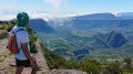
(S) From Le Bloc, take the path heading north towards the Caverne Dufour refuge and Piton des Neiges. There is only one path to the top of the rampart, surrounded by vegetation that becomes less dense as you gain altitude. The climb is generally steep or very steep, with numerous hairpin bends. In places, the path is lined with wooden steps.
(1) The arrival at the intermediate plateau of Petit Matarum is the only moment of respite. The path then turns eastwards and the slope becomes steeper again. A series of short, very steep hairpin bends leads to the edge of the rampart (viewpoint).
(2) Descend slightly and head north to the Caverne Dufour refuge, which is clearly visible from the edge of the rampart (except in thick fog).
(3) Take the Piton des Neiges trail to the north-west. The vegetation becomes sparser and you soon find yourself in a rocky landscape where the trail winds between boulders.
(4) At an altitude of 2,822 metres, the trail turns right (north) to skirt around the foothills. Then head northwest and then west towards the telecommunications antennas. Shortly before reaching these antennas, turn left (southwest) to reach the ridge, which you follow southwards to the summit.
(5) After enjoying the view, descend by the same route to the Refuge de la Caverne Dufour. Then take theGR® on the right to the fork at the edge of the rampart.
(2) Do not take the same route back (GRR1/GRR2) which descends directly to Cilaos via Petit Matarum. Take the GRR2 on the left which heads east towards the Kervéguen hillside. Descend about 100 metres (in elevation) to reach the edge of the rampart known as "Coteau de Kervéguen" at this point. Walk south-east then south along this hillside.
(6) Leave the GRR2, which turns left (southeast) towards the Plaine des Caffres. Begin the descent via a path that winds westwards. The descent is extremely steep; a few low ladders help you negotiate the steepest sections. Be careful, especially if the ground is wet. After numerous switchbacks, you will come out onto a flat area. Head south-west, pass the Sources trail (which comes up on the left) and reach the car park at the edge of the Bras Sec road (E).


 ). Take enough water with you (I took 2 litres, but a third wouldn't have gone amiss) and possibly some snacks for the fastest walkers, or a meal for the others.