


Forest walk between Saint-Roch and Sainte-Anne


Mainly through woodland, as its name suggests, this circular walk takes you on a journey of discovery through the Pouhon valley, starting from the car park and barbecue area near the Saint-Roch secondary school, which is well known throughout the region.
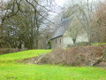
Shortly after crossing the Pouhon near the hamlet of La Levée, the route passes by the Sainte-Anne Chapel and a second barbecue area where you’ll find everything you need for a picnic break or shelter if it rains.
At the five-kilometre mark, after the riding centre, don’t hesitate to enter the grounds of the Misery Brewery and head to the right of the manor house, as the public footpath starts right next to it, between the building and the Paradis stream.
Towards the end of the route, you’ll come across Saint-Roch Chapel between two stretches of countryside.
The return to the starting point follows a section of the old country lane that once linked Comblain-la-Tour to Hotton via Ferrières and Manhay.
Details
–
-
 Activity: Walking
 -
 Distance: 9.42 mi
 -
 Average duration: 5h 10
 -
 Difficulty: Moderate
 -
-
 Back to start: Yes
 -
 Ascent: + 1,004 ft
 -
 Descent: - 997 ft
 -
-
 Highest point: 1,263 ft
 -
 Lowest point: 860 ft
-
 Country:
Belgium
Country:
Belgium
-
 Area: Massif des Ardennes
 -
 City:
Ferrières (Belgique)
City:
Ferrières (Belgique) -
 Start/End: N 50.428337° / E 5.634615°
 -


 Hour-by-hour weather


Photos
Waypoints
- S/E : mi 0 - alt. 1,014 ft - Saint-Roch car park and barbecue area
- 1 : mi 2.37 - alt. 892 ft - Le Pouhon
- 2 : mi 2.81 - alt. 968 ft - St Anne’s Chapel
- 3 : mi 3.19 - alt. 1,010 ft - Misery
- 4 : mi 7.57 - alt. 1,142 ft - Saint-Roch Chapel
- S/E : mi 9.42 - alt. 1,014 ft - Saint-Roch car park and barbecue area
Other walks in the area
Circular route to Xhoris from Harzé
 Visorando Member
 4.73 mi
+656 ft
-640 ft
2h 45
4.73 mi
+656 ft
-640 ft
2h 45
 Easy
Easy
 Departure from Aywaille (Province de Liège)
Circular countryside loop starting from Xhoris
 9.65 mi
+906 ft
-879 ft
5h 15
Moderate
Departure from Hamoir (Province de Liège)
9.65 mi
+906 ft
-879 ft
5h 15
Moderate
Departure from Hamoir (Province de Liège)
From Ernonheid to La Rouge-Minière via Le Paradis
 10.81 mi
+1,201 ft
-1,211 ft
6h 00
Moderate
Departure from Aywaille (Province de Liège)
10.81 mi
+1,201 ft
-1,211 ft
6h 00
Moderate
Departure from Aywaille (Province de Liège)
Ferrières and the tour of the Ruisseau de la Souris
3.70 mi
+387 ft
-387 ft
2h 00
Moderate
Departure from Ferrières (Belgique) (Province de Liège)
Walk in Filot
9.21 mi
+850 ft
-869 ft
5h 00
Moderate
Departure from Hamoir (Province de Liège)
The Grand Trixhe loop
7.05 mi
+367 ft
-364 ft
3h 35
Moderate
Departure from Ferrières (Belgique) (Province de Liège)
Walk at Burnontige
 8.72 mi
+1,063 ft
-1,089 ft
4h 55
Moderate
Departure from Ferrières (Belgique) (Province de Liège)
8.72 mi
+1,063 ft
-1,089 ft
4h 55
Moderate
Departure from Ferrières (Belgique) (Province de Liège)
Burnontige and Les Arsins
 9.29 mi
+1,050 ft
-1,076 ft
5h 10
Moderate
Departure from Ferrières (Belgique) (Province de Liège)
9.29 mi
+1,050 ft
-1,076 ft
5h 10
Moderate
Departure from Ferrières (Belgique) (Province de Liège)
For more walks, use our search engine .
The GPS track and description are the property of this route's author. Please do not copy them without permission.

