


 Country:
 City:
City:


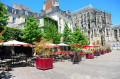
Park in the car park near Saint-Julien Cathedral. The starting point is by the fountain, opposite the steps leading up to the cathedral.
(S/E) Leave the staircase on your left and walk along the bishop’s palace wall that surrounds the cathedral’s chancel, until you reach Rue Robert Triger. Follow this street to Place Saint-Vincent and the very start of Rue Henry Delagénière. There, on your left, go down the steep staircase of the Tertre Maigret.
(1) At the bottom of the steps, turn left into Rue Denfert Rochereau. On the left, you can head up towards the Terrasses du Verger. This area, planted with apple and pear trees, offers a breathtaking view of Le Mans.
Follow Rue Denfert Rochereau, then the Roman ramparts on your left. After passing through the tunnel on Rue Wilbur Wright and walking alongside Rue Saint-Hilaire, turn left. After the Church of Saint-Benoît, take the short Rue Saint-Benoît and then Rue des Poules, one after the other, until you reach the end.
(2) Turn left again and walk along the Fossés Saint-Pierre ramparts, then past the Saint-Pierre-la-Cour Collegiate Church and the Palace of the Counts of Maine and the Plantagenet Kings, which line Avenue Rostov-sur-le-Don. Go through the tunnel to reach the fountain and the car park (S/E).
 Visorando Member
 Tourism professional
 Moderate
