


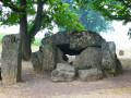
(S/E) Starting from the Wéris Dolmen, the walk begins with a short circular route through the countryside to reach the centre of Wéris, one of the most beautiful villages in Wallonia, whilst avoiding tarmac and motor traffic.
(2) From Wéris, the route climbs through the forest and soon reaches two other megaliths: the Pierre Haina (3) and the Lit du Diable (4).
(4) The magnificent woodland path continues to the Col du Rideux (5) where it gives way to a wide forest track which you follow to the eastern edge of the village of Heyd.
(6) After the farm, take a sharp right onto another lovely little path. Turn left towards the village of Aisne (7) and, three short stretches of road further on, the route reaches the Préalle quarry (8), which it goes round (9) before emerging into the countryside heading towards Tour.
(10) After passing through this hamlet, the route continues through the countryside to join the cycle path situated more or less at the bottom of the valley.
(11) The route follows this cycle path to the right until it reaches the starting point (S/E).
Around Heyd and Morville


A walk offering varied scenery, alternating between countryside and woodland, paths, tracks, village streets, short stretches of country roads and cycle paths, starting from Wéris, one of Wallonia’s most beautiful villages, well known for its megaliths and its museum.
Details
–
-
 Activity: Walking
 -
 Distance: 10.44 mi
 -
 Average duration: 5h 50
 -
 Difficulty: Moderate
 -
-
 Back to start: Yes
 -
 Ascent: + 1,194 ft
 -
 Descent: - 1,198 ft
 -
-
 Highest point: 1,299 ft
 -
 Lowest point: 548 ft
-
 Country:
Belgium
Country:
Belgium
-
 Area: Massif des Ardennes
 -
 City:
Durbuy
City:
Durbuy -
 Start/End: N 50.333686° / E 5.523285°
 -


 Hour-by-hour weather
Photos
Description of the walk
Waypoints
- S/E : mi 0 - alt. 804 ft - Wéris dolmen
- 1 : mi 0.61 - alt. 866 ft - Junction
- 2 : mi 1.11 - alt. 922 ft - Wéris centre
- 3 : mi 2.28 - alt. 1,201 ft - Pierre Haina
- 4 : mi 2.42 - alt. 1,056 ft - Lit du Diable
- 5 : mi 3.61 - alt. 1,220 ft - Col du Rideux
- 6 : mi 4.64 - alt. 925 ft - Junction towards Heyd
- 7 : mi 5.75 - alt. 581 ft - Fork in the road as you approach Aisne
- 8 : mi 6.68 - alt. 548 ft - Préalle Quarry
- 9 : mi 6.98 - alt. 682 ft - Préalle quarry, public track
- 10 : mi 8.5 - alt. 758 ft - Tour (hamlet)
- 11 : mi 9.09 - alt. 801 ft - Cycle path
- S/E : mi 10.44 - alt. 804 ft - Wéris dolmen
Notes
Please note at (9): the route of the paths has been altered (spring 2026) to allow for the expansion of the Préalle quarry. Simply follow the path running alongside the quarry fence.
Paved surface when passing through the centre of Wéris (2), for approximately 500 m before (7), a short stretch on either side of the entrance to the Préalle quarry (8), and on the cycle path between (11) and (S/E)
Worth a visit
Off the route: the Maison de Hary Cot along the small road linking (S/E) directly to the village centre (2).
In the village centre: the Maison des Mégalithes (museum).
Other walks in the area
Discover Wéris and its megaliths
 Visorando Member3.68 mi
+400 ft
-387 ft
2h 05
Moderate
Visorando Member3.68 mi
+400 ft
-387 ft
2h 05
Moderate
 Departure from Durbuy (Province de Luxembourg)
Along the Ourthe between Bohon and Bomal
 11.31 mi
+1,289 ft
-1,266 ft
6h 20
11.31 mi
+1,289 ft
-1,266 ft
6h 20
 Difficult
Departure from Durbuy (Province de Luxembourg)
Difficult
Departure from Durbuy (Province de Luxembourg)
Discover the megaliths and puddingstone around Wéris
 11.82 mi
+1,181 ft
-1,168 ft
6h 30
Difficult
Departure from Durbuy (Province de Luxembourg)
11.82 mi
+1,181 ft
-1,168 ft
6h 30
Difficult
Departure from Durbuy (Province de Luxembourg)
From Bomal-sur-Ourthe Castle to the ruins of Logne Castle
 10.47 mi
+1,526 ft
-1,529 ft
6h 10
Moderate
Departure from Durbuy (Province de Luxembourg)
10.47 mi
+1,526 ft
-1,529 ft
6h 10
Moderate
Departure from Durbuy (Province de Luxembourg)
Dolmens, menhirs and the Aisne Tourist Tramway
 13.38 mi
+1,480 ft
-1,480 ft
7h 25
Difficult
Departure from Erezée (Province de Luxembourg)
13.38 mi
+1,480 ft
-1,480 ft
7h 25
Difficult
Departure from Erezée (Province de Luxembourg)
Circular in the Petit-Han Woods
4.23 mi
+131 ft
-118 ft
2h 05
 Easy
Departure from Durbuy (Province de Luxembourg)
Easy
Departure from Durbuy (Province de Luxembourg)
Walk in Famenne-Ardenne from Petit-Han
 10.95 mi
+397 ft
-410 ft
5h 25
Moderate
Departure from Durbuy (Province de Luxembourg)
10.95 mi
+397 ft
-410 ft
5h 25
Moderate
Departure from Durbuy (Province de Luxembourg)
From the Petit-Han Woods to the N833
2.28 mi
+72 ft
-52 ft
1h 05
Easy
Departure from Durbuy (Province de Luxembourg)
For more walks, use our search engine .
The GPS track and description are the property of this route's author. Please do not copy them without permission.

