East peak of Mont Lantin and Escourtines balcony

Hike in the least frequented part of the Calanques National Park: the Saint Cyr massif. It is located in the easternmost part on the slopes of Mont Lantin (571 m).

You are in the Calanques National Park, which is subject to specific regulations. Failure to comply with these regulations may result in a fine of up to €1,500.

Details

75012
Creation:
Last update:
Last review:
  • Walking
    Activity: Walking
  • ↔
    Distance: 10.62 km
  • ◔
    Average duration: 5h 20 
  • ▲
    Difficulty: Moderate

  • ⚐
    Back to start: Yes
  • ↗
    Ascent: + 804 m
  • ↘
    Descent: - 800 m

  • ▲
    Highest point: 504 m
  • ▼
    Lowest point: 91 m

Photos

Description of the walk

The hike starts from the car park at the Candolle Cemetery.

(S/E) Take the dead-end road that runs along the cemetery fence on the left. Opposite the entrance and at the end, take the concrete path on the left marked "Accès à la Forêt Communale" (Access to the Communal Forest). At the end of this short path, continue along the fence until you see a signpost indicating the blue route. Follow this blue route to the right along the track. The track descends steeply and then climbs again immediately. You will come to a fork in the tracks

(1). For a change, leave the blue trail (you will take it on the way back) and take the track on the right which climbs and then becomes steeper (concrete section). The track climbs less steeply.

(2) After 50 m, turn onto an unmarked but clearly visible path on the right. You will reach a cistern (at an altitude of about 235 m), which you go around on the right. Two routes start from here but both lead to the same place, where they join the yellow route from La Candolle. You will quickly reach the pass between Candolle-Escourtines (260 m) where the trail forks.

(3) Leave the path that climbs south on your left and turn right (west) to descend into the Escourtines valley. After a steep rocky section (use your hands), descend the path and after a slightly unstable scree slope, you will reach a fork.

(4) Take the left (south). The route is no longer marked, but the trail is still clearly visible. Climb up a shady valley (southwest) which widens and ends with a steep scree slope. The path is less visible but cairns guide you to a track. Continue right on this track and you will reach a promontory overlooking the Escourtines valley. Descend as best you can on the left towards the south (it's always passable). You will return to the start of the Quarres valley.

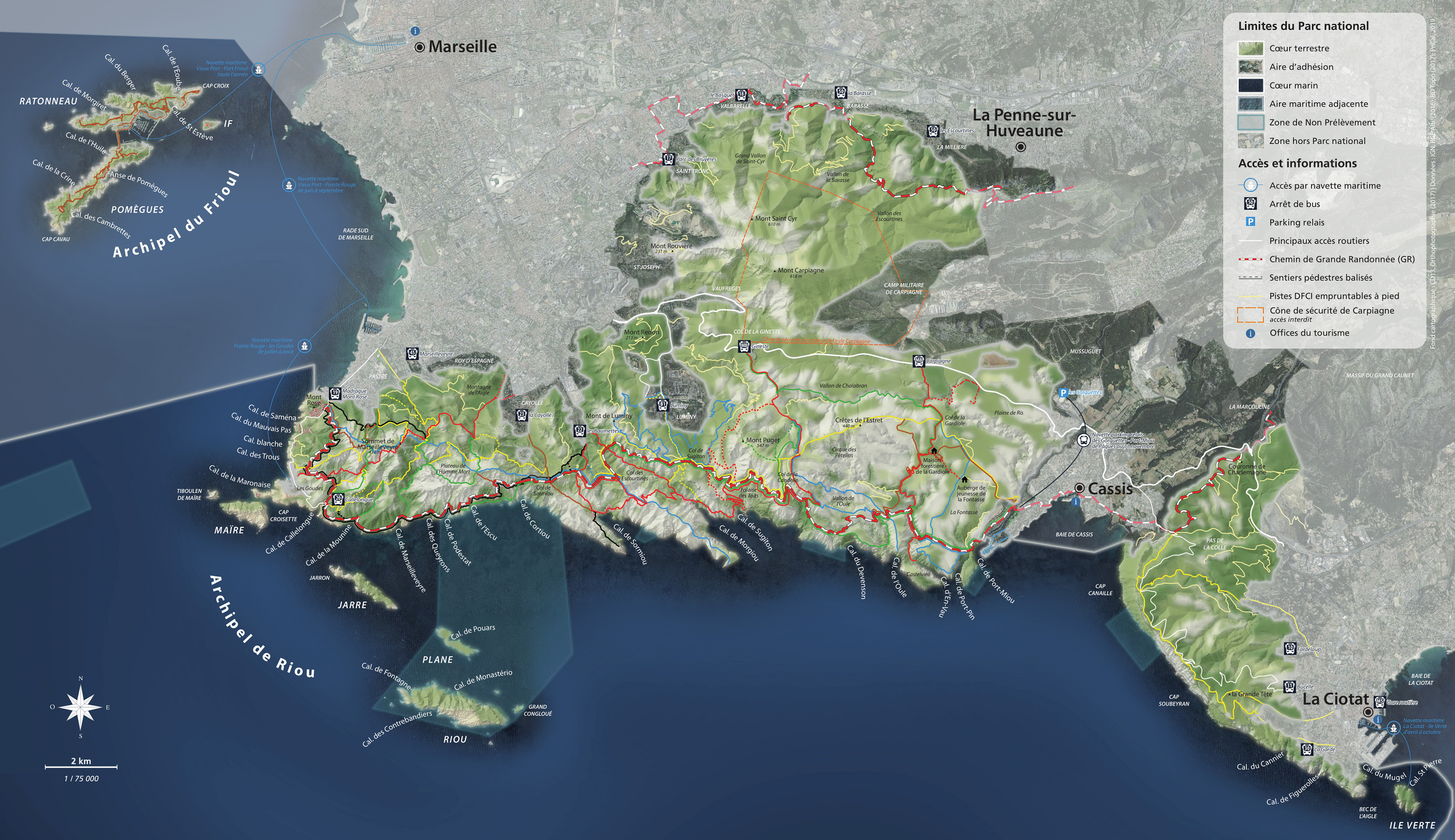
(5) Resume the climb south on a stony path with old yellow markings. At the end (boundary marker), you will reach the eastern pre-summit of Mont Lantin (504 m), the highest point of the hike, which overlooks the Carpiagne military camp. From here, there is a superb view of Cassis, Cap Canaille and the Var coast.
The yellow trail continues towards Mont Lantin, but access to this part is restricted due to the military camp.

(6) Descend via the same path, keeping to the left. After a few minutes, you will come to a cairn indicating the start of the path that leads through the Escourtines valley.

(5) This unmarked trail heads south-east, along a ledge, before descending north-west. The descent is mainly in the valley and remains in the shade in the morning. The trail heads north and passes two rocky obstacles without much difficulty. The trail heads northeast and the valley narrows before coming to a fork where you will find a yellow marker.

(7) Take the left, heading due west, over easy rocks. The yellow trail climbs quite steeply then heads north and becomes less steep. You will reach the Limite pass, the crossing point between the Escourtines and Luinant valleys. Leave the yellow markings, which descend into the Luinant valley, and take the blue trail on the right, which climbs up the rocks and reaches the Escourtines balcony (marker 432m - not named on the maps). The descent is on the eastern slope, which is steep at first and then reaches a fork. To the left (north), the trail descends towards La Millière. Continue east, following a ridge overlooking the Escourtines valley. The trail heads north, descends in switchbacks under the pine trees and ends with a passage through the rocks (easy). You will reach the road (car park). Head south (yellow trail) up the Escourtines valley. In this section, the valley is very steep and densely wooded. You will reach another fork in the yellow trail. Take the left path up steep slopes and over rocks (sometimes slippery) until you reach the fork you passed on the way up.

(4) The climb to the pass follows the same route, then you reach the Citerne.

(8) For a change, you can take the same route up, then descend directly via a path that crosses the track and reaches another cistern:

:9::. Then follow the blue route back to the starting point.

Waypoints

  1. S/E : km 0 - alt. 91 m - Candolle Cemetery car park
  2. 1 : km 0.31 - alt. 107 m - Fork in the road
  3. 2 : km 0.81 - alt. 180 m - Fork in the path: unmarked trail
  4. 3 : km 1.26 - alt. 258 m - :Western fork
  5. 4 : km 1.53 - alt. 207 m - South fork
  6. 5 : km 3.51 - alt. 471 m - South-facing climb
  7. 6 : km 3.7 - alt. 503 m - East peak of Mont Lantin
  8. 7 : km 5.47 - alt. 227 m - Western fork
  9. 8 : km 9.39 - alt. 228 m - Fork in the road
  10. 9 : km 9.65 - alt. 172 m - Cistern
  11. S/E : km 10.62 - alt. 91 m - Candolle Cemetery car park

Notes

Please note: you are in Provence and due to the risk of fire, access to the forest is restricted from 1 June to 30 September. Every evening before 6pm, the official website provides information on the conditions for the following day.
Access may be authorised, restricted from 6 a.m. to 11 a.m. or completely prohibited if the wind is strong.
Bring water with you, as there are no water sources in this forest. If necessary, the cemetery (at the start) has a drinking water supply.

Worth a visit

The Calanques massif stretches from the coast to the small coastal river Huveaune, and the Saint-Cyr massif is cut off from the rest of the park by the Gineste road, which connects Marseille to Cassis, and includes the three highest peaks: Carpiagne (640 m), Saint-Cyr (610 m) and Lantin (570 m).
From the two highest points of the route, the circular view stretches from the calanques to the harbour of Marseille and the massifs of Provence (Étoile, Sainte-Baume).

Reviews and comments

4.7 / 5
Based on 20 reviews

Reliability of the description
4.7 / 5
Ease of following the route
4.6 / 5
Route interest
4.9 / 5
Christophe Tardieux
Christophe Tardieux

Overall rating : 4.3 / 5

Date of your route : Apr 22, 2024
Reliability of the description : ★★★★☆ Good
Ease of following the route : ★★★★☆ Good
Route interest : ★★★★★ Very good
Very busy route : No

A beautiful and varied hike with stunning views
Thanks for sharing!

Machine-translated

marcv1313
marcv1313

According to the map provided by the Calanques National Park, it would appear that this hike crosses the boundaries of the "Carpiagne firing range safety zone". However, I have not verified this...
http://www.calanques-parcnational.fr/sit...

Machine-translated

Pseudo en cours de chargement

Overall rating : 4.7 / 5

Date of your route : Dec 03, 2022
Reliability of the description : ★★★★★ Very good
Ease of following the route : ★★★★☆ Good
Route interest : ★★★★★ Very good
Very busy route : No

Very beautiful view at point 5.
Very pleasant route throughout the hike.

Machine-translated

Le Gabian
Le Gabian
• Edited:

Overall rating : 5 / 5

Date of your route : Mar 09, 2022
Reliability of the description : Not used / Not applicable
Ease of following the route : ★★★★★ Very good
Route interest : ★★★★★ Very good
Very busy route : No

Very good route, would be even better if you added the recently cleared northern ridge of La Candolle (GR 2013). Hi

Machine-translated

mickii13
mickii13

Overall rating : 4.3 / 5

Date of your route : May 04, 2021
Reliability of the description : ★★★★★ Very good
Ease of following the route : ★★★☆☆ Average
Route interest : ★★★★★ Very good
Very busy route : No

nice ride, keep an eye on your GPS, 360-degree view of the route, lacks precision when paths cross, especially at level 4

Machine-translated

saniere
saniere

Overall rating : 5 / 5

Date of your route : Apr 10, 2021
Reliability of the description : ★★★★★ Very good
Ease of following the route : ★★★★★ Very good
Route interest : ★★★★★ Very good
Very busy route : No

A beautiful walk to do in spring, with irises in abundance and a stunning 360° view as a reward. On the way back, you need to pay attention to take the right turn at the right time to start the descent, keeping an eye on the GPS track

Machine-translated

saniere
saniere

Overall rating : 5 / 5

Date of your route : Apr 10, 2021
Reliability of the description : ★★★★★ Very good
Ease of following the route : ★★★★★ Very good
Route interest : ★★★★★ Very good
Very busy route : No

A lovely walk to do in spring, with irises galore and a beautiful 360° view as a reward

Machine-translated

Philippe Issa
Philippe Issa

Overall rating : 4.3 / 5

Date of your route : Jun 25, 2020
Reliability of the description : ★★★★☆ Good
Ease of following the route : ★★★★☆ Good
Route interest : ★★★★★ Very good
Very busy route : No

A beautiful hike starting from the Huveaune Valley. I spotted a deer (a roe deer) looking very comfortable near Camp de Carpiagne, where gunshots were regularly heard. The route consists of ascents and descents. Best regards

Machine-translated

devouassoud
devouassoud

Overall rating : 4.7 / 5

Date of your route : Dec 23, 2019
Reliability of the description : ★★★★★ Very good
Ease of following the route : ★★★★★ Very good
Route interest : ★★★★☆ Good

Nice hike, but how are the boundaries of the restricted military zone marked? Is it the line with the crosses and black lines? I did this hike and was worried that I might have crossed the boundary. Thank you

Machine-translated

henri57
henri57 ★

Hello,

Thank you for your feedback.

The GPS coordinates of the points do not match those of a CARMIN GPS.

I'm surprised, as it works perfectly at (it may be a settings issue )

Could you tell me the type of Garmin GPS you have (Etrex 10, 20, GPSmap 62, 64, 66, etc.)?

Here is the method I use with my Garmin Etrex 30 and my GPSMAP 66S

The ETREX 30, 30x or 32x manual, valid for all Garmin devices

If you need help fine-tuning your settings, you can use the forum.

Forum

See you soon

Machine-translated

FAYEL
FAYEL

Overall rating : 4.3 / 5

Date of your route : Dec 01, 2019
Reliability of the description : ★★★★☆ Good
Ease of following the route : ★★★★☆ Good
Route interest : ★★★★★ Very good

The hike offers a view of the splendid Var coastline.
From the summit of Mont Lantin, you can continue to the top of the mountain for an even better view of Marseille. The path down to the Escourtines valley is steep and not always easy to follow.
The GPS coordinates do not correspond to a CARMIN GPS.
Best regards

Machine-translated

Rando5913
Rando5913

Overall rating : 5 / 5

Date of your route : Dec 16, 2019
Reliability of the description : Not used / Not applicable
Ease of following the route : Not used / Not applicable
Route interest : ★★★★★ Very good

Very parish specific to Brittany view for a lunch stop.

Machine-translated

clamx
clamx

Overall rating : 5 / 5

Date of your route : Sep 19, 2019
Reliability of the description : ★★★★★ Very good
Ease of following the route : ★★★★★ Very good
Route interest : ★★★★★ Very good

A beautiful hike, quite challenging due to its rather dry climbs and scree slopes on the descent and ascent. One minor drawback is that the paths are narrow and overgrown due to lack of use or maintenance.
Best regards
Cl

Machine-translated

ams01031954
ams01031954

hello, I haven't done the hike yet. I'll come back to the site once I've done it. Best regards

Machine-translated

Ludicus
Ludicus

Overall rating : 4.7 / 5

Date of your route : Mar 17, 2019
Reliability of the description : ★★★★★ Very good
Ease of following the route : ★★★★☆ Good
Route interest : ★★★★★ Very good

Quite a physically demanding route. Stunning views. We almost went up Mount Lantin but changed our minds when we thought about the return journey. Impossible to get lost, even without a map or compass, with the description you provide. Well done, Visorando!

Machine-translated

Other walks in the area

For more walks, use our search engine .

The GPS track and description are the property of this route's author. Please do not copy them without permission.